

Landkaart Wegenkaart 5 Midlands Oost & East Anglia - OSI
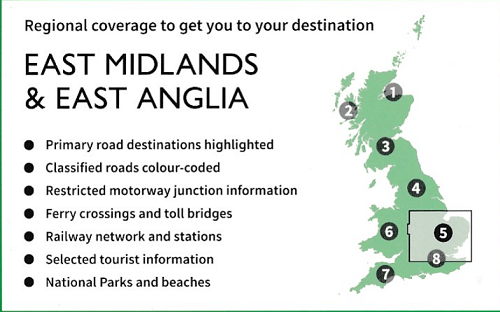
East Midlands - Norfolk and the Thames Estuary

Korte omschrijving
Wegenkaart Midlands Oost & East Anglia - OSI Productomschrijving: Plan your journey with this series of road maps from OS. Showing all major road, rail and ferry links as well as settlement...

Specificaties
- Uitgever: Ordnance Survey
- ISBN-13: 9780319263778
- HOOFDCATEGORIEËN: Wegenkaart - Landkaart
- Activiteiten: Street/Road maps & city plans
- Regio: East Anglia, England, Midlands, England
- Land: England
- Schaal: 1:250000
- Taal: Engels
- Reeks/Serie: OSI Regional UK Roadmaps 1:250.000
Volledige omschrijving
Wegenkaart Midlands Oost & East Anglia - OSI
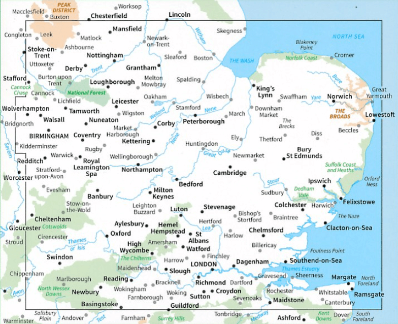
Productomschrijving: Plan your journey with this series of road maps from OS. Showing all major road, rail and ferry links as well as settlements and selected features in 1: 250 000 scale, this is the ideal map for planning trips and holidays by car or cycle.
OS Road 5 covers: the East Midlands, including the Norfolk and the Thames Estuary.
Overzichtskaarten
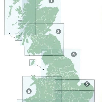
OSI Roadmaps UK 1 > 8 - 1:250.000
OSI Roadmaps UK 1 > 8 - 1:250.000

Producten op de overzichtskaart
Klik op een product om naar de detailpagina te gaan.
- Landkaart Wegenkaart 1 Schotland Noord - OSI
- Landkaart Wegenkaart 2 Schotland West & Western Isles - OSI
- Landkaart Wegenkaart 3 Schotland Zuid & Northumberland - OSI
- Landkaart Wegenkaart 4 Engeland Noord - OSI
- Landkaart Wegenkaart 5 Midlands Oost & East Anglia - OSI
- Landkaart Wegenkaart 6 Wales & Midlands West - OSI
- Landkaart Wegenkaart 7 Zuidwest Engeland & Zuid Wales - OSI
- Landkaart Wegenkaart 8 Zuidoost Engeland - OSI
Artikelen uit dezelfde regio

Wandelgids Dark Peak Walks in the Peak District - Cicerone • 9781852845193
Wandelgids - Dark Peak Walks in the Peak District - Cicerone Productomschrijving: Het Nationaal park Peak District, is een zeer heuvelrijk nationaal park in het noorden van Engeland. Meestal wordt het onderverdeeld in het noordelijke Dark Peak, waar vooral veel heidegebieden zijn en het zuidelijke White Peak, waar de meeste mensen wonen. Product description: Located in the Peak Distric…

Reisgids Go Slow Cambridgeshire & The Fens - Bradt • 9781784777456
Go Slow Cambridgeshire & The Fens - Bradt gudes Productomschrijving: Dit nieuwe boek voegt Cambridgeshire and the Fens toe aan Bradt's bekroonde Slow Travel serie - de grootste serie Britse regionale reisgidsen, nu al meer dan 20 titels sterk. Geen enkele andere titel biedt zo veel en zo diepgaande informatie over deze gevarieerde, mooie en verrassend onontdekte regio. Cambridge zelf …

Wandelkaart 21 North Norfolk Coast - AA • 9780749573270
Wandelkaart 21 - North Norfolk Coast - AA Productomschrijving: AA, in samenwerking met Ordinance Survey, heeft een reeks kaarten ontwikkeld die zich op populaire toeristische bestemmingen van de UK richten, zodat meerdere OS-kaarten niet vereist zijn. Deze kaart richt zich op de Norfolk Broads uit Lowestoft in het oosten aan Coltishall in het westen en uit Bungay in het zuiden tot Sea Pall…

Wandelgids The Ridgeway National Trail - Trailblazer Publ. • 9781912716524
The Ridgeway National Trail - Trailblazer Publications Productomschrijving: The Ridgeway: Avebury to Ivinghoe Beacon - 53 maps - 46 colour photos, - 4pp colour flower & butterfly guide An 87-mile (139km) National Trail, the Ridgeway runs from Overton Hill near Avebury in Wiltshire to Ivinghoe Beacon in Buckinghamshire. Part of this route follows Britain’s oldest road, dating b…

Wandelgids White Peak walks Southern Dales - Cicerone • 9781852845186
Wandelgids - White Peak walks Southern Dales - Cicerone Productomschrijving: Deze gids gaat over wandelen in de zuidelijke dales van de witte piekoppervlakte van het Peak District, tussen Ashbourne, Matlock, Buxton en Leek. 30 gemakkelijke circulaire routes doorsteken de hoge plateau en volgen de Dove, Manifold en Hamps rivieren door de dales in het UK's eerste Nationaal Park. Eén van twee…