

Landkaart Wegenkaart 1 Schotland Noord - OSI
North-East Scotland, Orkney Islands & Shetland ISlands

Korte omschrijving
Wegenkaart Schotland Noord - OSI Productomschrijving: Plan your journey with this series of road maps from OS. Showing all major roads, rail and ferry links as well as settlements and selec...

Specificaties
- Uitgever: Ordnance Survey
- ISBN-13: 9780319263730
- HOOFDCATEGORIEËN: Wegenkaart - Landkaart
- Activiteiten: Street/Road maps & city plans
- Regio: Northern Schotland, Highlands & Islands
- Land: Schotland
- Schaal: 1:250000
- Taal: Engels
- Reeks/Serie: OSI Regional UK Roadmaps 1:250.000
- De beroemdste Eilandengroepen: Orkney Islands (Schotland), Schetland Islands (Schotland)
Volledige omschrijving
Wegenkaart Schotland Noord - OSI
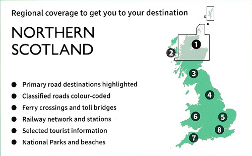
Productomschrijving: Plan your journey with this series of road maps from OS. Showing all major roads, rail and ferry links as well as settlements and selected features in 1: 250 000 scale, this is the ideal map for planning trips and holidays by car or cycle.
OS Road 1 covers North-East Scotland, Orkney and Shetland (shown in 1: 400 000 scale).

Overzichtskaarten
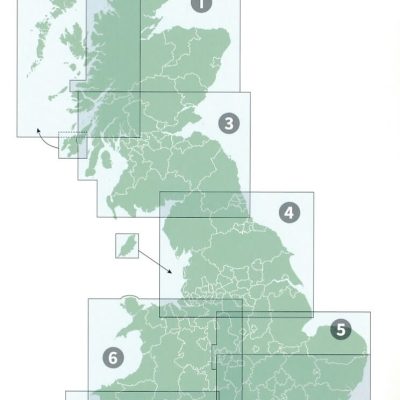
OSI Roadmaps UK 1 > 8 - 1:250.000
OSI Roadmaps UK 1 > 8 - 1:250.000

Producten op de overzichtskaart
Klik op een product om naar de detailpagina te gaan.
- Landkaart Wegenkaart 1 Schotland Noord - OSI
- Landkaart Wegenkaart 2 Schotland West & Western Isles - OSI
- Landkaart Wegenkaart 3 Schotland Zuid & Northumberland - OSI
- Landkaart Wegenkaart 4 Engeland Noord - OSI
- Landkaart Wegenkaart 5 Midlands Oost & East Anglia - OSI
- Landkaart Wegenkaart 6 Wales & Midlands West - OSI
- Landkaart Wegenkaart 7 Zuidwest Engeland & Zuid Wales - OSI
- Landkaart Wegenkaart 8 Zuidoost Engeland - OSI
Artikelen uit dezelfde regio

Wandelkaart Ben Ledi and hills north of Callander - Harvey maps • 9781851374663
Wandelkaart Ben Ledi and hills north of Callander - Harvey maps Productomschrijving: Aberfoyle en Callander, naar het noorden richting Balquhidder te Merin. Deze kaart voor hillwalkers omvat Ben Vorlich en Stuc a'Chroin (2 Munros), en Ben Ledi, één van de 3 Corbetts. Loch Venachar, Strathyre en de Trossachs. Nieuwe generatie HARVEY Superwalker, XT25 waterproof, werden ontworpen om de m…

Wandelkaart XT25 Ben Alder Highlands Schotland - Harvey Maps • 9781851375493
Wandelkaart XT25 - Ben Alder Highlands - Harvey Maps Productomschrijving: Dalwhinnie, net naast de Ben Alder, is een dorp op de noordoostelijke oever van Loch Ericht ten noorden van Drumochter in de Schotse lieutenancy Inverness in het raadsgebied Highland. In de Dalwhinnie Distillery onderdeel van Diageo produceert men Dalwhinnie Single Malt, een Highland single malt whisky. Nieuwe ge…

Wandelkaart XT40 John o'Groats Trail - Harvey Maps • 9781851376650
Wandelkaart John o'Groats Trail - Harvey Maps Productomschrijving: Gehele route op één kaart - De John o' Groats Trail is een wandelroute van 237 km (147 miles) langs de Schotse kust van Inverness tot John o' Groats en gaat over stranden, kliffen, langs rustige wegen en wandelpaden. De wandeling omvat een aantal van de meest dramatische landschappen in Groot-Brittannië, met natuurlijk…
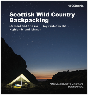
Wandelgids Scottish Highlands & Islands Wild country backpacking • 9781852849047
Scottish Highlands & Islands Wild country backpacking Productomschrijving: 30 wilde en uitdagende rugzak-/trekkingroutes in Schotland. De routes zijn bedoeld voor ervaren en zelfredzame backpackers en zijn tussen 2 en 4 dagen lang en doorkruisen de meest afgelegen, wilde en spectaculaire landschappen die de Highlands te bieden hebben. Het boek behandelt ook uitrusting, toegang, het weer, v…

Wandelkaart XT40 Glen Affric Schotland - Harvey maps • 9781851375950
Wandelkaart XT40 - Glen Affric Schotland - Harvey maps Productomschrijving: Dit is een natuurreservaat ten Zuid-Oosten van het dorpje Cannich in de Schotse Highlands, een dikke 24 km ten westen van Loch Ness. De river de Afric loopt langs dit reservaat, en loopt langs Loch Affric en Loch Beinn a Mheadhoin. Een kleine grint-weg brengt tot bij het einde van de Loch Beinn a Mheadhoin, maar vo…