

Wandelgids Day Walks in Fort William & Glen Coe - Vertebrate publ
20 routes in the Scottish Highlands

Korte omschrijving
Wandelgidsen Northern Schotland, Highlands & Islands en Highlands, Schotland van Vertebrate Publishing. Ideaal voor tochten in Schotland.
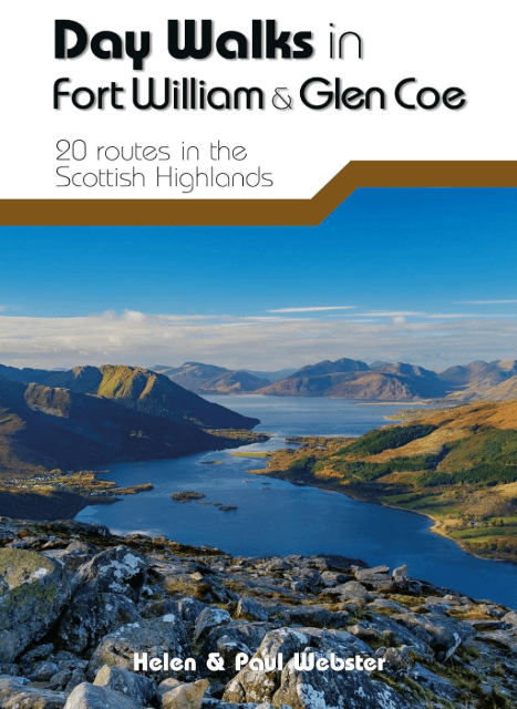
Day Walks in Fort William & Glen Coe Scotland Productomschrijving: 20 routes in the Scottish Highlands Day Walks in Fort William & Glen Coe features 20 routes between 4.4 and 14.4 miles...

Specificaties
- Uitgever: Vertebrate Publishing
- ISBN-13: 9781912560646
- HOOFDCATEGORIEËN: Wandelgids
- Activiteiten: Wandelen, Hiking & Trekking
- Auteur: Helen Webster, Paul Webster
- Regio: Highlands, Schotland, Northern Schotland, Highlands & Islands
- Land: Schotland
- Lange afstand wandelroutes: West Highland Way, Schotland (152 km)
- Taal: Engels
- Reeks/Serie: Day walks in, vertebrate Publishing
- Iconische Bergketens van Europa: De Schotse Highlands
- Iconische Wandelroutes: West Highland Way, Schotland
- De Schotse Munro's: De Schotse Munro's
Volledige omschrijving
Day Walks in Fort William & Glen Coe Scotland
Productomschrijving: 20 routes in the Scottish Highlands
Day Walks in Fort William & Glen Coe features 20 routes between 4.4 and 14.4 miles (7km and 23.2km) in length, spread across the Scottish Highlands. Researched and written by experienced and knowledgeable authors Helen and Paul Webster, founders of the Walkhighlands website, the walks range from gentle rambles to more challenging day walks, all through grand and impressive landscapes. Split into four sections – Glen Coe & Glen Etive, Kinlochleven & the Mamores, Fort William & the Great Glen, and The Road to the Isles – this guidebook explores the best that the Highlands has to offer. Together with stunning photography, each route features Ordnance Survey 1:25,000 maps, easy-to-follow directions, details of distance and navigation information, and refreshment stops and local information.

Artikelen uit dezelfde regio
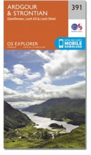
Wandelkaart 391 Ardgour & Strontian- Schotland - OSI • 9780319472545
Wandelkaart Ardgour & Strontian - Highland's Schotland Omvat ook: Glenfinnan, Loch Eil & Loch Shiel. Productbeschrijving: Kaart nummer 391 in de OS Explorer kaart reeks is ideaal voor ontdekken van het gebied in de buurt van de Ben Nevis & Loch Linnhe. Net ten westen van Ben Nevis en Glen Coe vallen er prachtige landschappen en uitdagende wandelingen te ontdekken terwijl u een bezoek b…
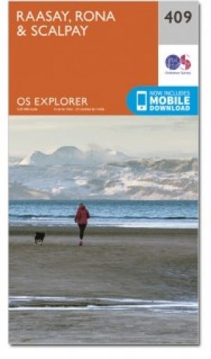
Wandelkaart 409 Raasay Rona & Scalpay Schotland - OSI • 9780319472644
Wandelkaart Raasay- Rona & Scalpay - Highland's Schotland Productbeschrijving: Kaart nummer 409 in de OS Explorer kaart reeks is ideaal voor het verkennen van de Isle of Skye, Raasay, Rona en Scalpay. Hoogtepunten van het gebied zijn onder andere: Dun Caan, Brochel castle, clear Hebridean waters, & The Storr. De OS Explorer kaart voor Raasay, Rona & Scalpay is beschikbaar in zowel de stand…

Wandelgids West Highland Way Scottish Highlands - Floor Denil • 9789083485058
The West Highland Way Scottish Highlands - Floor Denil Productomschrijving: “Ah, the West Highland Way – the 154 Km long trail where my annual hiking adventures began. Surpri ingly (or perhaps not), many fellow hikers share a similar sentiment. It’s a popular choice for those embarking on their first long-distance hiking experience.” Embark on the renowned West Highland Way with this …
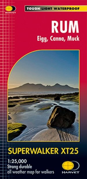
Wandelkaart XT25 Rum- Eigg- Canna & Muck - Harvey maps • 9781851375424
Wandelkaart Rum - Eigg - Canna & Muck - Harvey maps Productomschrijving: Deze gedetailleerde wandel- en fietskaart bedekt de Scottish Islands van Rum, Eigg, Canna en Muck. De kaart toont 2 Corbetts en 1 Graham.. Het formaat geeft meer toewijzingen op het blad zonder dat de kaart zwaarder en volumineuzer wordt. Nieuwe generatie HARVEY Superwalker, XT25 waterproof, werden ontworpen om d…

Wandelkaart 414 Glen Shiel & Kintail Forest Schotland OSI • 9780319472699
Wandelkaart Glen Shiel & Kintail Forest - Highland's Schotland Omvat ook: Shiel Bridge, Morvich, Killilan & Kinloch Hourn. Productbeschrijving: Als u van plan bent om zoveel Munros mogelijk af te lopen, gaat u deze OS Explorer kaart 414 nodig hebben. Met 32 Munros op één dubbelzijdige kaart heeft dit gebied ook drie nationale natuurgebieden, Loch Cluanie en Loch Quoich. De OS Explorer …