

Wandelkaart 181 Minehead & Brendon Hills- England - OSI
Walk the South West Coast Path to Minehead & Exmoor NP


Korte omschrijving
Wandelkaarten Somerset South West England van Ordnance Survey. Ideaal voor tochten in England.
Wandelkaart Minehead & Brendon Hills - Exmoor NP Somerset Productbeschrijving: De OS Landranger kaarten reeks heeft betrekking op Groot-Brittannië met 204 gedetailleerde kaarten, perfect voo...

Specificaties
- Uitgever: Ordnance Survey
- ISBN-13: 9780319475041
- HOOFDCATEGORIEËN: Wandelkaart
- Activiteiten: Wandelen, Hiking & Trekking
- Regio: Somerset South West England
- Land: England
- Waterafstotende kaart: Ordnance Survey ACTIVE Landranger Weatherproof Maps
- Nationale parken: Exmoor NP, Devon England
- TOPO's & Stafkaarten: Topografisch wandelen
- Schaal: 1:50000
- Taal: Engels
- Reeks/Serie: Landranger ACTIVE series OSI
Volledige omschrijving
Wandelkaart Minehead & Brendon Hills - Exmoor NP Somerset
Productbeschrijving: De OS Landranger kaarten reeks heeft betrekking op Groot-Brittannië met 204 gedetailleerde kaarten, perfect voor dagtochten en korte pauzes. Elke kaart bevat alle informatie die u nodig heeft om dit lokaal gebied te leren kennen en omvat plaatsen van belang, toeristische informatie, picknickplaatsen en campings, plus doorgangsrechten informatie voor Engeland en Wales.
Productdiscription: The OS Landranger Map series covers Great Britain with 204 detailed maps, perfect for day trips and short breaks. Each map provides all the information you need to get to know your local area and includes places of interest, tourist information, picnic areas and camp sites, plus Rights of Way information for England and Wales.
Locatie op kaart
Overzichtskaarten

OSI Landranger & Landranger Active - Land's End - Devon - Cornwall
OSI Landranger & Landranger Active - Land's End - Devon - Cornwall
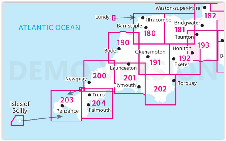
Producten op de overzichtskaart
Klik op een product om naar de detailpagina te gaan.
- Wandelkaart 180 Barnstable & Ilfracombe- Devon England - OSI
- Wandelkaart 180 Barnstaple & Ilfracombe- Devon England - OSI
- Wandelkaart 181 Minehead & Brendon Hills- England - OSI
- Wandelkaart 181 Minehead & Brendon Hills- England - OSI
- Wandelkaart 182 Weston-super-Mare & Bridgwater- England - OSI
- Wandelkaart 182 Weston-super-Mare- Somerset England - OSI
- Wandelkaart 190 Bude & Clovelly- Cornwall England - OSI
- Wandelkaart 190 Bude- Clovelly & Boscastle - OSI
- Wandelkaart 191 Okehampton & North Dartmoor NP - OSI
- Wandelkaart 191 Okehampton & North Dartmoor NP - OSI
- Wandelkaart 192 Exeter & Sidmouth- Devon - OSI
- Wandelkaart 192 Exeter- Sidmouth & Exmouth - OSI
- Wandelkaart 193 Taunton & Lyme Regis- England - OSI
- Wandelkaart 193 Taunton & Lyme Regis- Somerset - OSI
- Wandelkaart 200 Newquay- Bodmin & Camelford - OSI
- Wandelkaart 200 Newquay & Bodmin Cornwall - OSI
- Wandelkaart 201 Plymouth & Launceston England - OSI
- Wandelkaart 201 Plymouth & Launceston England - OSI
- Wandelkaart 202 Torbay - South Dartmoor NP - OSI
- Wandelkaart 202 Torbay & South Dartmoor - OSI
- Wandelkaart 204 Truro- Falmouth & Roseland - OSI
- Wandelkaart 204 Truro & Falmouth- Cornwall England - OSI
- Wandelkaart 203 Land's End & Isles of Scilly - OSI
- Wandelkaart 203 Land's End & Isles of Scilly - OSI
Artikelen uit dezelfde regio

Wandelkaart 141 Shepton Mallet & Mendip Hills East - OSI • 9780319470138
Wandelkaart Shepton Mallet & Mendip Hills East - England Productbeschrijving: Kaart nummer 141 in de OS Explorer kaarten reeks heeft betrekking op de westelijke Mendip Hills, Cheddar, Wells Street en Glastonbury. Hoogtepunten van het gebied zijn onder andere: Cheddar Gorge, Wookey Hole, Glastonbury Tor, Blagdon, de Chew Valley Lakes en de rivieren bijl, Brue en Cary. De OS Explorer kaart …

Wandelgids & Fietsgids - The Cotswold AONB - Cicerone • 9781852847067
Wandelgids & Fietsgids - The Cotswold AONB - Cicerone Productomschrijving: De Cotswolds is de thuisbasis van mooie honing-hued stenen dorpen in een glooiende landschap. De dramatische 100-mijl lange kalkstenen helling biedt een adembenemend uitzicht, terwijl het netwerk van rustige wegen, fietsvriendelijke kanaalwegen, sporen en ruiterpaden perfect is voor verkenning op een fiets. De Cotwo…

Wandelgids Cotswolds - Heart of the Cotswolds - Rucksack Readers • 9781913817268
Wandelgids Cotswolds - Heart of the Cotswolds - Rucksack Productomschrijving: The Cotswolds AONB is quintessentially English, with its rich cultural history, medieval ‘wool’ churches and charming domestic architecture of stone, slate and thatch. The book offers three options for walking in the heart of this wonderful area: a 94-mile (151-km) grand tour starting from Cheltenham, and two sh…

Wandelgids - Cotswold Classic Walks - Goldeneye • 9781859652916
Cotswold Classic Walks - Goldeneye Productomschrijving: Met 25 rondwandelingen helpt dit boek u een uitvalsbasis te vinden om de auto te ontvluchten en te genieten van een weekend vol frisse lucht en beweging.... Sommige wandelingen bieden verschillende routemogelijkheden en links naar andere wandelingen. Hoe beslist u welke wandeling u gaat doen? - Waar zijn de mooiste uitzichten? - W…

Wandelgids 009 Pathfinder guides Exmoor NP & the Quantocks - OS • 9780319090114
Wandelgids Exmoor National Park & the Quantocks - OS Productomschrijving: Exmoor National Park comprises 265 square miles, of which about two-thirds lie in west Somerset and the remaining third in north Devon. This walking guidebook contains 28 circular, graded walks in Exmoor, all tried and tested by seasoned walkers. The routes range from extended strolls to longer hikes, so there is som…