

Wandelkaart 180 Barnstaple & Ilfracombe- Devon England - OSI
Omvat de Northern Coast of Devon- on the Bristol Channel


Korte omschrijving
Wandelkaarten Devon, England van Ordnance Survey. Ideaal voor tochten in England.
Wandelkaart Barnstaple & Ilfracombe- Lynton - North Devon Productbeschrijving: Kaart nummer 180 is een all purpose kaart vol gepakt met informatie om u het gebied te helpen leren kennen. De ...

Specificaties
- Uitgever: Ordnance Survey
- ISBN-13: 9780319475034
- HOOFDCATEGORIEËN: Wandelkaart
- Activiteiten: Wandelen, Hiking & Trekking
- Regio: Devon, England
- Land: England
- Waterafstotende kaart: Ordnance Survey ACTIVE Landranger Weatherproof Maps
- TOPO's & Stafkaarten: Topografisch wandelen
- Schaal: 1:50000
- Taal: Engels
- Reeks/Serie: Landranger ACTIVE series OSI
- De Engelse Graafschappen: Devon
Volledige omschrijving
Wandelkaart Barnstaple & Ilfracombe- Lynton - North Devon
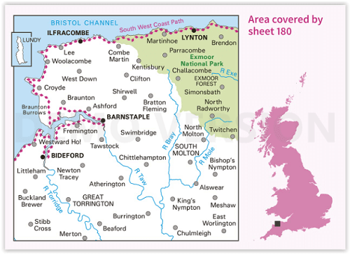
Productbeschrijving: Kaart nummer 180 is een all purpose kaart vol gepakt met informatie om u het gebied te helpen leren kennen. De 204 Landranger-kaarten bestrijken het land. Elke kaart heeft een oppervlakte van 40 km door 40 km (25 mijl door 25 mijl) en zoals andere kaarten van Ordnance Survey, National Grid-vierkanten worden verstrekt zodat elke functie een unieke referentienummer kan worden gegeven. Barnstaple is een plaats (town) in het bestuurlijke gebied North Devon, in het Engelse graafschap Devon.
Productdiscription: The OS Landranger Active Map series covers Great Britain with 204 detailed maps, perfect for day trips and short breaks. Tough, durable and weatherproof, covered in a lightweight protective plastic coating that can be written on, so that your favourite routes can be easily highlighted. Each map provides all the information you need to get to know your local area and includes places of interest, tourist information, picnic areas and camp sites, plus Rights of Way information for England and Wales. OS Landranger Active now includes a digital version of the paper map, accessed through the OS smartphone app, OS Maps.
Locatie op kaart
Overzichtskaarten

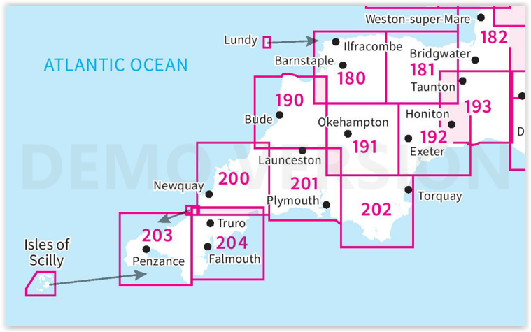
OSI Landranger & Landranger Active - Land's End - Devon - Cornwall
OSI Landranger & Landranger Active - Land's End - Devon - Cornwall
Producten op de overzichtskaart
Klik op een product om naar de detailpagina te gaan.
- Wandelkaart 180 Barnstable & Ilfracombe- Devon England - OSI
- Wandelkaart 180 Barnstaple & Ilfracombe- Devon England - OSI
- Wandelkaart 181 Minehead & Brendon Hills- England - OSI
- Wandelkaart 181 Minehead & Brendon Hills- England - OSI
- Wandelkaart 182 Weston-super-Mare & Bridgwater- England - OSI
- Wandelkaart 182 Weston-super-Mare- Somerset England - OSI
- Wandelkaart 190 Bude & Clovelly- Cornwall England - OSI
- Wandelkaart 190 Bude- Clovelly & Boscastle - OSI
- Wandelkaart 191 Okehampton & North Dartmoor NP - OSI
- Wandelkaart 191 Okehampton & North Dartmoor NP - OSI
- Wandelkaart 192 Exeter & Sidmouth- Devon - OSI
- Wandelkaart 192 Exeter- Sidmouth & Exmouth - OSI
- Wandelkaart 193 Taunton & Lyme Regis- England - OSI
- Wandelkaart 193 Taunton & Lyme Regis- Somerset - OSI
- Wandelkaart 200 Newquay- Bodmin & Camelford - OSI
- Wandelkaart 200 Newquay & Bodmin Cornwall - OSI
- Wandelkaart 201 Plymouth & Launceston England - OSI
- Wandelkaart 201 Plymouth & Launceston England - OSI
- Wandelkaart 202 Torbay - South Dartmoor NP - OSI
- Wandelkaart 202 Torbay & South Dartmoor - OSI
- Wandelkaart 204 Truro- Falmouth & Roseland - OSI
- Wandelkaart 204 Truro & Falmouth- Cornwall England - OSI
- Wandelkaart 203 Land's End & Isles of Scilly - OSI
- Wandelkaart 203 Land's End & Isles of Scilly - OSI
Artikelen uit dezelfde regio

The beauty of North Devon UK - Goldeneye • 9781859652190
The beauty of North Devon UK Productomschrijving: De tweede van een nieuwe serie van souvenirboeken. Een aandenken voor de duizenden die jaarlijks een bezoek brengen aan Noord-Devon, de Cotswolds, Cornwall en het Lake District. Alle populaire vakantie- en weekendbestemmingen, en voor de vele die gebieden bezoeken, is deze fotoboekserie een speciaal cadeau of souvenir, tegen een redelijke p…

Wandelkaart 111 Bude- Boscastle & Tintagel- Devon - OSI • 9780319243121
Wandelkaart Bude- Boscastle & Tintagel - Devon - OSI Productomschrijving: 111 / Bude, Boscastle & Tintagel, Devon, England - Kaart nummer 111 in de reeks OS Explorer is de perfecte kaart te gebruiken om te wandelen, fietsen of om te kamperen in- en rond Bude, Boscastle en Tintagel. Alle drie de plaatsen kunnen worden bezocht langs de South West Coast Path. Hoogtepunten van het gebied zijn …

Reisgids Exploring Devon - Goldeneye • 9781859652879
Reisgids Exploring Devon - Goldeneye Productomschrijving: Inclusief de Dartmoor & Exmoor Nationale parken - 2e Editie - Dit boek is anders. Het is een onafhankelijke stem, omdat alle inzendingen zijn gekozen op basis van verdienste en verdienste alleen. In een digitaal tijdperk waar (reis) informatie wordt verstrekt door reclame budgetten. Hierbij een verfrissende en verhelderende kijk op …

Wandelkaart 139 Bideford & Ilfracombe- Devon - OSI • 9780319243329
Wandelkaart Bideford- Ilfracombe & Barnstaple - Devon England Productbeschrijving: - Woolacombe & Lundy. 139 / Bideford, Ilfracombe & Barnstaple, Devon, England - Kaart nummer 139 in de OS Explorer reeks omvat Ilfracombe, Bideford, Barnstaple, Westward Ho!, Woolacombe, en Lundy Island, en laat een deel van de South West Coast Path zien. De OS Explorer kaart voor Bideford, Ilfracombe & …

Wandelkaart XT25 Exmoor NP Devon England - Harvey maps • 9781851376858
Wandelkaart Exmoor Nqtional Park - Harvey maps Productomschrijving: Meer dan een kaart - een essentieel stuk gereedschap. Deze nieuwe generatie HARVEY Superwalker is ontworpen om het meest praktische hulpmiddel te zijn voor navigatie buitenshuis. - Het hele Exmoor National Park op één blad - Bestrijkt Combe Martin in het westen, Minehead aan de noordkust en Exebridge in het zuiden …