

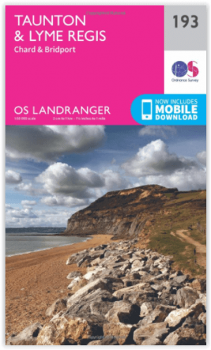
Wandelkaart 193 Taunton & Lyme Regis- Somerset - OSI
Omvat delen van Devon- Dorset & Somerset


Korte omschrijving
Wandelkaarten Somerset South West England van Ordnance Survey. Ideaal voor tochten in England.
Wandelkaart Taunton & Lyme Regis - Somerset England Productbeschrijving: OS Landranger kaart 193 toont delen van Devon, Dorset en Somerset, met inbegrip van de populaire vakantiebestemmingen...

Specificaties
- Uitgever: Ordnance Survey
- ISBN-13: 9780319262917
- HOOFDCATEGORIEËN: Wandelkaart
- Activiteiten: Wandelen, Hiking & Trekking
- Regio: Somerset South West England
- Land: England
- UNESCO werelderfgoed: Dorset & East Devon Coast, England UK
- TOPO's & Stafkaarten: Topografisch wandelen
- Schaal: 1:50000
- Taal: Engels
- Reeks/Serie: Landranger Series OSI
- De Engelse Graafschappen: Somerset
Volledige omschrijving
Wandelkaart Taunton & Lyme Regis - Somerset England
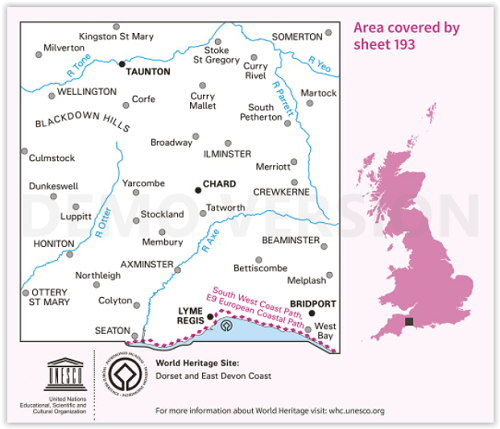
Productbeschrijving: OS Landranger kaart 193 toont delen van Devon, Dorset en Somerset, met inbegrip van de populaire vakantiebestemmingen steden van Taunton, Lyme Regis en Honiton. Leuke dingen om te zien de stad molen in Lyme Regis, opnemen met een waterrad werkende hersteld.
De OS Landranger kaarten reeks heeft betrekking op Groot-Brittannië met 204 gedetailleerde kaarten, perfect voor dagtochten en korte pauzes. Elke kaart bevat alle informatie die u nodig heeft om dit lokaal gebied te leren kennen en omvat plaatsen van belang, toeristische informatie, picknickplaatsen en campings, plus doorgangsrechten informatie voor Engeland en Wales.
Productdiscription: OS Landranger map 193 shows parts of Devon, Dorset and Somerset, including the popular holiday towns of Taunton, Lyme Regis and Honiton. Fun things to see include the Town Mill in Lyme Regis, with a working restored waterwheel.
The OS Landranger Map series covers Great Britain with 204 detailed maps, perfect for day trips and short breaks. Each map provides all the information you need to get to know your local area and includes places of interest, tourist information, picnic areas and camp sites, plus Rights of Way information for England and Wales.
Locatie op kaart
Gekoppelde artikelen
Wandelkaart 193 Taunton & Lyme Regis- Somerset - OSI • 9780319262917
standaard versieWandelkaart Taunton & Lyme Regis - Somerset England Productbeschrijving: OS Landranger kaart 193 toont delen van Devon, Dorset en Somerset, met inbegrip van de populaire vakantiebestemmingen steden van Taunton, Lyme Regis en Honiton. Leuke dingen om te zien de stad molen in Lyme Regis, opnemen met een waterrad werkende hersteld. De OS Landranger kaarten reeks heeft betrekking op Groot-…
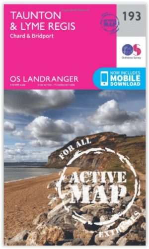
Wandelkaart 193 Taunton & Lyme Regis- England - OSI • 9780319475164
weatherproof versieWandelkaart Taunton & Lyme Regis - Somerset England Productbeschrijving: OS Landranger kaart 193 toont delen van Devon, Dorset en Somerset, met inbegrip van de populaire vakantiebestemmingen zoals de steden van Taunton, Lyme Regis en Honiton. Leuke dingen om te zien de stad molen in Lyme Regis, opnemen met een waterrad werkende hersteld. De OS Landranger kaarten reeks heeft betrekking …
Overzichtskaarten

Artikelen met UNESCO Werelderfgoed locaties
Artikelen met UNESCO Werelderfgoed locaties

Producten op de overzichtskaart
Klik op een product om naar de detailpagina te gaan.
- Wandelkaart 10047 - Aurland- Sogn og Fjordane - Nordeca AS
- Fietsgids - A vélo en Ardèche méridionale - 46 balades - Glénat
- Wandelkaart XT25 - Yorkshire Dales Zuid-Oost - Harvey maps
- Wandelkaart XT40 - N.O. Yorkshire Dales NP - Harvey ultramaps
- Wandelkaart XT40 - N.W. Yorkshire Dales NP - Harvey Ultramaps
- Wandelkaart XT40 - Z.O. Yorkshire Dales England - Harvey Maps
- Wandelkaart XT40 - Z.W. Yorkshire Dales - Harvey Ultramaps
- Wandelkaart 3713 ET - Pays de Bitche & PNR des Vosges du Nord
- Fietsgids - Canal du Midi cycling - Cicerone
- Fietsgids Bedevaart Ruta Via de la Plata cycle route - Cicerone
- Wandelgids - Italy's Cinque Terre walking - Cicerone
- Wandelkaart 204 Truro & Falmouth- Cornwall England - OSI
- Wandelkaart 0/16 - Mount Kenya Nationalpark - Alpenverrein
- Wandelgids Tour of the Jungfrau - Cicerone
- Wandelkaart Geopark Harz - Braunschweiger Land - Huber
- Wandelkaart XT25 - Yorkshire Dales NP Noord-Oost - Harvey maps
- Wandelkaart - South West Coast Path 5 - Harvey maps
- Wandelgids - Ostfriesland Duitsland - Rother
- Fietskaart & wandelkaart 368 - Rhein Radweg 3 - Publipress
- Wandelgids & klimgids - Berner Alpen 4- Jungfrau Region - SAC
- Wandelkaart - Hadrian's Wall Path - Harvey maps
- Wandelkaart - South West Coast Path 1 - Harvey maps
- Wandelkaart - South West Coast Path 3 - Harvey maps
- Wandelkaart - South West Coast Path 4 - Harvey maps
- Wandelkaart - South West Coast Path 6 - Harvey maps
- Wandelkaart XT25 - Yorkshire Dales Zuid-West - Harvey Maps
- Wandelkaart 194 - Dorchester & Weymouth- Dorset - OSI
- Wandelkaart 179 - Canterbury- East Kent - England - OSI
- Wandelkaart 195 - Bournemouth & Purbeck- SW England - OSI
- Wandelkaart 193 - Taunton & Lyme Regis- Somerset - OSI
- Wandelkaart 2241 SB - Albi & Cordes-sur-Ciel - IGN
- Wandelkaart 179 - Canterbury & East Kent - England - OSI
- Wandelkaart 247t - Sardona Graubünden - Swisstopo
- Fietsgids Bikeline - Neusiedler See - Radweg - Estenbauer
- Wandelgids - Massif Central (week-end) à pied - Ed. Chamina
- Wandelkaart 2137 SB - Gramat & Rocamadour - IGN
- Compostelle en France nouveaux chemins- Ed.Ouest France
- Wandelkaart 2138 OT - Cahors & St-Cirq-Lapopie - IGN

OSI Landranger & Landranger Active - Land's End - Devon - Cornwall
OSI Landranger & Landranger Active - Land's End - Devon - Cornwall
Producten op de overzichtskaart
Klik op een product om naar de detailpagina te gaan.
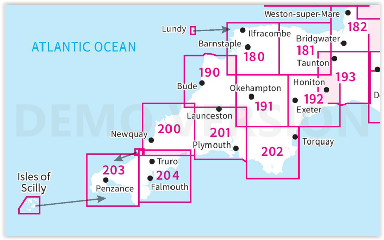
- Wandelkaart 180 Barnstable & Ilfracombe- Devon England - OSI
- Wandelkaart 180 Barnstaple & Ilfracombe- Devon England - OSI
- Wandelkaart 181 Minehead & Brendon Hills- England - OSI
- Wandelkaart 181 Minehead & Brendon Hills- England - OSI
- Wandelkaart 182 Weston-super-Mare & Bridgwater- England - OSI
- Wandelkaart 182 Weston-super-Mare- Somerset England - OSI
- Wandelkaart 190 Bude & Clovelly- Cornwall England - OSI
- Wandelkaart 190 Bude- Clovelly & Boscastle - OSI
- Wandelkaart 191 Okehampton & North Dartmoor NP - OSI
- Wandelkaart 191 Okehampton & North Dartmoor NP - OSI
- Wandelkaart 192 Exeter & Sidmouth- Devon - OSI
- Wandelkaart 192 Exeter- Sidmouth & Exmouth - OSI
- Wandelkaart 193 Taunton & Lyme Regis- England - OSI
- Wandelkaart 193 Taunton & Lyme Regis- Somerset - OSI
- Wandelkaart 200 Newquay- Bodmin & Camelford - OSI
- Wandelkaart 200 Newquay & Bodmin Cornwall - OSI
- Wandelkaart 201 Plymouth & Launceston England - OSI
- Wandelkaart 201 Plymouth & Launceston England - OSI
- Wandelkaart 202 Torbay - South Dartmoor NP - OSI
- Wandelkaart 202 Torbay & South Dartmoor - OSI
- Wandelkaart 204 Truro- Falmouth & Roseland - OSI
- Wandelkaart 204 Truro & Falmouth- Cornwall England - OSI
- Wandelkaart 203 Land's End & Isles of Scilly - OSI
- Wandelkaart 203 Land's End & Isles of Scilly - OSI
Artikelen uit dezelfde regio
Wandelgids The Cotswold Way Map Booklet - Cicerone • 9781786312112
The Cotswold Way - Cicerone Productomschrijving: OPGELET: Dit artikel is reeds inbegrepen in de volledige wandelgids van de The Cotswold Way. Deze kunt u vinden met dit ISBN nr in te geven in onze zoekfunctie: 9781786312105 - Het boek gaat over de befaamde Cotswold Way, tussen Chipping Camden en Bath, dwars door het Cotswolds AONB regio van uitmuntend natuurschoon. 164 km lange route in 2…

Reisgids Cotswolds Top 10 - William Fricker - Goldeneye • 9781859653081
Reisgids Cotswolds - Goldeneye Productomschrijving: Ervaren Cotswold-reisschrijver William Fricker en zijn team van Goldeneye geven hun mening over de mooiste dorpen om te bezoeken. Een breed scala aan activiteiten om aan deel te nemen, van het bezoeken van landhuizen en tuinen, de prachtige kerken en de dromerige rivierdalen. Een breed scala aan overnachtingsmogelijkheden, van landelijke …
Reisgids Cotswolds England - Rough Guides • 9780241308752
Reisgids Cotswolds England - Rough Guides Productomschrijving: The Rough Guide to the Cotswolds AONB is your definitive handbook to one of the most beautiful and diverse holiday destinations in the UK. From stately homes and wildlife parks to modern art galleries, country walks and adventure sports, there is a section that introduces all of the regions’ highlights. For every town and v…
Wandelgids Day Walks in the Cotswolds AONB - Vertebrate Publ. • 9781910240991
Day Walks in the Cotswolds AONB - Vertebrate Productomschrijving: Day Walks in the Cotswolds by Judy Mills features 20 circular routes suitable for hillwalkers of all abilities. Together with stunning photography, each route features Ordnance Survey 1:25,000 maps, easy-to-follow directions, distance and navigation information, refreshment stops and local information. Split across thre…

Wandelkaart 128 Taunton & Blackdown Hills Somerset - OSI • 9780319243244
Wandelkaart Taunton & Blackdown Hills - Somerset England Omvat ook: Wellington & Ilminster. Productbeschrijving: Omvat de Blackdown Hills, alsook het Oosten en het westen van de Deane Way. Deze OS Explorer kaart nummer 128 is het ideale hulpmiddel voor het verkennen van de steden rond Taunton, Wellington, Ilminster en de omliggende dorpen. De OS Explorer kaart voor Taunton & Blackdown …