

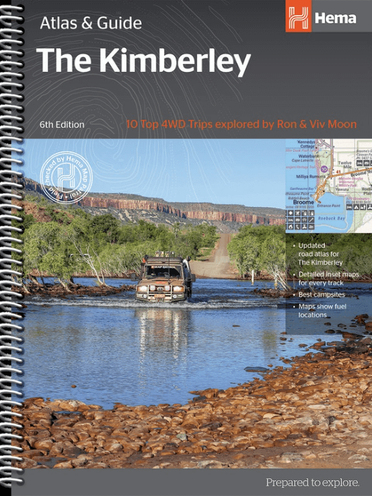
Wegenatlas The Kimberley atlas & guide - Hema Maps
10 x 4WD trips, explored and revised by Ron and Viv Moon
Korte omschrijving
The Kimberley atlas & guide - Hema Productomschrijving: TOP 10 4WD Trips explored by RON And VIV MOON. This brand new edition of Hema’s best-selling outdoor guidebook for discovering th...

Specificaties
- Uitgever: Hema Maps
- ISBN-13: 9781876413644
- HOOFDCATEGORIEËN: Wegenatlas
- Activiteiten: Road atlases & maps, Street/Road maps & city plans, Toerisme
- Auteur: Ron Moon, Viv Moon
- Regio: Western Australia
- Land: Australië
- Editie: 6
- Taal: Engels
- Reeks/Serie: Wegenatlassen
Volledige omschrijving
The Kimberley atlas & guide - Hema
Productomschrijving: TOP 10 4WD Trips explored by RON And VIV MOON.
This brand new edition of Hema’s best-selling outdoor guidebook for discovering the Kimberley now features 20 atlas pages in a stunning new cartographic style. The book features 10 4WD trips, explored and revised by well-known travel writers Ron and Viv Moon.
This edition also now incorporates content from their popular The Kimberley Travel & Adventure Guide. Also included is an introduction to the region, as well as information sections on planning the trip and what to see and do.
PRODUCT FEATURES:
- Handy atlas for navigation
- 10 top 4WD trips featured
- Detailed maps throughout
- Maps show fuel locations
- Trip planning tips
- When to go and how to prepare
- Where to stay and best campsites
- Listings of tour operators
- Background reading on the region
WHAT’S NEW IN THIS EDITION:
- All new cartography
- Clear, easy-to-read style
- 188 new maps
- Featuring more detail for popular coastal areas
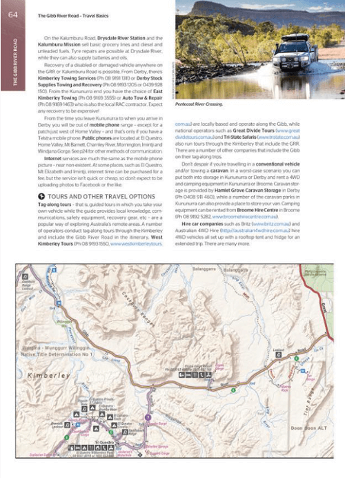
TOP 10 4WD TRIPS: Each track description offers detailed directions and explainations about you'll find along the way. They also include an inset map displaying distances, campsites, facilities and points of interest. Included is information on distances and the time it should take to complete track.
ROAD ATLAS
- Explored by the Hema Map Patrol
- Revised & updated
- From Hema's popular The Kimberley map

Artikelen uit dezelfde regio
Landkaart Wegenkaart Explorer Map Nullarbor Plain - Western Map • 9781925625981
Explorer Map Nullarbor Plain Western Map - Hema Productomschrijving: This map is part of Hema's new Nullarbor Plain Map Series and covers the area from Kalgoorlie to Border Village and its surrounds. Truly one of the worlds great adventure drives, Australia's semi-arid Nullarbor Plain stretches some 1,256 kilometres (781 miles) via the Eyre Highway and links the cities of Adelaide and…
Landkaart Wegenkaart West & Zuidwest-Australië NP's - Hema • 9321438001621
Landkaart West & Zuidwest-Australië - Hema Productomschrijving: A regional map for discovering South West & Western Australia (WA). On the reverse side of the map are detailed inset maps of Nambung National Park, Avon Valley National Park, Lane Poole Reservation, the South West Corner, Stirling Range National Park, D'Entrecastreaux National Park and Albany Coast. Also included is tourist …
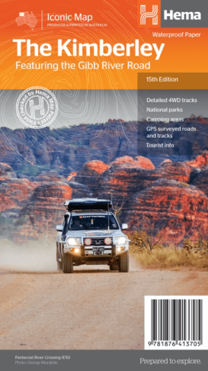
Landkaart Wegnkaart Kimberley Iconic Map, Gibb River road - Hema • 9781876413705
Wegnkaart Kimberley Iconic Map, The Gibb River road Productomschrijving: Een 660 km lange prachtige avontuurlijke route genaamd, The Kimberley Gibb River road. Engelse omschrijving: A regional map of the Kimberley that features the iconic Gibb River Road. On the reverse are inset maps for Purnululu National Park, the Dampier Peninsula and the Parry Creek area. There is also extensive …

Landkaart Wegenkaart West & Midden-Westen Australië NP's - Hema • 9321438002109
Landkaart West & Midden-Westen Australië - Hema Produductomschrijving: A regional map of Mid West Western Australia that covers from Cape Range National Park south to Mandurah and as far as Kalgoorlie at a scale of 1:1,250,000 that has camping areas, national parks, fuel supplies and facility symbols marked on the map. On the reverse is region-specific touring information for Wildflower c…
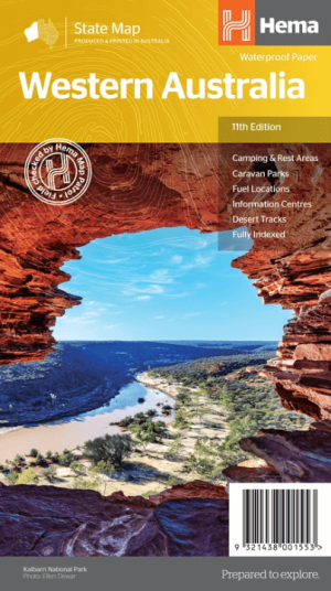
Landkaart Wegenkaart West-Australië state map - Hema Maps • 9321438001553
Wegenkaart West-Australië state map - Hema Productomschrijving: A map of Western Australia (WA) for touring throughout the state that has camping and rest areas, 24-hour fuel and points of interest marked on the mapping. On the reverse are CBD and through road maps of Perth in addition to inset maps of Leeuwin-Naturaliste National Park, Cape Range National Park, Nambung National Park, …