

HOOFDCATEGORIEËN
Activiteiten
Continent
Land
Regio
Schaal
Taal
Reeks/Serie:
Uitgever:
De Australische Regio's
De Franse Regio's
De Griekse Eilanden
De Italiaanse Meren
De Italiaanse Regio's
De Scandinavische Landen
De Spaanse Regio's
Uitgever

 Wegenatlassen per land kiezen
Wegenatlassen per land kiezen,
Een wegenatlas lijkt simpel. Tot je in een boekwinkel staat met 14 varianten en nul context. Daarom werkt “per land” het best: je vertrekt van je bestemming, niet van een merk. Een goede wegenatlas geeft je overzicht én detail in één boek. Je ziet snelwegen, regionale wegen, toeristische trajecten, afstandstabellen en vaak ook een index met plaatsnamen. Dat laatste is goud waard als je niet elke afslag aan een scherm wil uitbesteden.
Gebruik een wegenatlas vooral als je routes wil plannen en onderweg wil kunnen bijsturen. Je markeert je traject, je ziet alternatieven, en je snapt meteen hoe regio’s aan elkaar hangen. Combineer je atlas met een goede wegenkaart als je dieper inzoomt op één streek. Op Bibliotrek start je logisch bij de pagina Wegenkaarten en klik je door naar je land. Voor snelle keuzes helpen landpagina’s ook: België, Frankrijk of Nederland.
Slim kiezen doe je zo: kijk naar dekking (heel land of regio), leesbaarheid, schaal, extra’s (stadsplannen, tolwegen, veerverbindingen) en actualiteit. Reis je met auto.

Stadsgids Dublin official city & district street guide - OSI • 9781908852847
Dublin official city & district street guide - OSI Productomschrijving: Dublin City and District Street Guide features include schematic maps of all major motorway junctions, and enlarged city centre map and 12 major town maps. Updated information and indexed lists of Hospitals, Embassies and Industrial Estates. Transport information for all main Bus and Rail routes. - Enlarged city c…

Wegenatlas Latgale Letland Oost - Jana Seta Publ. • 9789984077055
Wegenatlas Latgale Letland Oost - Jana Seta Publ. Productomschrijving: The most important complementation of the second edition of map series “With a map in nature” is information about nature trails in each of regions. With more than 60 nature trails it is the most complete edition and is made together with experts from dodies. Information about each trail consists of its description, de…
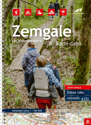
Wegenatlas Zemgale Letland Zuid - Jana Seta Publ. • 9789984077031
Wegenatlas Zemgale Letland Zuid - Jana Seta Productomschrijving: In this series have topography shown with colouring and/or graphics for orchards, forests, swamps, etc; boundaries of national parks and other protected area are clearly marked. The mapping provides a very detail presentation of the road network, from main roads to “difficult to travel” unsurfaced local roads. Locations …

Wegenatlas Letland Baltische staten - Jana Seta Publ. • 9789984077741
Wegenatlas Letland - Jana Seta Publ. Productomschrijving: The Great Atlas of Latvia is the latest collection of maps about the territory of Latvia. Spanning nearly 400 pages, the atlas presents the entirety of Latvia on a scale of 1:80,000. One of its greatest values lies in the precise depiction of Latvia’s territory. Additionally, the atlas includes detailed plans for 45 Latvian cities …

Reisgids Wegenatlas landkaart Bretagne (Franstalig) - Expressmap • 9788383554204
Reisgids Wegenkaart landkaart Bretagne - Expressmap Productomschrijving: Cette région entre terre et mer saura satisfaire tous les goûts touristiques. Les vestiges mégalithiques dans le golfe du Morbihan, les fières cités aux racines médiévales, où nichent des maisonnettes coquettes à pans de bois. Les sculptures dans les enclos paroissiaux, qui témoignent de la ferveur religieuse des Bret…

Wegenatlas USA, Canada & Mexico 2026 -2027 Ringband & A4 - F&B • 9783707924435
Wegenatlas USA, Canada & Mexico, in Ringband & op A4 formaat Productomschrijving: De USA - Canada - Mexico, autoatlas 1:400.000 - 1:16.000.000 is de ideale reisgenoot voor iedereen die met de auto of camper door Noord-Amerika reist. Het is ideaal voor planning en blijkt ook een onmisbaar oriëntatiehulpmiddel tijdens het reizen. De schaal van de kaart varieert afhankelijk van de staat. Mex…
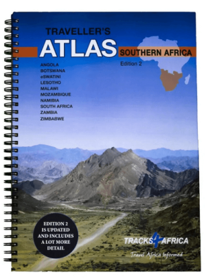
Wegenatlas Southern Africa - Slingsby Maps • 9780994720870
Wegenatlas Southern Africa - tracks 4 Afrika Productomschrijving: The Atlas is printed in A3 size, weighs 2.75kg, has a hard laminated cover, ring bound for ease of use and printed on thicker than normal paper to ensure durability. This Atlas covers ten countries in Southern Africa and is specifically aimed at self-drive travellers. The countries included are: Angola, Botswana, Lesotho, M…

Recreational Atlas of Australia - UBD Gregory's • 9780731927982
Recreational Atlas of Australia - UBD Productomschrijving: Bevat gebruiksvriendelijke, grootschalige kaarten -- 58 pagina's met informatie over diverse recreatieve activiteiten -- Pictogrammen die de populairste bestemmingen voor recreatieve activiteiten op de kaarten aangeven -- Kleurenfoto's -- Uitgebreide index.

Wegen Atlas Griekenland Centraal - Anavasi Ed. • 9789609824927
WegenatlasCentraal Griekenland - Anavasi Productomschrijving: Road Atlas of Attika, the region around Athens, and Central Greece from Anavasi, in an A4 paperback format, with contoured mapping at 1:50,000, a 2km UTM grid for GPS users, very detailed road classification, hiking paths, and place names in both Greek and Latin alphabets. The main section of the atlas has 219 pages of deta…
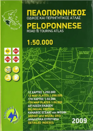
Wegenatlas Peloponnesos Griekeland - Anavasi Ed. • 9789609824910
Wegenatlas Peloponnesos - Anavasi productomschrijving: The main section of the atlas has 178 pages of detailed maps with contours at 100m intervals, altitude colouring and relief shading to provide a vivid representation of the terrain. Nearly all names: town and villages, geographical features, etc, are given in both Greek and Latin alphabets, with just minor local churches shown in Gree…

Wegen- & pocket atlas Rome - TCI • 9788836563937
Wegen- & pocket atlas Rome - TCI Productomschrijving: Ontdek Italië met deze Pocket atlas voor de wereldstad Rome van Touring Club Editore! - De gids is in het Engels en het Italiaans. Busservice van - en naar de luchthaven 7 op 7 dagen beschikbaar, ofwel net wuiten de aankomsthal Rechts buiten, of in de andere richting naar de luchthaven, te vinden aan de zijkant van het treinstation van …

Wegenatlas Italië Atlante stradale e Turistico 2025/2026 - TCI • 9788836582785
Wegenatlas Italië - TCI Productomschrijving: Ontdek Italië met de regionale wegenkaarten van Touring Club Editore! - De kaarten zijn in het Engels en het Italiaans. Voor wie Italië écht wil ontdekken, zijn de regionale wegenkaarten van Touring Club Editore onmisbaar. Deze gedetailleerde kaarten bieden een helder overzicht van elke regio, van de Alpen tot Sicilië. Dankzij de nauwkeurige…

Autogids Groot-Brittanië - Uitgeverij Lannoo • 9789020905342
Autogids Groot-Brittanië - Uitgeverij Lannoo Productomschrijving: Lonely Planet laat je actief genieten van het mooiste van Groot-Brittannië. Ontdek Groot-Brittannië op een actieve manier met deze kant-en-klaar uitgestippelde routes van Lonely Planet. Je kiest uit panoramatochten, kustroutes, bergritten, gastronomische circuits en wildlife tours. Tips voor de beste reistijd en de ultieme …
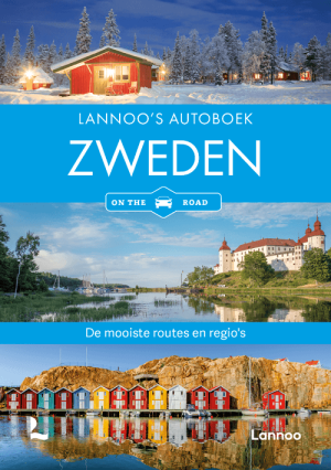
Lannoo's Autoboek Zweden on the road - Uitgeverij Lannoo • 9789020927511
Lannoo's Autoboek Zweden on the road - Lannoo Productomschrijving: Lannoo's autoboeken 'on the road' zijn praktische gidsen om een land of regio met de auto te verkennen. Ze bevatten uitgestippelde routes met praktische informatie over reistijd, restaurants, hotels en bezienswaardigheden onderweg. Je kunt de voorgestelde routes overnemen of op een persoonlijke manier met elkaar combineren.…

Reisgids Roadtrips in Europa - Mo'media • 9789493338753
Roadtrips in Europa - Mo'media Productomschrijving: Reizen zonder haast en allesbepalende planning: een roadtrip betekent vrijheid om Europa in je eigen tempo te verkennen. Op weg naar bijzondere plekken kun je uitstappen waar en wanneer je maar wilt. Tijdens het rijden geniet je van het uitzicht, zie je het landschap veranderen en verruim je je blik op de wereld. Ga naar de fjorden in Ijs…

Wegenatlas Top End, Golf Atlas & Guide - Hema Maps • 9781922668943
Wegenatlas Top End, Golf Atlas & Guide - Hema Productomschrijving: Top End and Golf Atlas & Atlas & Guide hema 1/125000 Deze gids biedt uitgebreide en up-to-date informatie over de hele Top End en Golf regio, met Darwin en de Tiwi eilanden; Kakadu, Litchfield, Nitmiluk, Judbarra-Gregory, Limmen en Boodjamulla (Lawn Hill) National Parks: Arnhem Land, de Golfkust en Barkly Tableland.…

Wegenatlas Italië, Atlante stradale 2025/26 - TCI • 9788836583195
Wegenatlas Italië 2025/26 - TCI Productomschrijving: Het is de Touring Atlas bij uitstek, de meest verspreide, gemakkelijk en onmiddellijk te gebruiken! Verdeeld in 3 volumes, is deze essentieel voor het plannen van reizen door heel Italië, om de grote en kleine schatten en de mooiste panoramische wegen te ontdekken. De Volumes bevatten: • Snelwegprofielen met alle service-inform…

Wegenatlas Italy North 2026/27 - Atlante stradale Nord - TCI • 9788836583164
Wegenatlas noord Italy - TCI Productomschrijving: Het is de Touring Atlas bij uitstek, de meest verspreide, gemakkelijk en onmiddellijk te gebruiken! Verdeeld in 3 volumes, is deze essentieel voor het plannen van reizen door heel Italië, om de grote en kleine schatten en de mooiste panoramische wegen te ontdekken. De Volumes bevatten: • Snelwegprofielen met alle service-informat…

Wegenatlas Italy Central 2026/27, Atlante stradale Centro - TCI • 9788836583171
Wegenatlas Centraal Italy - TCI Productomschrijving: Productomschrijving: Het is de Touring Atlas bij uitstek, de meest verspreide, gemakkelijk en onmiddellijk te gebruiken! Verdeeld in 3 volumes, is deze essentieel voor het plannen van reizen door heel Italië, om de grote en kleine schatten en de mooiste panoramische wegen te ontdekken. De Volumes bevatten: • Snelwegprofielen me…
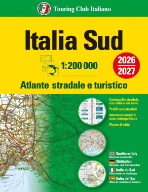
Wegenatlas Italy South 2026/27 - Atlante stradale Sud - TCI • 9788836583188
Wegenatlas Italy South - Atlante stradale Sud - TCI Productomschrijving: Het is de Touring Atlas bij uitstek, de meest verspreide, gemakkelijk en onmiddellijk te gebruiken! Verdeeld in 3 volumes, is deze essentieel voor het plannen van reizen door heel Italië, om de grote en kleine schatten en de mooiste panoramische wegen te ontdekken. De Volumes bevatten: • Snelwegprofielen me…

Wegenatlas Britain & Ireland road atlas - Harper Collins • 9780008779047
Wegenatlas Britain & Ireland - Harper Collins Productomschrijving: This easy-to-use, handy A5 sized road atlas with popular lie-flat spiral binding features extremely clear route planning maps of Britain and Ireland and fits neatly into your glove box or bag. The atlas has been fully updated. The maps of Britain are at 9.9 miles to 1 inch (1:625,000) and the whole of Ireland is covered at …

Wegenatlas Italië Grote Wegenatlas - Fretytag & Berndt • 9783707924527
Grote Wegenatlas Italië - Fretytag & Berndt Duitse Productomschrijving: Der Straßenatlas Italien 1:150.000 ist der richtige Begleiter für alle Urlauber die Italien mit dem Auto entdecken und das Dolce Vita auch links und rechts der Autobahn kennenlernen wollen. Er ist ideal für die Planung und erweist sich auch während der Reise als unverzichtbare Orientierungshilfe. Mit dem detaillier…

Wegenatlas Zweden 2026 - Kartförlaget • 9789198980110
Wegenatlas Zweden 2026 - Kartförlaget Productomschrijving: De M Vägatlas Sverige 2026 van Kartförlaget is een praktische wegenatlas voor iedereen die Zweden met de auto, camper of motor wil doorkruisen. Deze atlas bundelt duidelijke wegenkaarten met nuttige reisinformatie, zodat je niet alleen de hoofdwegen vindt, maar ook kleinere routes, afstanden en interessante stops onderweg beter kun…
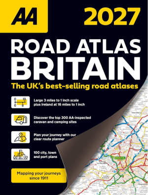
Wegenatlas Britain Road Atlas 2027 - AA Road Maps • 9780749584566
Britain Road Atlas 2027 - AA Road Maps Productomschrijving: This top-selling road atlas showcases Britain’s clearest mapping from the experts at the AA. Each page has been titled with its geographical location so you can turn to the page you need more easily. Wide and narrow minor roads, National Trust, English and World Heritage sites and hard-to-find places are shown. There are 112 city…

Wegenatlas Kroatië & Slovenië - Freytag & Berndt • 9783707924633
Wegenatlas Kroatië & Slovenië - Freytag & Berndt Productomschrijving: De autoatlas Kroatië - Slovenië op schaal 1:150.000 is de ideale metgezel voor iedereen die met de auto onderweg is en niet alleen de hoofdwegen en snelwegen wil gebruiken. Hij is ideaal voor het plannen van uw reis en blijkt ook tijdens de reis een onmisbaar hulpmiddel te zijn om de weg te vinden. Met de gedetailleerde …
Stadsnavigatie zonder stress
Stadsnavigatie zonder stress,
In steden faalt digitale navigatie het hardst. Beton, tunnels, omleidingen, lage-emissiezones, parkeerlogica uit de hel. Een wegenatlas helpt je tot aan de stadsrand. Daarna wil je een duidelijke stadskaart of plattegrond. Je ziet in één oogopslag ringwegen, invalswegen, wijken, stations en belangrijke bezienswaardigheden. Je plant waar je parkeert. Je vermijdt eindeloze rondjes rijden alsof dat een hobby is.
Daarom zet je op één pagina best een brug tussen “wegen” en “stad”: je start met de wegenatlas voor de aanloop, en je schakelt over op een stadskaart voor het laatste stuk. Bibliotrek heeft hiervoor een aparte rubriek Stadskaarten & Plattegronden waar je per stad of type plan kiest. Wil je naast navigatie ook context (wijken, highlights, praktische info), dan sluit Stadsgidsen & City Guides hier mooi op aan.
Maak het concreet in je tekst: benoem citytrip-situaties (te voet, openbaar vervoer, last-mile), leg kort uit waarom papier werkt (geen batterij, direct overzicht, aantekeningen), en stuur door naar de juiste interne pagina’s. Zo verkoop je geen “nostalgie”. Je verkoopt controle. En dat klikt. Zeker bij mensen die met gezin reizen, met camper rijden, of gewoon geen zin hebben om in een onbekende stad te discussiëren met een telefoon.
Europa roadtrips in één oogopslag
Europa roadtrips in één oogopslag,
Een Europese roadtrip vraagt om schaal. Niet micro-detail, wel overzicht dat klopt. Je wil grenzen, hoofdassen, alternatieve routes, en genoeg context om te snappen waar je tijd wint of verliest. Dat is exact waar wegenatlassen en Europese wegenkaarten samen sterk staan. Je gebruikt de atlas om je grote lijn te kiezen, en je pakt een Europese wegenkaart om snel te schakelen tussen landen en regio’s. Bibliotrek heeft hiervoor een duidelijke hub Europese Wegenkaarten.
Die pagina helpt je vooral als je door meerdere landen rijdt, of als je een regio wil selecteren zonder eindeloos filteren. Vanuit daar blijf je in dezelfde logica: continent, land, regio. En als je breder wil oriënteren (wegenkaarten, stadskaarten, gidsen), dan vormt Wegen- & stadskaarten je startpunt.
Zet in deze sectie de nadruk op beslissingen die mensen echt maken: “rijd ik via kust of binnenland?”, “vermijd ik tol?”, “wil ik panoramische routes?”, “waar plan ik mijn tussenstops?”. Benoem ook waarom papier onderweg beter werkt dan je denkt: je ziet omwegen voordat je erin vastzit. Je ziet opties die een GPS niet toont omdat ze niet ‘optimaal’ zijn. Voor roadtrips is “optimaal” vaak het verkeerde doel. Je wil mooi, logisch, haalbaar.
Deze sectie verkoopt het gevoel van grip. Niet alleen het product. En ja, dat is precies waarom wegenatlassen nog altijd relevant zijn, ondanks alle apps die doen alsof ze je beste vriend zijn.