

Wegenatlas Southern Africa - Slingsby Maps
Second edition atlas is substantially thicker than the first ed.

Korte omschrijving
Wegenatlas Southern Africa - tracks 4 Afrika Productomschrijving: The Atlas is printed in A3 size, weighs 2.75kg, has a hard laminated cover, ring bound for ease of use and printed on thick...

Specificaties
- Uitgever: Tracks4Africa
- ISBN-13: 9780994720870
- HOOFDCATEGORIEËN: Atlassen, Wegenatlas, Wegenkaart - Landkaart
- Activiteiten: Road atlases & maps
- Regio: Zuid Afrika
- Land: Angola, Botswana, Lesotho, Malawi, Mozambique, Namibië, Swaziland, Zambia, Zimbabwe, Zuid-Afrikaansche Republiek (ZAR)
- Editie: 2
- Taal: Engels
- Reeks/Serie: Wegenatlassen
Volledige omschrijving
Wegenatlas Southern Africa - tracks 4 Afrika
Productomschrijving: The Atlas is printed in A3 size, weighs 2.75kg, has a hard laminated cover, ring bound for ease of use and printed on thicker than normal paper to ensure durability. This Atlas covers ten countries in Southern Africa and is specifically aimed at self-drive travellers. The countries included are: Angola, Botswana, Lesotho, Malawi, Mozambique, Namibia, South Africa, Eswatini, Zambia and Zimbabwe.
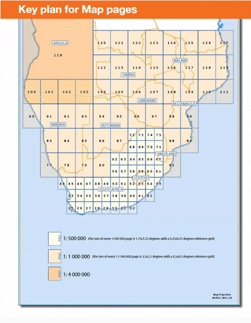
Bigger coverage than ever before:
1:4M maps for Southern and Eastern Africa – ideal for macro planning.
1:1M maps for Southern Africa, covering the following countries: Angola, Botswana, eSwatini, Lesotho, Malawi, Mozambique, Namibia,
South Africa, Zambia and Zimbabwe.
1:500K maps for South Africa, Malawi, most part of Zambia and the area around Moremi/Chobe in Botswana.
This second edition atlas is substantially thicker than the first edition and includes many more pages of detailed maps.
Road coverage:
This Atlas is designed for overland travel and compiled from the same data used on our famous GPS maps. Use it for trip planning or on the road as a companion for your GPS navigation system.
- The detailed road network covers 518 350km.
- All major and secondary routes feature distances and travel times (1:1M and 1:500K maps only).
- Each country page features a table with the times and distances between major towns.
- Vital information needed for planning an extended self-drive trip:
- Per country information includes legal requirements for your vehicle, road conditions, traffic rules, signals used by locals
- Comprehensive information of what you need to transit borders.
- Featuring 127 border posts with opening times.
Valuable information while on the road:
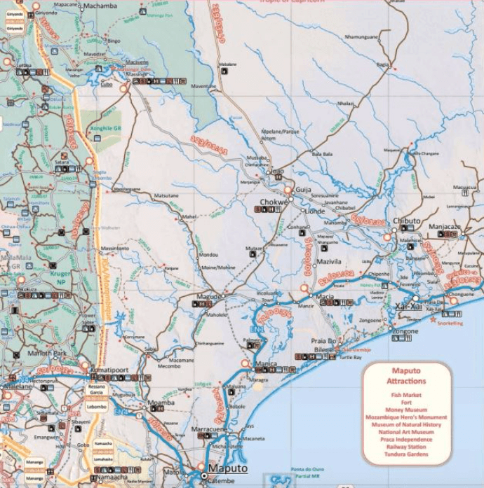
This Atlas is jam-packed with as much detail as possible on protected areas, major and minor attractions, places to stay and activities. You can also see which services like fuel, bank/ATM, shopping, restaurant, hospital, police or auto repair are available in each town. The Atlas features 223 map pages with the same trusted map detail for which Tracks4Africa is renowned.
Map features include:
- Map scales include 1:4000 000, 1:1000 000; 1:500 000
- 518 350km of off-road tracks and major roads.
- Distance and travel time between towns.
- Essential facilities available in towns.
- Camping and lodging.
- Tourist attractions.
- All border crossings, with opening times.
- All international airports, with IATA/ICAO codes.
- Protected areas.
The first section of the Atlas includes valuable travel information about each of the ten countries. The information about border crossings and top tourist attractions will help you to be well-prepared for your trip and the sections on driving conditions will assist you while on the road.

Artikelen uit dezelfde regio
Reisgids South Africa - Lesotho & Eswatini - Rough Guides • 9781839059780
South Africa - Lesotho & Eswatini - Rough Guides Productomschrijving: Ontdek Zuid-Afrika, Lesotho en Swaziland met de meest scherpzinnige en onderhoudende gids op de markt. Of je nu van plan bent om op safari te gaan in het Kruger National Park, de heerlijke wijnen van de Westkaap te proeven of het dorp te verkennen waar Nelson Mandela opgroeide, The Rough Guide to South Africa, Lesotho & …

Landkaart Wegenkaart 60 Namibië - Track4afrika • 9781776322695
Wegenkaart Namibië - Track4afrika Productomschrijving: Kenmerkend voor deze kaart is de combinatie van geografische informatie en GPS verwijzingen, ideaal voor 4x4 routes. Verder bevat de kaart een plaatsnamenregister, aparte kaartjes van de Nationale parken en stadsplannen van de belangrijkste steden uit de regio. Deze kaart bied u het perfecte instrument om uw volgende reis te plann…
Landkaart Wegenkaart SC5 & SC6 George > Kareedouw - Tracks4Afrika • 9781776322763
Wegenkaart SC5 & SC6 George > Kareedouw Productomschrijving: SC5 & SC6 : Garden Route / Baviaanskloof Includes: George, Knysna, Willowmore, Uniondale, Wilderness, Plettenberg Bay, Storms River, Steytlerville and Kareedouw. The Cape to Addo map series covers the southern parts of the Western Cape of South Africa in a series of eight highly detailed maps, printed on four sheets of A…

Landkaart Wegenkaart 3204 Zuid-Afrika - Nat Geo • 9781566955317
Wegenkaart Zuid-Afrika - Nat Geo Productomschrijving: National Geographic's South Africa Adventure Map provides global travelers with the perfect combination of detail and perspective in a highly functional travel tool. Hundreds of points of interest that highlight the diverse, unique, and exotic destinations within the country such as National parks and reserves, Sanctuaries, World Herit…
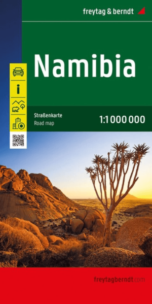
Landkaart Wegenkaart Namibië - Freytag & Berndt • 9783707924749
Wegenkaart Namibië - Freytag & Berndt Productomschrijving: Deze wegenkaart Namibië van Freytag & Berndt is een praktische kaart voor reizigers die Namibië met de auto, camper of 4x4 willen verkennen. Het land vraagt om overzicht: de afstanden zijn groot, de landschappen open en de routes lopen vaak door dunbevolkte gebieden waar een schermpje niet altijd genoeg context geeft. Deze kaart he…