

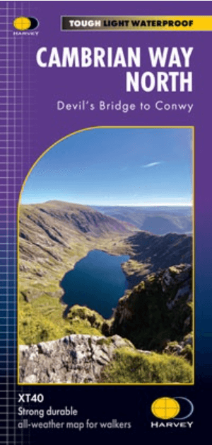
Wandelkaart Cumbrian Way North XT40 - Harvey Maps
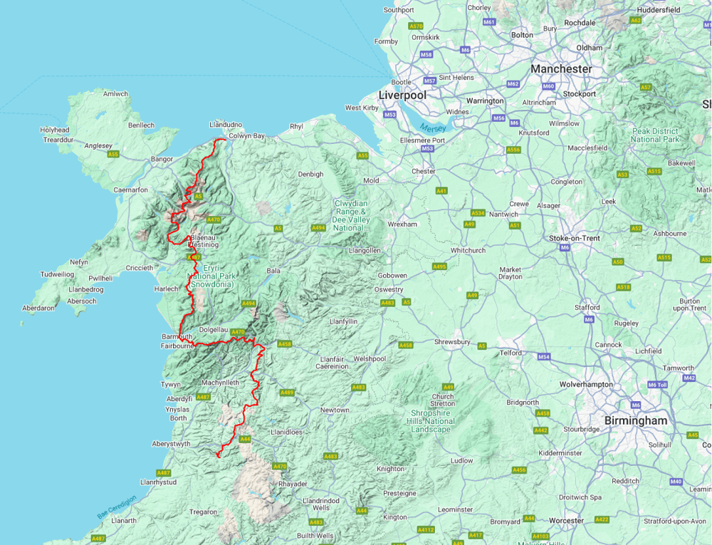
Bannau Brycheiniog National Park - Eryri National Park - 479 km
Korte omschrijving
Wandelkaarten North Wales van HARVEY MAPS. Ideaal voor tochten in Wales.
Wandelkaart Cumbrian Way North - Harvey Maps Productomschrijving: The entire route across two maps, including sections through Bannau Brycheiniog National Park, the Cambrian Mountains and E...

Specificaties
- Uitgever: HARVEY MAPS
- ISBN-13: 9781851376872
- HOOFDCATEGORIEËN: Wandelkaart
- Activiteiten: Wandelen, Hiking & Trekking
- Regio: North Wales
- Land: Wales
- Nationale parken: Brecon Beacons NP, Wales, Snowdonia NP, Wales UK
- TOPO's & Stafkaarten: Topografisch wandelen
- Schaal: 1:40000
- Taal: Engels
- Reeks/Serie: National Trails, UK, Superwalker XT40, Harvey Maps
Volledige omschrijving
Wandelkaart Cumbrian Way North - Harvey Maps
Productomschrijving: The entire route across two maps, including sections through Bannau Brycheiniog National Park, the Cambrian Mountains and Eryri National Park. A good week’s walking on each map Information on accommodation and services Lightweight, detailed, clear and easy to read. The route is clearly highlighted in red Printed on tough 100% waterproof, tearproof paper Full map legend in English and Welsh.
Covers: the route from Devil's Bridge to Conwy, through Snowdonia National park & The Brecon Beacons in Wales.
The entire route is 479km (298 miles) long and has nearly 24,000 metres of elevation - the route goes over many of Wales' major mountains and takes in some of the country's finest scenery, traversing both Bannau Brycheiniog (Brecon Beacons) and Eryri (Snowdonia) National Parks. The route takes approximately 3 weeks to walk and is covered on 2 separate waterproof maps - Cambrian Way South (Cardiff to Devil's Bridge) and Cambrian Way North (Devil's bridge to Conwy).
As this is often a remote route, a map and compass are essential for the long, un-waymarked stretches of exposed and unspoiled wilderness. If you like peace and quiet then this is the walk for you!
- Tough, light, durable and 100% waterproof
- Includes Rights of Way
- Genuine original HARVEY mapping
- Route clearly marked
- Each map weighs just 40g
Overzichtskaarten

Harvey Maps - National Trails
Harvey Maps - National Trails

Producten op de overzichtskaart
Klik op een product om naar de detailpagina te gaan.
- Wandelkaart Cape Wrath Trail North - Schotland - Harvey maps
- Wandelkaart Cape Wrath Durness Schotland - Harvey maps
- Wandelkaart Cleveland Way - Across North York NP - Harvey maps
- Wandelkaart Cotswold Way - Harvey maps
- Wandelkaart Cumbria Way - Harvey maps
- Wandelkaart The Dales Way Yorkshire - Harvey maps
- Wandelkaart East Highland Way - Schotland - Harvey maps
- Wandelkaart Glyndwr's Way Wales - Harvey maps
- Wandelkaart Great Glen Way - Schotland - Harvey maps
- Wandelkaart XT40 Pennine Way Zuid - Harvey Maps
- Wandelkaart XT40 South West Coast Path 1 - Harvey maps
- Wandelkaart XT40 Anglesey Coastal Path N. Wales - Harvey Maps
- Wandelkaart XT40 Offa's Dyke Path - Harvey Maps
- Wandelkaart XT40 Pennine Way Noord - Harvey Maps
- Wandelkaart XT40 ultra Crieff & Comrie & Dunblane - Harvey maps
- Wandelkaart XT40 John o'Groats Trail - Harvey Maps
- Wandelkaart XT40 Wales Coast Path 2 - Caernarfon to Cardigan
- Wandelkaart XT40 Wales Coast Path 3 - Cardigan to LIanelli
- Wandelkaart Rob Roy Way National trail - Harvey maps
- Wandelkaart South Downs Way - Harvey maps
- Wandelkaart Loch Ness Trail South - Harvey maps
- Wandelkaart Speyside Way - Harvey maps
- Wandelkaart St-Oswald's Way - Harvey maps
- Wandelkaart Thames Path - Harvey maps
- Wandelkaart Fietskaart Affric Kintail Way - Harvey maps
- Wandelkaart Hadrian's Wall Path - Harvey maps
- Wandelkaart North Downs Way - Harvey maps
- Wandelkaart Pennine Bridleway - Harvey Maps
- Wandelkaart Ridgeway National Trail SE England - Harvey maps
- Wandelkaart Skye Trail - Isle of Skye Schotland - Harvey maps
- Wandelkaart West Highland Way - Harvey maps
- Wandelkaart Beacons Way XT40 - Harvey Maps
- Wandelkaart Cumbrian Way North XT40 - Harvey Maps
- Wandelkaart Lake District South-East XT40 - Harvey Maps
Artikelen uit dezelfde regio

Wandelkaart 123 Lleyn Peninsula - North Wales - OSI • 9780319262214
Wandelkaart Lleyn Peninsula - North Wales - OSI Productbeschrijving: Naast Anglesey in Noord-Wales, toont OS Landranger kaart 123 het Lleyn schiereiland (Pen Llyn), en omvat ook Dinas, Rhiw, Pwlleli, Rhoslan, Newborough, Boduan, Port Oer en de uiterst westelijke rand van het Snowdonia National Park. De OS Landranger kaarten reeks heeft betrekking op Groot-Brittannië met 204 gedetailleerde …

Wandelgids Day Walks in Snowdonia NP - Vertebrate Publ. • 9781906148416
Day Walks in Snowdonia NP - Vertebrate Productomschrijving: 20 circular routes in North Wales. Day Walks in Snowdoniaby Tom Hutton showcases 20 circular routes, between 5.5 and 12 miles (9km and 19km) in length, suitable for hillwalkers of all abilities. Also included are two of the UK's classic scrambles: The Bochlwyd Horseshoe and The Snowdon Horseshoe. Each route is described with …

Wandelgids Snowdonia NP Wales - Cicerone • 9781852847678
Wandelgids Snowdonia NP Wales - Cicerone Productomschrijving: Gids naar 40 van Snowdonia's beste dagwandelingen, met de routes "Snowdon" en "Tryfan", met inbegrip van de Snowdon Horseshoe, Cadair Idris, Y Garn en The Rhinogs. De routes variëren van Grade 1 scrambles zoals wieg Goch of Bristly Ridge, tot riverside. Bevat details van een twee-daagse doorkruisen van alle 15 van Snowdonia …
Wandelkaart 263 Anglesey East AONB- Wales - OSI • 9780319244609
Wandelkaart Anglesey East - Wales 263 / Anglesey East, Wales - Kaart nummer 263 in de OS Explorer reeks heeft betrekking op het oosten van de Isle of Anglesey, Bangor, Beaumaris, Amlwch en Menai Bridge. Hoogtepunten van het gebied zijn onder andere: Caernarfon, Menai Straight, Cefni Reservoir, Anglesey AONB, Puffin eiland, Ierse zee en Menai Strait kust. 263 / Anglesey East, Wales - Ma…
Wandelkaart 123 Lleyn Peninsula - North Wales - OSI • 9780319474464
Wandelkaart Lleyn Peninsula - North Wales - OSI Productbeschrijving: Naast Anglesey in Noord-Wales, toont OS Landranger kaart 123 het Lleyn schiereiland (Pen Llyn), en omvat ook Dinas, Rhiw, Pwlleli, Rhoslan, Newborough, Boduan, Port Oer en de uiterst westelijke rand van het Snowdonia National Park. Het gebied wordt weergegeven als een Area of Outstanding Natural Beauty, en is populair voo…