

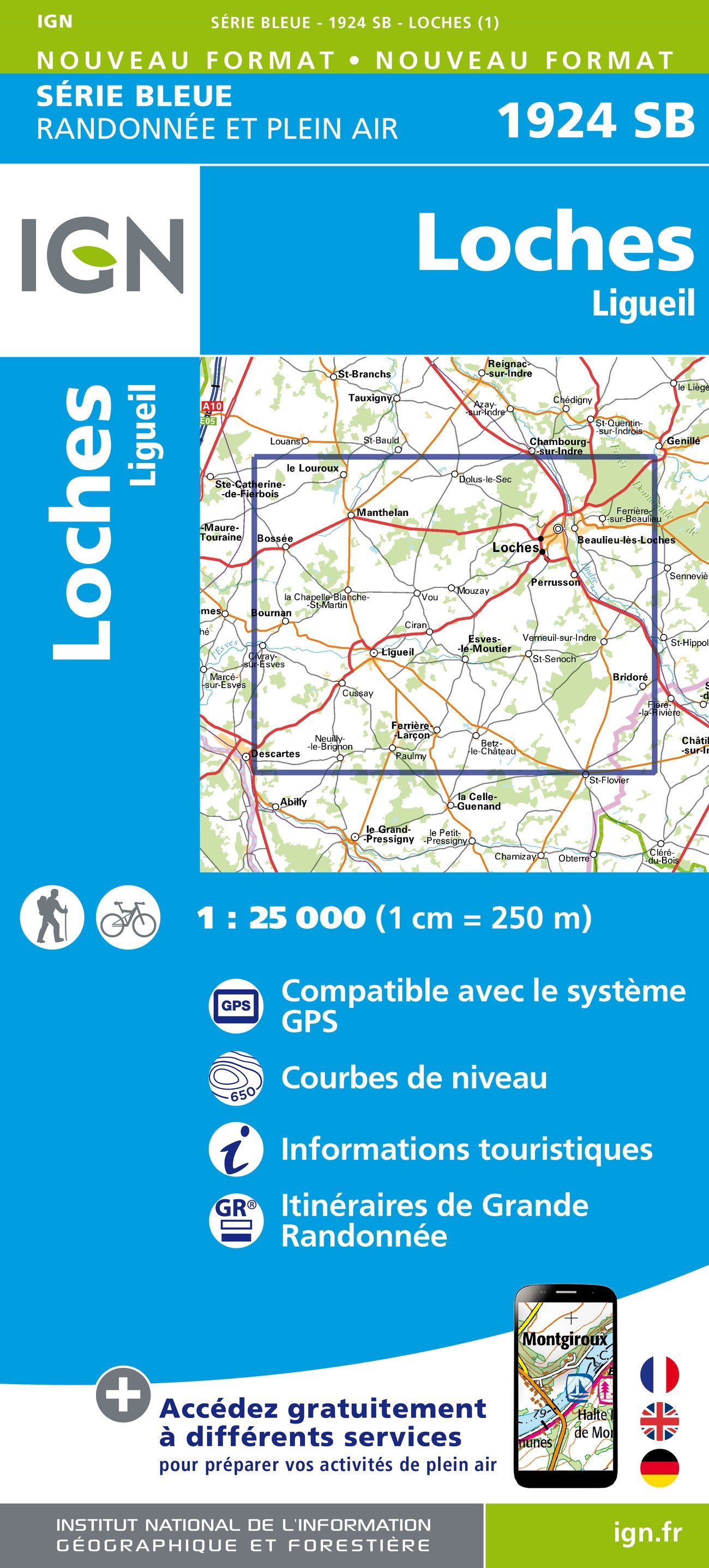
Wandelkaart 1924 SB Loches & Ligueil - IGN
Loches & Ligueil zijn gelegen in de Indre-et-Loire
Korte omschrijving
Wandelkaarten Centre Val de Loire, Frankrijk van Institut Géographique National. Ideaal voor tochten in Frankrijk.
Wandelkaart 1924 SB - Loches & Ligueil Productomschrijving: Deze topografische kaarten hebben een zeer nauwkeurige gronddetail, niet te vergeten de topografische hoogteprofielen, die het wa...

Specificaties
- Uitgever: Institut Géographique National
- ISBN-13: 9782758534051
- HOOFDCATEGORIEËN: Wandelkaart
- Activiteiten: Wandelen, Hiking & Trekking
- Regio: Centre Val de Loire, Frankrijk
- Land: Frankrijk
- Departement: Indre-et-Loire (37)
- Schaal: 1:25000
- Editie: 1
- Taal: Frans
- Reeks/Serie: IGN France > TOP25 Randoo / Série Bleue
- De Franse Regio's: Centre-val-de-Loire
Volledige omschrijving
Wandelkaart 1924 SB - Loches & Ligueil
Productomschrijving: Deze topografische kaarten hebben een zeer nauwkeurige gronddetail, niet te vergeten de topografische hoogteprofielen, die het wandelen een stuk gemakkelijker maken. Loches is een historisch Frans stadje, gelegen aan de rivier Indre in het departement Indre-et-Loire, met ca. 7000 inwoners (Lochois genaamd). De stad draagt de zichtbare sporen van haar militair verleden, en heeft in het historische centrum haar middeleeuwse karakter weten te bewaren. Van dit vrij goed bewaarde stadsdeel zijn nog twee van de drie oorspronkelijke stadsomwallingen te zien.
Desciptive produits: Ces cartes topographiques d'une très grande précision contiennent tous les détails existant sur le terrain: voies de communication jusqu'au moindre sentier, constructions jusqu'au hangar, bois, arbre isolé, rivière, source... Sans oublier la représentation du relief par des courbes de niveau.
Locatie op kaart
Overzichtskaarten
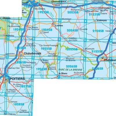
IGN TOP25 Wandelkaarten Loire Centre - Zuidelijk DEEL - Bourges - Poitiers
IGN TOP25 Wandelkaarten Loire Centre - Zuidelijk DEEL - Bourges - Poitiers
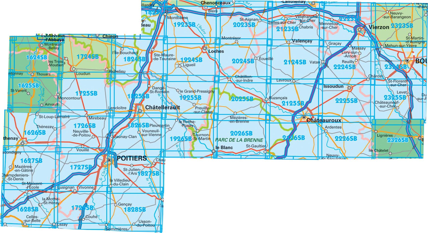
Producten op de overzichtskaart
Klik op een product om naar de detailpagina te gaan.
- Wandelkaart 1627 SB Mazières-en-Gâtine & Vasles - IGN
- Wandelkaart 1724 SB Loudun & Richelieu - IGN
- Wandelkaart 1725 SB Lencloître & St-Jean-de-Sauves - IGN
- Wandelkaart 1727 SB Poitiers & Coulombiers - IGN
- Wandelkaart 1728 SB Vivonne & Lusignan - IGN
- Wandelkaart 1824 SB Ste-Maure-de-Touraine & L'Ile-Bouchard IGN
- Wandelkaart 1825 SB Châtellerault & Descartes - IGN
- Wandelkaart 1827 SB Poitiers & Chauvigny - IGN
- Wandelkaart 1923 SB Bléré- Chenonceaux & Veigné - IGN
- Wandelkaart 1924 SB Loches & Ligueil - IGN
- Wandelkaart 1925 SB Preuilly-sur-Claise & le Grand-Pressigny
- Wandelkaart 1926 SB Le Blanc- Pleumartin & La Roche-Posay - IGN
- Wandelkaart 2024 SB Châtillon-sur-Indre - Ecueillé - IGN
- Wandelkaart 2025 SB Buzançais & Mézières-en-Brenne - IGN
- Wandelkaart 2026 SB Saint-Gaultier & Rosney - IGN
- Wandelkaart 2123 SB Selles-sur-Cher & Chabris - IGN
- Wandelkaart 2124 SB Luçay-le-Mâle & Poulaines - IGN
- Wandelkaart 2125 SB Châteauroux & Levroux - IGN
- Wandelkaart 2126 SB Le Poinçonnet- Velles & Luant - IGN
- Wandelkaart 2223 SB Vierzon & Mennetou-sur-Cher - IGN
- Wandelkaart 2224 SB Vatan & Chârost - IGN
- Wandelkaart 2225 SB Issoudun & Neuvy-Paillouxt - IGN
- Wandelkaart 2226 SB Ardentes & La Berthenoux - IGN
- Wandelkaart 2323 SB St-Martin-D'Auxigny & Foëcy - IGN
- Wandelkaart 2324 SB Bourges & Mehun-sur-Yèvre - IGN
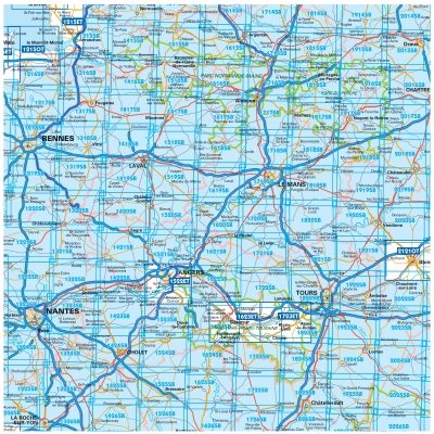
TOP25 et Série Blue ZONE B2
TOP25 et Série Blue ZONE B2
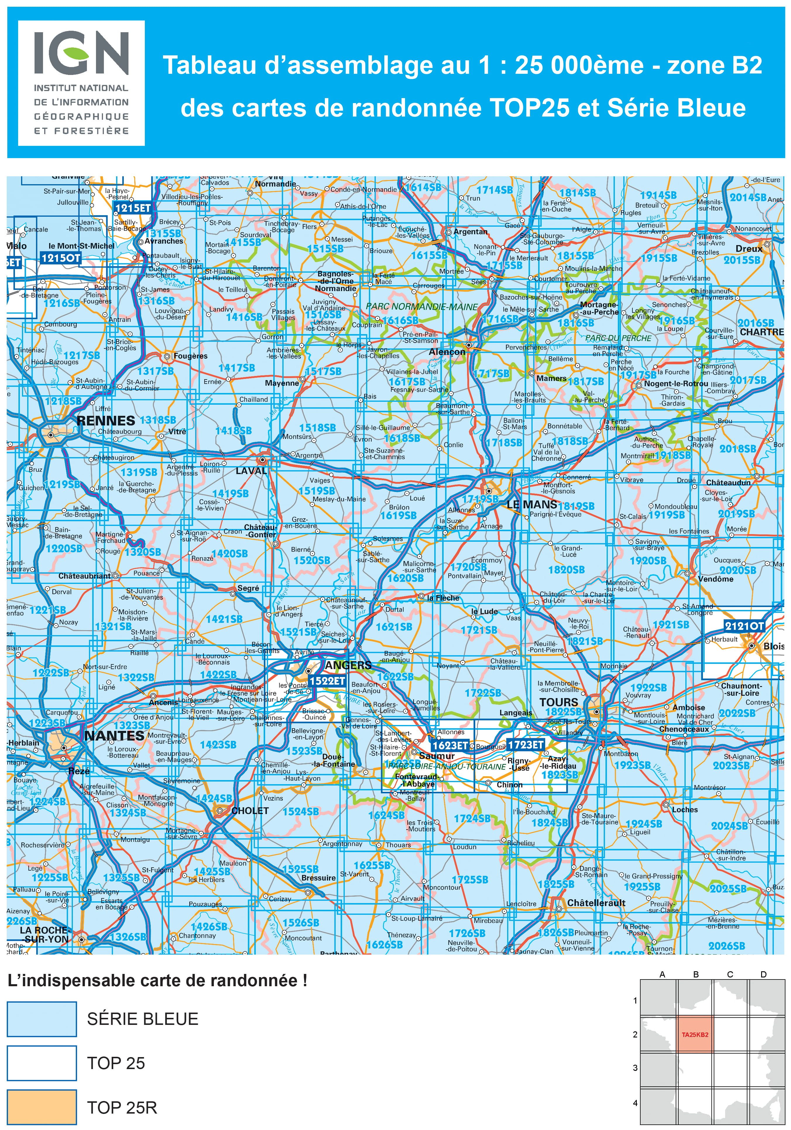
Producten op de overzichtskaart
Klik op een product om naar de detailpagina te gaan.
- Wandelkaart 1215 OT Le Mont-St-Michel & Dol-de-Bretagne - IGN
- Wandelkaart 1216 SB Pontorson & Dol-de-Bretagne - IGN
- Wandelkaart 1217 SB Combourg & St-Aubin-d'Augigné Bretagne - IGN
- Wandelkaart 1218 SB Rennes- Cesson-Sévigné & Liffré - IGN
- Wandelkaart 1219 SB Bruz & Janzé - IGN
- Wandelkaart 1221 SB Guémené & Penfao - IGN
- Wandelkaart 1222 SB Blain & Nort-sur-Erdre - IGN
- Wandelkaart 1223 SB Nantes & St-Herblain - IGN
- Wandelkaart 1223 SB Nantes - St-Herblain - IGN
- Wandelkaart 1224 SB St-Philbert-de-Grand-Lieu - IGN
- Wandelkaart 1225 SB Le Poiré-sur-Vie & Legé - IGN
- Wandelkaart 1226 SB Le Poiré-sur-Vie- Aizenay & Les Achards
- Wandelkaart 1315 SB Ducy-Brécey & Avranches - IGN
- Wandelkaart 1316 ET Milly-la-Forêt, Malesherbes & La Ferté-Alais
- Wandelkaart 1316 SB St-Hilaire-du-Harcouët - St-James - IGN
- Wandelkaart 1317 SB Fougères & St-Brice-en-Coglès - IGN
- Wandelkaart 1318 SB Vitré & Châteaubourg - IGN
- Wandelkaart 1319 SB La Guerche-de-Bretagne - IGN
- Wandelkaart 1320 SB Châteaubriant & Pouancé - IGN
- Wandelkaart 1321 SB St-Mars-la-Jaille - IGN
- Wandelkaart 1322 SB Ancenis & Riaillé - Frankrijk - IGN
- Wandelkaart 1323 SB Vallet & Gesté - IGN
- Wandelkaart 1324 SB Clisson & La Bruffière - IGN
- Wandelkaart 1325 SB Les Essarts & St-Fulgent - IGN
- Wandelkaart 1326 SB La Roche-sur-Yon & Bounezeau - IGN
- Wandelkaart 1415 SB Tinchebray-Bocage & Sourdeval - IGN
- Wandelkaart 1416 SB Le Teilleul & Landivy - IGN
- Wandelkaart 1417 SB Ernée & Gorron - IGN
- Wandelkaart 1418 SB Laval & Port Brillet - IGN
- Wandelkaart 1419 SB Cossé-le-Vivien & L'Huisserie - IGN
- Wandelkaart 1420 SB Craon & Chemazé - IGN
- Wandelkaart 1421 SB Segré & Candé - IGN
- Wandelkaart 1422 SB Chalonnes-sur-Loire - IGN
- Wandelkaart 1423 SB Chemillé & Beaupréau - IGN
- Wandelkaart 1424 SB Cholet & Mortagne-sur-Sèvre - IGN
- Wandelkaart 1425 SB Les Herbiers & Mauléon - IGN
- Wandelkaart 1426 SB Chantonnay - IGN
- Wandelkaart 1515 SB Flers & Briouze - IGN
- Wandelkaart 1516 SB Domfront & Lassay-les-Châteaux - IGN
- Wandelkaart 1517 SB Mayenne & Le Horps - IGN
- Wandelkaart 1518 SB Evron & Montsûrs - IGN
- Wandelkaart 1519 SB Meslay-du-Maine & Vaiges - IGN
- Wandelkaart 1520 SB Château-Gontier & Grez-en-Bouère - IGN
- Wandelkaart 1521 SB Le Lion-d'Angers - IGN
- Wandelkaart 1522 ET Angers - IGN
- Wandelkaart 1522 ET Angers France - IGN
- Wandelkaart 1523 SB Thouarcé & Valanjou - IGN
- Wandelkaart 1524 SB Vihiers & Yzernay - IGN
- Wandelkaart 1525 SB Bressuire & Cerizay - IGN
- Wandelkaart 1526 SB Moncoutant & La Chapelle-St-Laurent - IGN
- Wandelkaart 1614 SB Falaise & Morteaux-Couliboeuf - IGN
- Wandelkaart 1615 SB Argentan- Putanges & Pont-Ecrepin - IGN
- Wandelkaart 1616 SB La Ferté-Macé & Pré-en-Pail - IGN
- Wandelkaart 1617 SB Villaines-la-Juhel & St-Pierre-des-Nids - IGN
- Wandelkaart 1618 SB Sillé-le-Guillaume & Conlie Ste-Suzanne
- Wandelkaart 1619 SB Loué- Brûlon & Noyen-sur-Sarthe - IGN
- Wandelkaart 1620 SB La Flèche & Sablé-sur-Sarthe - IGN
- Wandelkaart 1622 SB Longué - Jumelles & Beaufort - IGN
- Wandelkaart 1623 ET Saumur- Bourgueil & Fontevraud-l'Abbaye
- Wandelkaart 1623 SB Saumur & Doué-la-Fontaine - IGN
- Wandelkaart 1624 SB Thouars & Le Puy-Notre-Dame - IGN
- Wandelkaart 1625 SB Thouars & Airvault - IGN
- Wandelkaart 1626 SB Parthenay & Thénezay - IGN
- Wandelkaart 1714 SB Vimoutiers & Trun - IGN
- Wandelkaart 1715 SB Sées & Gace - Bass-Normandie - IGN
- Wandelkaart 1716 SB Alençon & Sées - IGN
- Wandelkaart 1717 SB Alençon & Marolles-les-Braults - IGN
- Wandelkaart 1719 SB Le Mans & La Suze-sur-Sarthe - IGN
- Wandelkaart 1720 SB Ecommoy & Cérans-Fouilletourte - IGN
- Wandelkaart 1721 SB Le Lude & Château-la-Vallière - IGN
- Wandelkaart 1722 SB Noyant & Savigné-sur-Lathan - IGN
- Wandelkaart 1723 ET Chinon- Langeais & Azay-le-Rideau - IGN
- Wandelkaart 1724 SB Loudun & Richelieu - IGN
- Wandelkaart 1725 SB Lencloître & St-Jean-de-Sauves - IGN
- Wandelkaart 1726 SB Neuville-de-Poitou, Vouillé & Mirebeau - IGN
- Wandelkaart 1814 SB Rugles & La Ferté-Frênel - IGN
- Wandelkaart 1815 SB L'Aigle- Ste-Gauburge & Ste Colombe - IGN
- Wandelkaart 1816 SB Mortagne-au-Perche & Mêle-sur-Sarthe - IGN
- Wandelkaart 1817 SB Mamers - Bellême & Le Theil - IGN
- Wandelkaart 1818 SB La Ferté-Bernard & Bonnétable - IGN
- Wandelkaart 1819 SB Bouloire & Le Grand-Lucé - IGN
- Wandelkaart 1820 SB Château-du-Loir & La Chartre-sur-Loir- IGN
- Wandelkaart 1821 SB Château-du-Loir & Neuillé-Pont-Pierre- IGN
- Wandelkaart 1822 SB Tours & Langeais - IGN
- Wandelkaart 1823 SB Chambray-les-Tours & Langeais - IGN
- Wandelkaart 1824 SB Ste-Maure-de-Touraine & L'Ile-Bouchard IGN
- Wandelkaart 1825 SB Châtellerault & Descartes - IGN
- Wandelkaart 1825 SB Châtellerault & Descartes - IGN
- Wandelkaart 1914 SB Breteuil & La Neuve-Lyre - IGN
- Wandelkaart 1915 SB Verneuil-sur-Avre & Bourth - IGN
- Wandelkaart 1916 SB La Loupe & Rémalard-en-Perche - IGN
- Wandelkaart 1917 SB Nogent-le-Rotrou & Thiron-Gardais - IGN
- Wandelkaart 1918 SB Authon-du-Perche & La Bazoche-Gouët - IGN
- Wandelkaart 1919 SB St-Calais & Droué - IGN
- Wandelkaart 1920 SB Vendôme & Montoire-sur-le-Loir - IGN
- Wandelkaart 1921 SB Château-Renault & St-Amand-Longpré - IGN
- Wandelkaart 1922 SB Amboise & Montlouis-sur-Loire - IGN
- Wandelkaart 1923 SB Bléré- Chenonceaux & Veigné - IGN
- Wandelkaart 1924 SB Loches & Ligueil - IGN
- Wandelkaart 1925 SB Preuilly-sur-Claise & le Grand-Pressigny
- Wandelkaart 2014 SB St-André-de-l'Eure & Nonancourt - IGN
- Wandelkaart 2015 SB Dreux & Nonancourt - IGN
- Wandelkaart 2016 SB Chartres & Courville-sur Eure - IGN
- Wandelkaart 2017 SB Illiers-Combray & Bailleau-le-Pin - IGN
- Wandelkaart 2018 SB Châteaudun & Brou - IGN
- Wandelkaart 2019 SB Cloyes-sur-le-Loir - IGN
- Wandelkaart 2020 SB Selommes & St-Ouen - IGN
- Wandelkaart 2022 SB Montrichard & Contres - IGN
- Wandelkaart 2121 OT Blois- Chambord & Cheverny - IGN
- Wandelkaart 2121 OT Blois- Chambord & Cheverny - IGN
- Wandelkaart 2023 SB Montrichard & St-Aignan - IGN
- Wandelkaart 2024 SB Châtillon-sur-Indre - Ecueillé - IGN
- Wandelkaart 2025 SB Buzançais & Mézières-en-Brenne - IGN
- Wandelkaart 2026 SB Saint-Gaultier & Rosney - IGN
Artikelen uit dezelfde regio
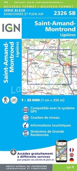
Wandelkaart 2326 SB St-Amand-Montrond & Lignières - IGN • 9782758537199
Wandelkaart 2326 SB - St-Amand-Montrond & Lignières Productomschrijving: St-Amand-Montrond & Lignières zijn gemeentes in het zuiden van het departement Cher in de regio Centre. ze zijn gelegen langs de A71 en de Cher in het geografische centrum van Frankrijk. Ze is tevens hoofdstad van de Boischaut. Tussen 2014 en 2018, worden alle SERIE BLUE kaarten in de collectie vernieuwd. Een nieuwe k…

Wandelkaart 2323 SB St-Martin-D'Auxigny & Foëcy - IGN • 9782758534181
Wandelkaart 2323 SB - St-Martin-D'Auxigny & Foëcy Productomschrijving: Deze topografische kaarten hebben een zeer nauwkeurige gronddetail, niet te vergeten de topografische hoogteprofielen, die het wandelen een stuk gemakkelijker maken. Saint-Martin-d'Auxigny is een gemeente in het Franse departement Cher (regio Centre). De plaats maakt deel uit van het arrondissement Bourges. Descipt…
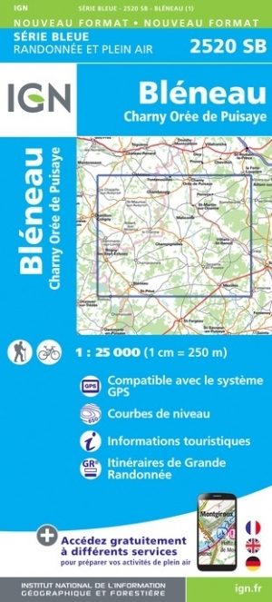
Wandelkaart 2520 SB Bléneau & Champignelles - IGN • 9782758548683
Wandelkaart - Bléneau & Champignelles Productomschrijving: Bléneau & Champignelles zijn gemeentes in het Franse departement Yonne in de regio Bourgogne-Franche-Comté. De plaats maakt deel uit van het arrondissement Auxerre. Tussen 2014 en 2018 vernieuwt IGN haar volledige collectie serie blauw. Een nieuwe toewijzing voor optimale leesbaarheid, met een grotere mate van geometrische nauw…

Wandelkaart 2220 SB Olivet- La Ferté-St-Aubin & Jargeau - IGN • 9782758548461
Wandelkaart 2220 SB - Olivet- La Ferté-St-Aubin & Jargeau Productomschrijving: Olivet- La Ferté-St-Aubin & Jargeau zijn gemeentes in het Franse departement Loiret in de regio Centre-Val de Loire. De plaats maakt deel uit van het arrondissement Orléans. Tussen 2014 en 2020 vernieuwt IGN haar volledige collectie serie blauw. Een nieuwe toewijzing voor optimale leesbaarheid, met een grote…
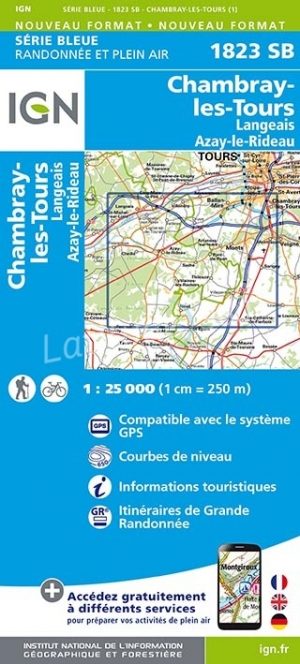
Wandelkaart 1823 SB Chambray-les-Tours & Langeais - IGN • 9782758537083
Wandelkaart 1823 SB - Chambray-les-Tours & Langeais Productbeschrijving: Chambray-lès-Tours, Langeais & Azay-le-Rideau zijn gemeentes in het Franse departement Indre-et-Loire, regio Centre. De plaats maakt deel uit van het arrondissement Tours. Dicht bij de rivier de Loire, ligt deze plaats in een kom. Tours op zich is een mooie tipisch Franse omgeving, met de nadruk op de Loire als trekpl…