

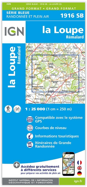
Wandelkaart 1916 SB La Loupe & Rémalard-en-Perche - IGN
Nogent-le-Rotrou - Moutiers-au-Parc naturel régional du Perche

Korte omschrijving
Wandelkaarten Centre Val de Loire, Frankrijk van Institut Géographique National. Ideaal voor tochten in Frankrijk.
Wandelkaart La Loupe & Rémalard-en-Perche - IGN Productomschrijving: La Loupe & Rémalard-en-Perche zijn gemeentes in het Franse departement Eure-et-Loir in de regio Centre-Val de Loire. De p...

Specificaties
- Uitgever: Institut Géographique National
- ISBN-13: 9782758554592
- HOOFDCATEGORIEËN: Wandelkaart
- Activiteiten: Wandelen, Hiking & Trekking
- Regio: Centre Val de Loire, Frankrijk
- Land: Frankrijk
- Departement: Eure-et-Loir (28)
- Regionale parken: Parc naturel régional du Perche
- Schaal: 1:25000
- Editie: 2
- Taal: Frans
- Reeks/Serie: IGN France > TOP25 Randoo / Série Bleue
- De Franse Regio's: Centre-val-de-Loire
Volledige omschrijving
Wandelkaart La Loupe & Rémalard-en-Perche - IGN
Productomschrijving: La Loupe & Rémalard-en-Perche zijn gemeentes in het Franse departement Eure-et-Loir in de regio Centre-Val de Loire. De plaats maakt deel uit van het arrondissement Nogent-le-Rotrou.
Omvat: La Loupe, Rémalard,La Framboisière, Moutiers-au-Parc naturel régional du Perche, L'Hôme-Chamondot, La Ferté-Vidame, Bretoncelles, Les Ressuintes, Montireau, Rémalard en Parc naturel régional du Perche, La Loupe, La Madeleine-Bouvet, Saint-Éliph, Saint-Germain-des-Grois, Senonches, Friaize, Saint-Victor-de-Buthon.
Te ontdekken: Parc naturel régional du Perche,Forêt de Longny, Forêt de Champrond, Forêt Domaniale de Montécot, Forêt Domaniale de Senonches, Forêt de la Ferté-Vidame,Dolmen de la Grosse Pierre, Notre-Dame de Pitié, Espace St-Simon, Château de Voré, Manoir de Boiscorde, Arboretum de Boiscorde.
Afmeting: 96 cm x 121 cm
• De klant vindt makkelijk de kaart terug die hij nodig heeft op de overzichtkaart met de nieuwe decoupages.
• Aandacht voor HIKING en OUTDOOR positionering
• De + producten die de rijke inhoud van deze nieuwe serie beschrijven
• Gratis toegang tot mobiele internetdiensten
• De legende in 3 talen, ideaal voor buitenlandse toeristen
- De gebruiker heeft de mogelijkheid om de IGN-cartografie op zijn smartphone te raadplegen
- Ga naar het lokale weer op de mobiele site van METEO FRANCE
- Beheer uw kaartenbibliotheek om op de hoogte te blijven van nieuwe edities

Locatie op kaart
Overzichtskaarten
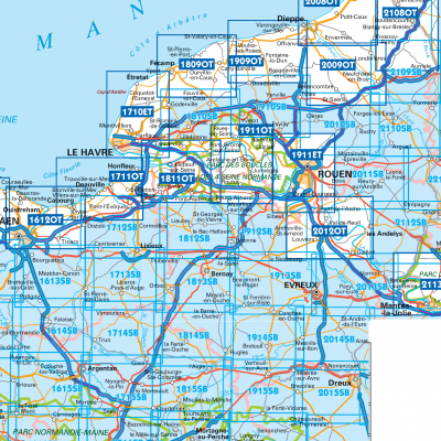
IGN TOP25 Wandelkaarten Normandië Oost
IGN TOP25 Wandelkaarten Normandië Oost

Producten op de overzichtskaart
Klik op een product om naar de detailpagina te gaan.
- Wandelkaart 1615 SB Argentan- Putanges & Pont-Ecrepin - IGN
- Wandelkaart 1710 ET Le Havre & Etretat - IGN
- Wandelkaart 1711 OT Honfleur- Deauville & Cabourg - IGN
- Wandelkaart 1712 SB Lisieux & Cambremer - IGN
- Wandelkaart 1714 SB Vimoutiers & Trun - IGN
- Wandelkaart 1715 SB Sées & Gace - Bass-Normandie - IGN
- Wandelkaart 1716 SB Alençon & Sées - IGN
- Wandelkaart 1717 SB Alençon & Marolles-les-Braults - IGN
- Wandelkaart 1810 SB Bolbec & Lillebonne - IGN
- Wandelkaart 1811 OT Pont-Audemer-Tancarville - IGN
- Wandelkaart 1812 SB Brionne - Cormeilles - IGN
- Wandelkaart 1816 SB Mortagne-au-Perche & Mêle-sur-Sarthe - IGN
- Wandelkaart 1817 SB Mamers - Bellême & Le Theil - IGN
- Wandelkaart 1913 SB Bernay & Orbec- Haut-Normandie - IGN
- Wandelkaart 1914 SB Breteuil & La Neuve-Lyre - IGN
- Wandelkaart 1909 OT St-Valery-en-Caux - Veules-les-Roses - IGN
- Wandelkaart 1911 OT Forêts Brotonne et du Trait-Maulévrier - IGN
- Wandelkaart 1916 SB La Loupe & Rémalard-en-Perche - IGN
- Wandelkaart 2107 OT St-Valery-sur-Somme & Baie de Somme - IGN
- Wandelkaart 2008 OT Dieppe- Eu & Forêt d'Arques - IGN
- Wandelkaart 2009 OT Forêt d'Eawy & Neufchâtel-en-Bray - IGN
- Wandelkaart 2010 SB St-Saëns & Clères - Haut France - IGN
- Wandelkaart 2011 SB Fleury-sur-Andelle & Lyons-la-Forêt - IGN
- Wandelkaart 2112 SB Gisors & Etrépagny - IGN
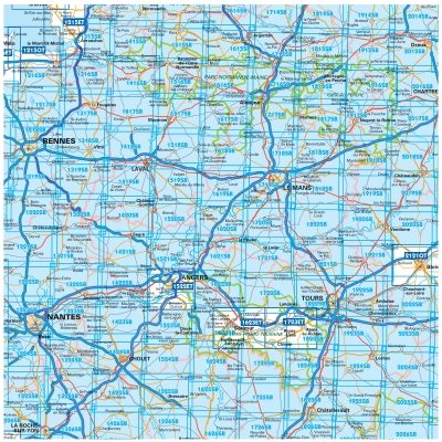
TOP25 et Série Blue ZONE B2
TOP25 et Série Blue ZONE B2
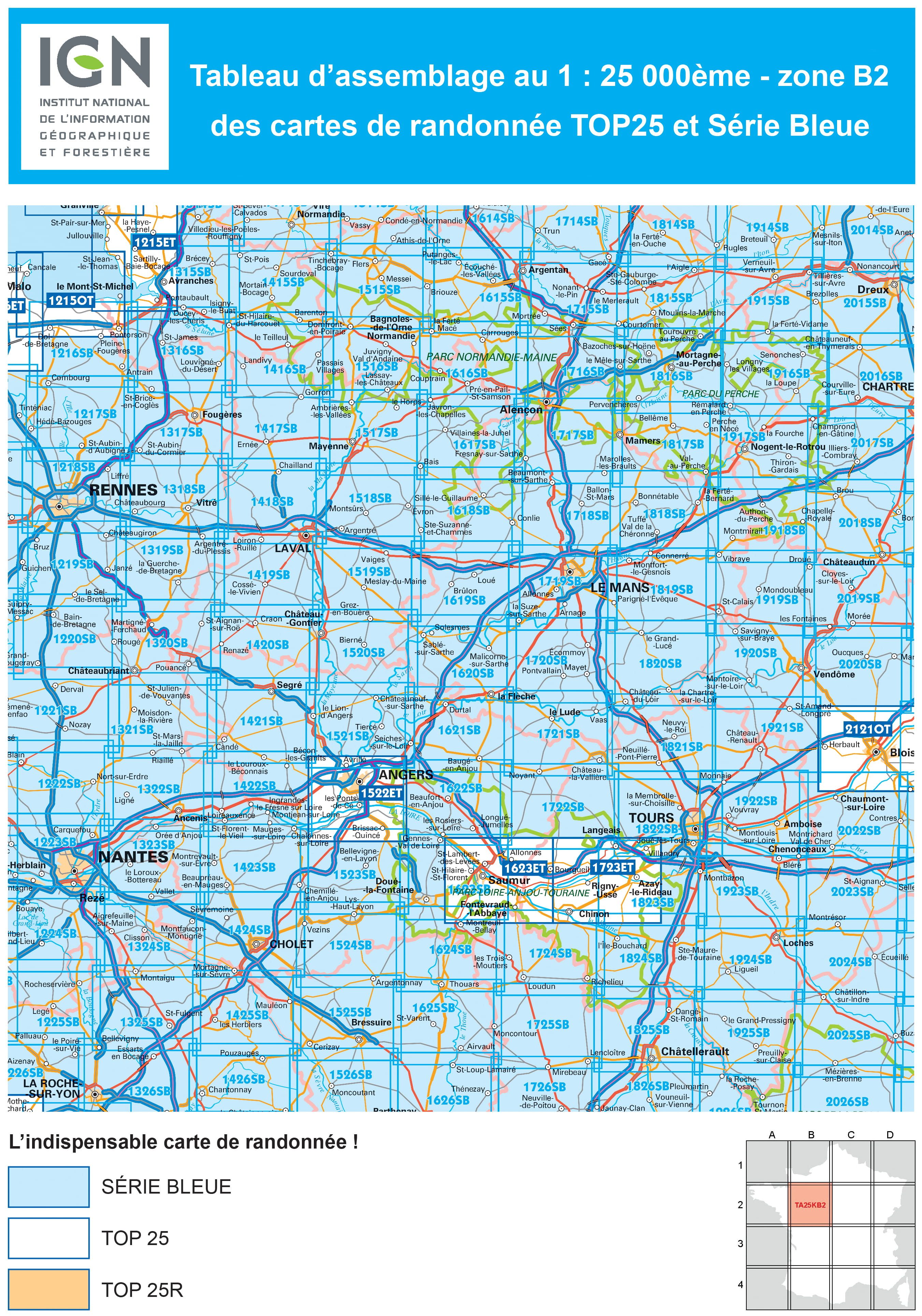
Producten op de overzichtskaart
Klik op een product om naar de detailpagina te gaan.
- Wandelkaart 1215 OT Le Mont-St-Michel & Dol-de-Bretagne - IGN
- Wandelkaart 1216 SB Pontorson & Dol-de-Bretagne - IGN
- Wandelkaart 1217 SB Combourg & St-Aubin-d'Augigné Bretagne - IGN
- Wandelkaart 1218 SB Rennes- Cesson-Sévigné & Liffré - IGN
- Wandelkaart 1219 SB Bruz & Janzé - IGN
- Wandelkaart 1221 SB Guémené & Penfao - IGN
- Wandelkaart 1222 SB Blain & Nort-sur-Erdre - IGN
- Wandelkaart 1223 SB Nantes & St-Herblain - IGN
- Wandelkaart 1223 SB Nantes - St-Herblain - IGN
- Wandelkaart 1224 SB St-Philbert-de-Grand-Lieu - IGN
- Wandelkaart 1225 SB Le Poiré-sur-Vie & Legé - IGN
- Wandelkaart 1226 SB Le Poiré-sur-Vie- Aizenay & Les Achards
- Wandelkaart 1315 SB Ducy-Brécey & Avranches - IGN
- Wandelkaart 1316 ET Milly-la-Forêt, Malesherbes & La Ferté-Alais
- Wandelkaart 1316 SB St-Hilaire-du-Harcouët - St-James - IGN
- Wandelkaart 1317 SB Fougères & St-Brice-en-Coglès - IGN
- Wandelkaart 1318 SB Vitré & Châteaubourg - IGN
- Wandelkaart 1319 SB La Guerche-de-Bretagne - IGN
- Wandelkaart 1320 SB Châteaubriant & Pouancé - IGN
- Wandelkaart 1321 SB St-Mars-la-Jaille - IGN
- Wandelkaart 1322 SB Ancenis & Riaillé - Frankrijk - IGN
- Wandelkaart 1323 SB Vallet & Gesté - IGN
- Wandelkaart 1324 SB Clisson & La Bruffière - IGN
- Wandelkaart 1325 SB Les Essarts & St-Fulgent - IGN
- Wandelkaart 1326 SB La Roche-sur-Yon & Bounezeau - IGN
- Wandelkaart 1415 SB Tinchebray-Bocage & Sourdeval - IGN
- Wandelkaart 1416 SB Le Teilleul & Landivy - IGN
- Wandelkaart 1417 SB Ernée & Gorron - IGN
- Wandelkaart 1418 SB Laval & Port Brillet - IGN
- Wandelkaart 1419 SB Cossé-le-Vivien & L'Huisserie - IGN
- Wandelkaart 1420 SB Craon & Chemazé - IGN
- Wandelkaart 1421 SB Segré & Candé - IGN
- Wandelkaart 1422 SB Chalonnes-sur-Loire - IGN
- Wandelkaart 1423 SB Chemillé & Beaupréau - IGN
- Wandelkaart 1424 SB Cholet & Mortagne-sur-Sèvre - IGN
- Wandelkaart 1425 SB Les Herbiers & Mauléon - IGN
- Wandelkaart 1426 SB Chantonnay - IGN
- Wandelkaart 1515 SB Flers & Briouze - IGN
- Wandelkaart 1516 SB Domfront & Lassay-les-Châteaux - IGN
- Wandelkaart 1517 SB Mayenne & Le Horps - IGN
- Wandelkaart 1518 SB Evron & Montsûrs - IGN
- Wandelkaart 1519 SB Meslay-du-Maine & Vaiges - IGN
- Wandelkaart 1520 SB Château-Gontier & Grez-en-Bouère - IGN
- Wandelkaart 1521 SB Le Lion-d'Angers - IGN
- Wandelkaart 1522 ET Angers - IGN
- Wandelkaart 1522 ET Angers France - IGN
- Wandelkaart 1523 SB Thouarcé & Valanjou - IGN
- Wandelkaart 1524 SB Vihiers & Yzernay - IGN
- Wandelkaart 1525 SB Bressuire & Cerizay - IGN
- Wandelkaart 1526 SB Moncoutant & La Chapelle-St-Laurent - IGN
- Wandelkaart 1614 SB Falaise & Morteaux-Couliboeuf - IGN
- Wandelkaart 1615 SB Argentan- Putanges & Pont-Ecrepin - IGN
- Wandelkaart 1616 SB La Ferté-Macé & Pré-en-Pail - IGN
- Wandelkaart 1617 SB Villaines-la-Juhel & St-Pierre-des-Nids - IGN
- Wandelkaart 1618 SB Sillé-le-Guillaume & Conlie Ste-Suzanne
- Wandelkaart 1619 SB Loué- Brûlon & Noyen-sur-Sarthe - IGN
- Wandelkaart 1620 SB La Flèche & Sablé-sur-Sarthe - IGN
- Wandelkaart 1622 SB Longué - Jumelles & Beaufort - IGN
- Wandelkaart 1623 ET Saumur- Bourgueil & Fontevraud-l'Abbaye
- Wandelkaart 1623 SB Saumur & Doué-la-Fontaine - IGN
- Wandelkaart 1624 SB Thouars & Le Puy-Notre-Dame - IGN
- Wandelkaart 1625 SB Thouars & Airvault - IGN
- Wandelkaart 1626 SB Parthenay & Thénezay - IGN
- Wandelkaart 1714 SB Vimoutiers & Trun - IGN
- Wandelkaart 1715 SB Sées & Gace - Bass-Normandie - IGN
- Wandelkaart 1716 SB Alençon & Sées - IGN
- Wandelkaart 1717 SB Alençon & Marolles-les-Braults - IGN
- Wandelkaart 1719 SB Le Mans & La Suze-sur-Sarthe - IGN
- Wandelkaart 1720 SB Ecommoy & Cérans-Fouilletourte - IGN
- Wandelkaart 1721 SB Le Lude & Château-la-Vallière - IGN
- Wandelkaart 1722 SB Noyant & Savigné-sur-Lathan - IGN
- Wandelkaart 1723 ET Chinon- Langeais & Azay-le-Rideau - IGN
- Wandelkaart 1724 SB Loudun & Richelieu - IGN
- Wandelkaart 1725 SB Lencloître & St-Jean-de-Sauves - IGN
- Wandelkaart 1726 SB Neuville-de-Poitou, Vouillé & Mirebeau - IGN
- Wandelkaart 1814 SB Rugles & La Ferté-Frênel - IGN
- Wandelkaart 1815 SB L'Aigle- Ste-Gauburge & Ste Colombe - IGN
- Wandelkaart 1816 SB Mortagne-au-Perche & Mêle-sur-Sarthe - IGN
- Wandelkaart 1817 SB Mamers - Bellême & Le Theil - IGN
- Wandelkaart 1818 SB La Ferté-Bernard & Bonnétable - IGN
- Wandelkaart 1819 SB Bouloire & Le Grand-Lucé - IGN
- Wandelkaart 1820 SB Château-du-Loir & La Chartre-sur-Loir- IGN
- Wandelkaart 1821 SB Château-du-Loir & Neuillé-Pont-Pierre- IGN
- Wandelkaart 1822 SB Tours & Langeais - IGN
- Wandelkaart 1823 SB Chambray-les-Tours & Langeais - IGN
- Wandelkaart 1824 SB Ste-Maure-de-Touraine & L'Ile-Bouchard IGN
- Wandelkaart 1825 SB Châtellerault & Descartes - IGN
- Wandelkaart 1825 SB Châtellerault & Descartes - IGN
- Wandelkaart 1914 SB Breteuil & La Neuve-Lyre - IGN
- Wandelkaart 1915 SB Verneuil-sur-Avre & Bourth - IGN
- Wandelkaart 1916 SB La Loupe & Rémalard-en-Perche - IGN
- Wandelkaart 1917 SB Nogent-le-Rotrou & Thiron-Gardais - IGN
- Wandelkaart 1918 SB Authon-du-Perche & La Bazoche-Gouët - IGN
- Wandelkaart 1919 SB St-Calais & Droué - IGN
- Wandelkaart 1920 SB Vendôme & Montoire-sur-le-Loir - IGN
- Wandelkaart 1921 SB Château-Renault & St-Amand-Longpré - IGN
- Wandelkaart 1922 SB Amboise & Montlouis-sur-Loire - IGN
- Wandelkaart 1923 SB Bléré- Chenonceaux & Veigné - IGN
- Wandelkaart 1924 SB Loches & Ligueil - IGN
- Wandelkaart 1925 SB Preuilly-sur-Claise & le Grand-Pressigny
- Wandelkaart 2014 SB St-André-de-l'Eure & Nonancourt - IGN
- Wandelkaart 2015 SB Dreux & Nonancourt - IGN
- Wandelkaart 2016 SB Chartres & Courville-sur Eure - IGN
- Wandelkaart 2017 SB Illiers-Combray & Bailleau-le-Pin - IGN
- Wandelkaart 2018 SB Châteaudun & Brou - IGN
- Wandelkaart 2019 SB Cloyes-sur-le-Loir - IGN
- Wandelkaart 2020 SB Selommes & St-Ouen - IGN
- Wandelkaart 2022 SB Montrichard & Contres - IGN
- Wandelkaart 2121 OT Blois- Chambord & Cheverny - IGN
- Wandelkaart 2121 OT Blois- Chambord & Cheverny - IGN
- Wandelkaart 2023 SB Montrichard & St-Aignan - IGN
- Wandelkaart 2024 SB Châtillon-sur-Indre - Ecueillé - IGN
- Wandelkaart 2025 SB Buzançais & Mézières-en-Brenne - IGN
- Wandelkaart 2026 SB Saint-Gaultier & Rosney - IGN
Artikelen uit dezelfde regio
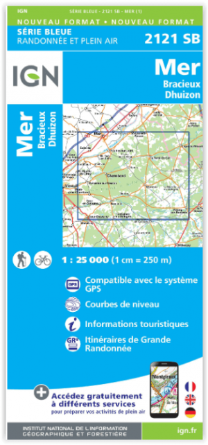
Wandelkaart 2121 SB Mer - Bracieux - Dhuizon - IGN • 9782758539193
Wandelkaart Mer - Bracieux - Dhuizon - IGN Productomschrijving: Bracieux & Dhuizon zijn gemeentes in het Franse departement Loir-et-Cher, in de regio Centre-Val de Loire. De plaats maakt deel uit van het arrondissement Blois en liggen tussen de wereldberoemde kastelen van Chambord en Cheverny. De TOP 25 kaarten (kaart nummers die eindigen op SB) zicht de nieuwe reeks van IGN, en bestaa…
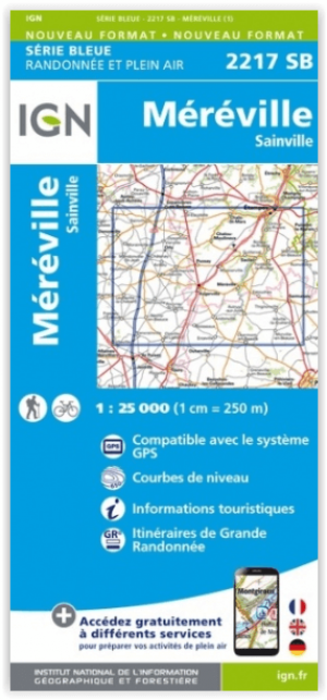
Wandelkaart 2217 SB Etampes- Méréville & Sainville - IGN • 9782758548447
Wandelkaart 2217 SB - Etampes- Méréville & Sainville Productomschrijving: Etampes- Méréville & Sainville zijn gemeentes in het Franse departement Essonne in de regio Île-de-France. De plaats maakt deel uit van het arrondissement Étampes. Desciptive produits: Une nouvelle cartographie pour une lisibilité optimale, avec une meilleure précision géométrique et des informations touristique…

Fietsgids St-Jacobs fietsroute DEEL 2 Tours > Pyreneeën - Pirola • 9789083518220
Fietsgids St-Jacobs fietsroute DEEL 2 - Pirola Productomschrijving: Santiago de Compostela had een magische klank in de oren van onze voorouders. Pelgrims uit heel Europa trokken eeuwenlang naar deze Galicische stad in Noordwest-Spanje. Maanden waren zij onderweg op een inspirerende, maar soms barre tocht volg belevenissen. Gedreven door een innerlijke drang naar wat achter de horizon lag…

Wandelgids Cher 30 balades à pied - Ed. Chamina • 9782844662446
Wandelgids - Cher 30 balades à pied - Ed. Chamina Productomschrijving: Het grondgebied en de hele regio wordt bezocht, met zijn 6 toeristische gebieden met een sterke identiteit: Sologne, Pays Fort et Sancerrois, Champagne berrichonne, Vallée de Germigny, Boischaut & Marche Franse omschrijving: Le territoire concerné: L'ensemble du département est visité, avec ses 6 régions touristiqu…
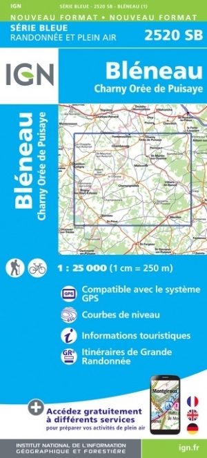
Wandelkaart 2520 SB Bléneau & Champignelles - IGN • 9782758548683
Wandelkaart - Bléneau & Champignelles Productomschrijving: Bléneau & Champignelles zijn gemeentes in het Franse departement Yonne in de regio Bourgogne-Franche-Comté. De plaats maakt deel uit van het arrondissement Auxerre. Tussen 2014 en 2018 vernieuwt IGN haar volledige collectie serie blauw. Een nieuwe toewijzing voor optimale leesbaarheid, met een grotere mate van geometrische nauw…