

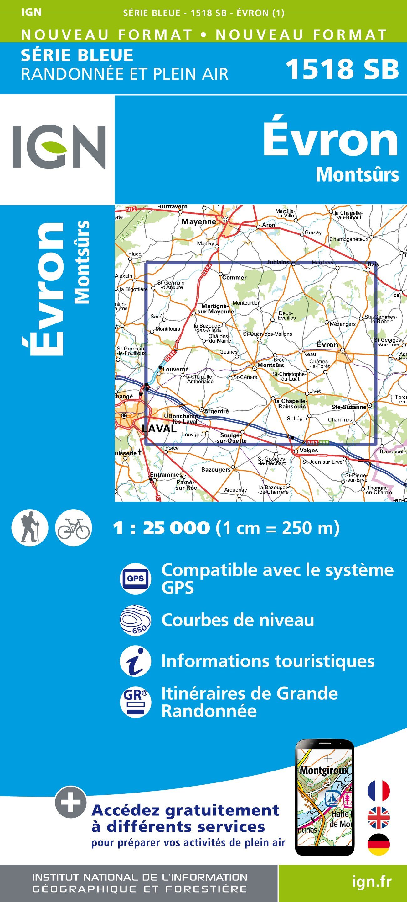
Wandelkaart 1518 SB Evron & Montsûrs - IGN
Evron & Montsûrs zijn gelegen in de Mayenne
Korte omschrijving
Wandelkaarten Pays-de-la-Loire, Frankrijk van Institut Géographique National. Ideaal voor tochten in Frankrijk.
Wandelkaart 1518 SB - Evron & Montsûrs - Nieuwe versie Productomschrijving: Deze topografische kaarten hebben een zeer nauwkeurige gronddetail, niet te vergeten de topografische hoogteprofie...

Specificaties
- Uitgever: Institut Géographique National
- ISBN-13: 9782758533764
- HOOFDCATEGORIEËN: Wandelkaart
- Activiteiten: Wandelen, Hiking & Trekking
- Regio: Pays-de-la-Loire, Frankrijk
- Land: Frankrijk
- Departement: Mayenne (53)
- Schaal: 1:25000
- Editie: 1
- Taal: Frans
- Reeks/Serie: IGN France > TOP25 Randoo / Série Bleue
- De Franse Regio's: Pays-de-la-Loire
Volledige omschrijving
Wandelkaart 1518 SB - Evron & Montsûrs - Nieuwe versie
Productomschrijving: Deze topografische kaarten hebben een zeer nauwkeurige gronddetail, niet te vergeten de topografische hoogteprofielen, die het wandelen een stuk gemakkelijker maken. Évron is een gemeente in het Franse departement Mayenne (regio Pays de la Loire) en telt 7283 inwoners (1999). De plaats maakt deel uit van het arrondissement Laval.
Desciptive produits: Ces cartes topographiques d'une très grande précision contiennent tous les détails existant sur le terrain : voies de communication jusqu'au moindre sentier, constructions jusqu'au hangar, bois, arbre isolé, rivière, source... Sans oublier la représentation du relief par des courbes de niveau.
Locatie op kaart
Overzichtskaarten
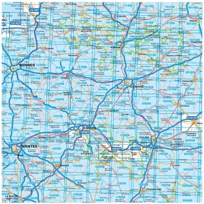
TOP25 et Série Blue ZONE B2
TOP25 et Série Blue ZONE B2
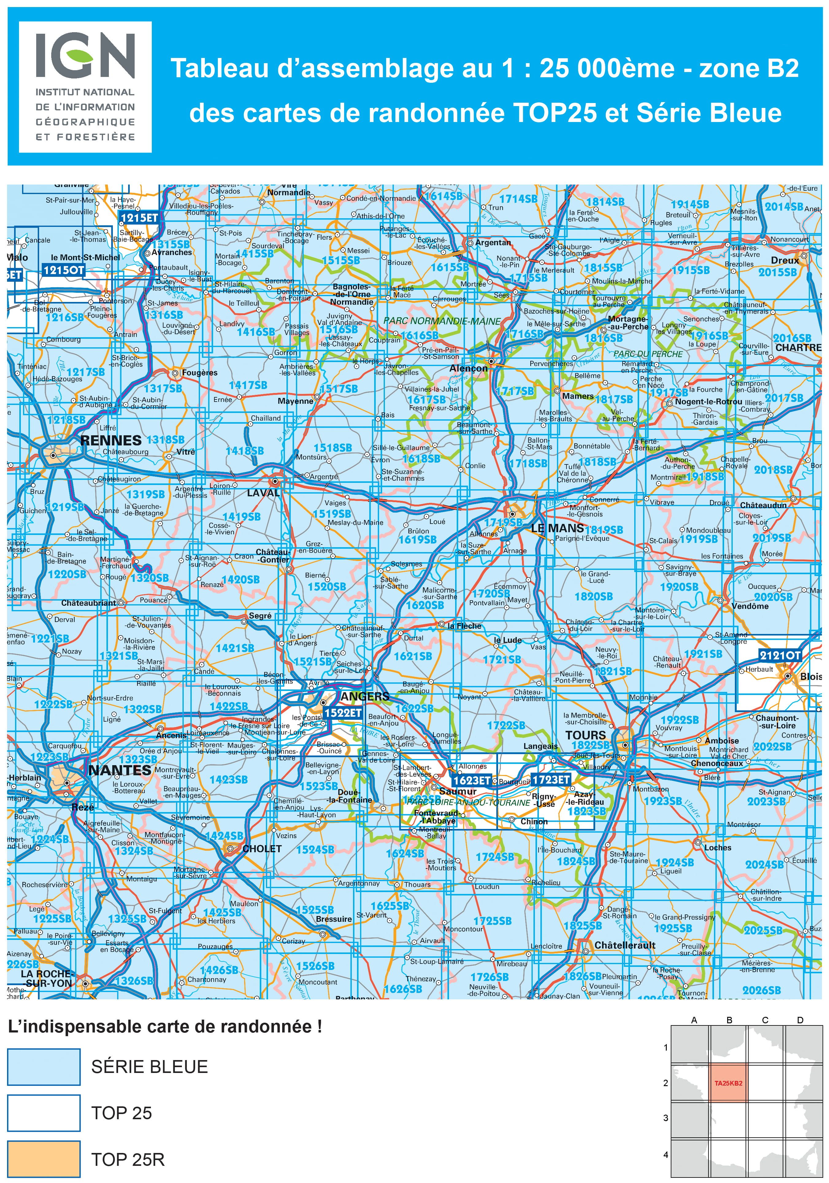
Producten op de overzichtskaart
Klik op een product om naar de detailpagina te gaan.
- Wandelkaart 1215 OT Le Mont-St-Michel & Dol-de-Bretagne - IGN
- Wandelkaart 1216 SB Pontorson & Dol-de-Bretagne - IGN
- Wandelkaart 1217 SB Combourg & St-Aubin-d'Augigné Bretagne - IGN
- Wandelkaart 1218 SB Rennes- Cesson-Sévigné & Liffré - IGN
- Wandelkaart 1219 SB Bruz & Janzé - IGN
- Wandelkaart 1221 SB Guémené & Penfao - IGN
- Wandelkaart 1222 SB Blain & Nort-sur-Erdre - IGN
- Wandelkaart 1223 SB Nantes & St-Herblain - IGN
- Wandelkaart 1223 SB Nantes - St-Herblain - IGN
- Wandelkaart 1224 SB St-Philbert-de-Grand-Lieu - IGN
- Wandelkaart 1225 SB Le Poiré-sur-Vie & Legé - IGN
- Wandelkaart 1226 SB Le Poiré-sur-Vie- Aizenay & Les Achards
- Wandelkaart 1315 SB Ducy-Brécey & Avranches - IGN
- Wandelkaart 1316 ET Milly-la-Forêt, Malesherbes & La Ferté-Alais
- Wandelkaart 1316 SB St-Hilaire-du-Harcouët - St-James - IGN
- Wandelkaart 1317 SB Fougères & St-Brice-en-Coglès - IGN
- Wandelkaart 1318 SB Vitré & Châteaubourg - IGN
- Wandelkaart 1319 SB La Guerche-de-Bretagne - IGN
- Wandelkaart 1320 SB Châteaubriant & Pouancé - IGN
- Wandelkaart 1321 SB St-Mars-la-Jaille - IGN
- Wandelkaart 1322 SB Ancenis & Riaillé - Frankrijk - IGN
- Wandelkaart 1323 SB Vallet & Gesté - IGN
- Wandelkaart 1324 SB Clisson & La Bruffière - IGN
- Wandelkaart 1325 SB Les Essarts & St-Fulgent - IGN
- Wandelkaart 1326 SB La Roche-sur-Yon & Bounezeau - IGN
- Wandelkaart 1415 SB Tinchebray-Bocage & Sourdeval - IGN
- Wandelkaart 1416 SB Le Teilleul & Landivy - IGN
- Wandelkaart 1417 SB Ernée & Gorron - IGN
- Wandelkaart 1418 SB Laval & Port Brillet - IGN
- Wandelkaart 1419 SB Cossé-le-Vivien & L'Huisserie - IGN
- Wandelkaart 1420 SB Craon & Chemazé - IGN
- Wandelkaart 1421 SB Segré & Candé - IGN
- Wandelkaart 1422 SB Chalonnes-sur-Loire - IGN
- Wandelkaart 1423 SB Chemillé & Beaupréau - IGN
- Wandelkaart 1424 SB Cholet & Mortagne-sur-Sèvre - IGN
- Wandelkaart 1425 SB Les Herbiers & Mauléon - IGN
- Wandelkaart 1426 SB Chantonnay - IGN
- Wandelkaart 1515 SB Flers & Briouze - IGN
- Wandelkaart 1516 SB Domfront & Lassay-les-Châteaux - IGN
- Wandelkaart 1517 SB Mayenne & Le Horps - IGN
- Wandelkaart 1518 SB Evron & Montsûrs - IGN
- Wandelkaart 1519 SB Meslay-du-Maine & Vaiges - IGN
- Wandelkaart 1520 SB Château-Gontier & Grez-en-Bouère - IGN
- Wandelkaart 1521 SB Le Lion-d'Angers - IGN
- Wandelkaart 1522 ET Angers - IGN
- Wandelkaart 1522 ET Angers France - IGN
- Wandelkaart 1523 SB Thouarcé & Valanjou - IGN
- Wandelkaart 1524 SB Vihiers & Yzernay - IGN
- Wandelkaart 1525 SB Bressuire & Cerizay - IGN
- Wandelkaart 1526 SB Moncoutant & La Chapelle-St-Laurent - IGN
- Wandelkaart 1614 SB Falaise & Morteaux-Couliboeuf - IGN
- Wandelkaart 1615 SB Argentan- Putanges & Pont-Ecrepin - IGN
- Wandelkaart 1616 SB La Ferté-Macé & Pré-en-Pail - IGN
- Wandelkaart 1617 SB Villaines-la-Juhel & St-Pierre-des-Nids - IGN
- Wandelkaart 1618 SB Sillé-le-Guillaume & Conlie Ste-Suzanne
- Wandelkaart 1619 SB Loué- Brûlon & Noyen-sur-Sarthe - IGN
- Wandelkaart 1620 SB La Flèche & Sablé-sur-Sarthe - IGN
- Wandelkaart 1622 SB Longué - Jumelles & Beaufort - IGN
- Wandelkaart 1623 ET Saumur- Bourgueil & Fontevraud-l'Abbaye
- Wandelkaart 1623 SB Saumur & Doué-la-Fontaine - IGN
- Wandelkaart 1624 SB Thouars & Le Puy-Notre-Dame - IGN
- Wandelkaart 1625 SB Thouars & Airvault - IGN
- Wandelkaart 1626 SB Parthenay & Thénezay - IGN
- Wandelkaart 1714 SB Vimoutiers & Trun - IGN
- Wandelkaart 1715 SB Sées & Gace - Bass-Normandie - IGN
- Wandelkaart 1716 SB Alençon & Sées - IGN
- Wandelkaart 1717 SB Alençon & Marolles-les-Braults - IGN
- Wandelkaart 1719 SB Le Mans & La Suze-sur-Sarthe - IGN
- Wandelkaart 1720 SB Ecommoy & Cérans-Fouilletourte - IGN
- Wandelkaart 1721 SB Le Lude & Château-la-Vallière - IGN
- Wandelkaart 1722 SB Noyant & Savigné-sur-Lathan - IGN
- Wandelkaart 1723 ET Chinon- Langeais & Azay-le-Rideau - IGN
- Wandelkaart 1724 SB Loudun & Richelieu - IGN
- Wandelkaart 1725 SB Lencloître & St-Jean-de-Sauves - IGN
- Wandelkaart 1726 SB Neuville-de-Poitou, Vouillé & Mirebeau - IGN
- Wandelkaart 1814 SB Rugles & La Ferté-Frênel - IGN
- Wandelkaart 1815 SB L'Aigle- Ste-Gauburge & Ste Colombe - IGN
- Wandelkaart 1816 SB Mortagne-au-Perche & Mêle-sur-Sarthe - IGN
- Wandelkaart 1817 SB Mamers - Bellême & Le Theil - IGN
- Wandelkaart 1818 SB La Ferté-Bernard & Bonnétable - IGN
- Wandelkaart 1819 SB Bouloire & Le Grand-Lucé - IGN
- Wandelkaart 1820 SB Château-du-Loir & La Chartre-sur-Loir- IGN
- Wandelkaart 1821 SB Château-du-Loir & Neuillé-Pont-Pierre- IGN
- Wandelkaart 1822 SB Tours & Langeais - IGN
- Wandelkaart 1823 SB Chambray-les-Tours & Langeais - IGN
- Wandelkaart 1824 SB Ste-Maure-de-Touraine & L'Ile-Bouchard IGN
- Wandelkaart 1825 SB Châtellerault & Descartes - IGN
- Wandelkaart 1825 SB Châtellerault & Descartes - IGN
- Wandelkaart 1914 SB Breteuil & La Neuve-Lyre - IGN
- Wandelkaart 1915 SB Verneuil-sur-Avre & Bourth - IGN
- Wandelkaart 1916 SB La Loupe & Rémalard-en-Perche - IGN
- Wandelkaart 1917 SB Nogent-le-Rotrou & Thiron-Gardais - IGN
- Wandelkaart 1918 SB Authon-du-Perche & La Bazoche-Gouët - IGN
- Wandelkaart 1919 SB St-Calais & Droué - IGN
- Wandelkaart 1920 SB Vendôme & Montoire-sur-le-Loir - IGN
- Wandelkaart 1921 SB Château-Renault & St-Amand-Longpré - IGN
- Wandelkaart 1922 SB Amboise & Montlouis-sur-Loire - IGN
- Wandelkaart 1923 SB Bléré- Chenonceaux & Veigné - IGN
- Wandelkaart 1924 SB Loches & Ligueil - IGN
- Wandelkaart 1925 SB Preuilly-sur-Claise & le Grand-Pressigny
- Wandelkaart 2014 SB St-André-de-l'Eure & Nonancourt - IGN
- Wandelkaart 2015 SB Dreux & Nonancourt - IGN
- Wandelkaart 2016 SB Chartres & Courville-sur Eure - IGN
- Wandelkaart 2017 SB Illiers-Combray & Bailleau-le-Pin - IGN
- Wandelkaart 2018 SB Châteaudun & Brou - IGN
- Wandelkaart 2019 SB Cloyes-sur-le-Loir - IGN
- Wandelkaart 2020 SB Selommes & St-Ouen - IGN
- Wandelkaart 2022 SB Montrichard & Contres - IGN
- Wandelkaart 2121 OT Blois- Chambord & Cheverny - IGN
- Wandelkaart 2121 OT Blois- Chambord & Cheverny - IGN
- Wandelkaart 2023 SB Montrichard & St-Aignan - IGN
- Wandelkaart 2024 SB Châtillon-sur-Indre - Ecueillé - IGN
- Wandelkaart 2025 SB Buzançais & Mézières-en-Brenne - IGN
- Wandelkaart 2026 SB Saint-Gaultier & Rosney - IGN
Artikelen uit dezelfde regio
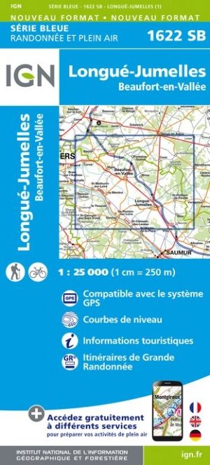
Wandelkaart 1622 SB Longué - Jumelles & Beaufort - IGN • 9782758536192
Wandelkaart 1622 SB - Longué - Jumelles & Beaufort Productbeschrijving: Longué, Jumelles & Beaufort-en-Vallée zijn gemeentes in het Franse departement Maine-et-Loire, regio Pays de la Loire. De plaats maakt deel uit van het arrondissement Saumur. Tussen 2014 en 2018, worden alle SERIE BLUE kaarten in de collectie vernieuwd. Een nieuwe kaart voor optimale leesbaarheid, met de precieze meetk…

Wandelgids Mayenne à pied Pays de la Loire - Ed. Chamina • 9782844663900
Wandelgids - Mayenne à pied Pays de la Loire - Ed. Chamina Productomschrijving: Het geheel van het departement Mayenne word in deze gids bezocht: Bocage mayennais, Haut-Maine et Pail, Pays de Mayenne, Pays de l'Ernée et de Loiron, Pays des Coëvrons, Pays de Laval, Pays du Maine angevin, Pays du Craonnais, Pays de Château-Gontier. De gids heeft een algemene Inleiding met de presentatie van …
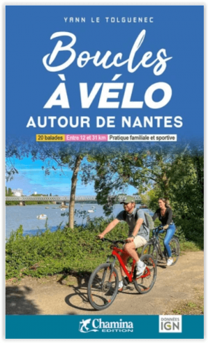
Fietsgids Autour de Nantes - Boucles à vélo - Ed. Chamina • 9782844666055
Autour de Nantes - Boucles à vélo - Ed. Chamina Productomschrijving: De Chamina fietslussen zijn routes van maximaal 30 km op gemengd terrein (wegen, paden, groene wegen) binnen ieders bereik: ideaal om VTC te oefenen en om met het gezin te fietsen! Deze gids neemt u mee op een tocht van 20 lussen rond Nantes. In deze voor fietsers zeer ontwikkelde stad zijn de routes vaak gemengd tussen …
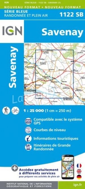
Wandelkaart 1122 SB Savenay - IGN • 9782758538646
Neiuwe versie - Wandelkaart 1122 SB - Savenay Productomschrijving: Savenay is een gemeente in het Franse departement Loire-Atlantique in de regio Pays de la Loire. In de achtertuin van Nantes gelegen is dit een perfecte uitvalsbasis voor wandelaars. De plaats ligt aansluitend op de PNR de Brière, en kan dus perfect een mountianbike kaart zijn, mocht de kaart over ingetekende routes beschik…

Wandelkaart Fietskaart TOP100 D49 Maine-et-Loire Pays-de-la-Loire - IGN • 9782758555575
Wandelkaart Fietskaart Maine-et-Loire - IGN Productomschrijving: Het departement van de Maine-et-Loire ligt in de regio Pays-de-la-Loire. Omvat: Angers- Saumur- Vallée de la Loire- PNR Loire-Anjou-Touraine. Franse omschrijving: Cette nouvelle édition possède un nouveau découpage départemental. Elle intègre les parcours vélo en partenariat avec l'association AF3V – VéloRoutes …