

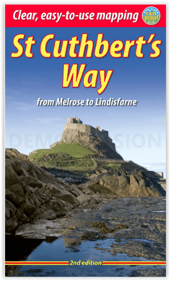
Wandelgids St-Cuthbert's Way Schotland - Rucksack Readers
From Melrose Abbey to the Holy Island of Lindisfarne - 101 km

Korte omschrijving
Wandelgidsen Schotse grenzen en Northumberland, Engeland van RUCKSACK READERS. Ideaal voor tochten in Schotland en England.
St-Cuthbert's Way Schotland - Rucksack Readers Productomschrijving: Volg in de voetsporen van St Cuthbert in deze gemakkelijke wandeling van 101 km, van Melrose Abbey in de Schotse Borders n...

Specificaties
- Uitgever: RUCKSACK READERS
- ISBN-13: 9781913817138
- HOOFDCATEGORIEËN: Wandelgids
- Activiteiten: Wandelen, Hiking & Trekking
- Auteur: Ronald Turnbull
- Regio: Northumberland, Engeland, Schotse grenzen
- Land: England, Schotland
- Lange afstand wandelroutes: St Cuthbert's Way (102 km)
- Schaal: 1:100000
- Editie: 2
- Taal: Engels
- Scotlands Great Trails: St Cuthbert's Way
Volledige omschrijving
St-Cuthbert's Way Schotland - Rucksack Readers
Productomschrijving: Volg in de voetsporen van St Cuthbert in deze gemakkelijke wandeling van 101 km, van Melrose Abbey in de Schotse Borders naar het Heilige Eiland Lindisfarne in Northumberland. St Cuthbert's Way is een van de Great Trails van Schotland en ook een van de Great Trails van Engeland. De route begint bij de ruïnes van Melrose Abbey, slingert langs de rivier de Tweed, en na ongeveer 31 mijl loopt u over de grens naar Engeland op hooggelegen terrein. De route omvat een deel van de Romeinse weg en passeert onderweg kastelen, heuvelforten en historische ruïnes. De meeste mensen kunnen de route gemakkelijk in 5 of 6 dagen afleggen.
Engelse omschrijving: Follow the footsteps of St Cuthbert in this easy-going walk of 63 miles (101 km) from Melrose Abbey in the Scottish Borders to the Holy Island of Lindisfarne in Northumberland. St Cuthbert’s Way is one of Scotland’s Great Trails, and it is also one of England’s great trails. Starting from the ruins of Melrose Abbey, it winds alongside the River Tweed, and after about 31 miles you walk across the border into England on high ground. The Way includes a section of Roman road and passes castles, hill forts and historic ruins along the way. Most people will complete it comfortably within 5 or 6 days.
Its summit is Wideopen Hill (369m/1210ft), and its barefoot finale is the Pilgrim Way to Lindisfarne with its priory and castle. The route is fully waymarked, the gradients are modest and it has welcoming B&Bs and pubs at strategic intervals. This second edition was thoroughly revised in 2023 and it contains custom mapping at 1:40,000 and many post-Covid updates. It is bound in our lighter, pocket-friendly format and printed on rainproof paper.
This guidebook has all you need to plan and enjoy the St Cuthbert’s Way:
- concise directions updated in 2023
- background on St Cuthbert’s life and times
- features on Lindisfarne, history and wildlife
- contact details for accommodation and transport
- detailed mapping on 16 pages (1:40,000)
- 100 glorious colour photos
- rainproof, rucksack-friendly format.
Locatie op kaart
Artikelen uit dezelfde regio
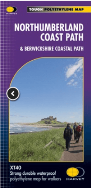
Wandelkaart Northumberland - Harvey Maps • 9781851376681
Wandelkaart Northumberland - Harvey Maps Productomschrijving: De Gehele route op één kaart! - Het Northumberland Coast Path strekt zich uit over 103 km van Cresswell in het zuiden naar Berwick-upon-Tweed in het noorden, waarna het Berwickshire Coastal Path 48 km (28 m) verdergaat naar Cockburnspath. Beide routes staan op deze kaart en ze maken deel uit van het Noordzeepad. Het Northumb…
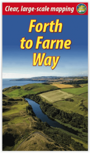
Wandelgids Forth to Farne Way - Schotland - Rucksack Readers • 9781898481966
Wandelgids Forth to Farne Way - Schotland Productomschrijving: Deze inspirerende pelgrimsroute van 110 mijl begint vanuit North Berwick aan de Firth of Forth bij Edinburgh en gaat verder via de 12e-eeuwse kerk van Whitekirk naar Dunbar. Het volgt de Noordzeekust naar het adembenemende landschap van St-Abb's Head en bezoekt Coldingham Priory, misschien wel het belangrijkste benedictijnenklo…

Wandelgids St Oswald's Way & Northumberland Coast Path - Cicerone • 9781786311559
St Oswald's Way & Northumberland Coast Path - Cicerone Productomschrijving: Deze gids beschrijft de St Oswald's Way en Northumberland Coast Paths, beide langeafstandswandelpaden door Northumberland. St Oswald's Way (156 km, 97 mijl) begint in Heavenfield en doorkruist delen van het Northumberland National Park en bezoekt Hadrian's Wall, de Simonside Hills en de prachtige Coquet Valley, voo…

Reisgids Go Slow Northumberland - Bradt travel guides • 9781804692530
Reisgids Northumberland England - Bradt Productomschrijving: The best-selling title in Bradt's award-winning series of Slow Travel guides to UK regions, the new third edition of this wide-ranging guidebook to Northumberland has been thoroughly updated by travel writer Gemma Hall, who grew up locally. With more castles than any other country, Britain's most ROman important monument (Hadrian…
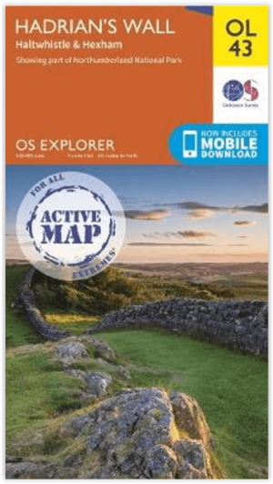

Wandelkaart OL43 Hadrian's Wall - OSI • 9780319475621
Wandelkaart Hadrian's Wall - England Productomschrijving: Wandel in de shaduw van de romeinen en ontdek dit eeuwen oud monument van om en bij de 2000 jaar oud. Hoogtepunten omvatten: Gilsland, Corbridge, Haltwhistle, Humshaugh, Hexham, Haydon Bridge, Bardon Mill, Greenlea lough, Housesteads, Chesters Roman Fort & Vindolanda. Een van de klassieke wandelingen van Engeland, en één die genotte…