

Wandelgids Dumfries and Galloway short walks - Cicerone
15 van de beste korte wandelingen rond Dumfries and Galloway


Korte omschrijving
Wandelgidsen Dumfries & Galloway, Schotland van CICERONE Press. Ideaal voor tochten in Schotland.
Dumfries and Galloway short walks - Cicerone Productomschrijving: Ronald Turnbull heeft 15 van de beste korte wandelingen rond Dumfries and Galloway voor je uitgezocht. Onze gids is voorzien...

Specificaties
- Uitgever: CICERONE Press
- ISBN-13: 9781786311726
- HOOFDCATEGORIEËN: Wandelgids
- Activiteiten: Wandelen, Hiking & Trekking
- Auteur: Ronald Turnbull
- Regio: Dumfries & Galloway, Schotland
- Land: Schotland
- Editie: 1
- Taal: Engels
Volledige omschrijving
Dumfries and Galloway short walks - Cicerone
Productomschrijving: Ronald Turnbull heeft 15 van de beste korte wandelingen rond Dumfries and Galloway voor je uitgezocht. Onze gids is voorzien van goed leesbare Ordnance Survey-kaarten en duidelijke routebeschrijvingen, perfect als je voor het eerst gaat wandelen of iets zoekt waar je met het hele gezin van kunt genieten.
We hebben informatie opgenomen over lokale schoonheidsplekjes en smakelijke verfrissingsstops, en de meeste wandelingen kunnen in minder dan 4 uur worden voltooid. We hebben geen wandelingen opgenomen met uitdagend terrein of ingewikkelde navigatie, en het enige wat je mee moet nemen zijn een waterdichte jas en een paar comfortabele sportschoenen.
Engelse omschrijving: Ronald Turnbull has chosen 15 of the best short walks around Dumfries and Galloway for you to explore. Our guide comes with easy-to-read Ordnance Survey maps and clear route descriptions, perfect if you're new to walking or are looking for something you can enjoy with the whole family.
We've included information on local beauty spots and tasty refreshment stops, and most of the walks can be completed in under 4 hours. We haven't included any walks with challenging terrain or complicated navigation, and all you'll need to take with you are a waterproof jacket and a pair of comfortable trainers.
Seasons
Year-round, some routes will be muddy in autumn and winter.
Centres
Portpatrick, Newton Stewart, Gatehouse of Fleet, Kirkcudbright, Castle Douglas, Dumfries, Annan
Difficulty
Routes are on paths throughout. These vary between smooth well-surfaced ones and some that are more rugged. One route (Balcary Bay) is close above clifftops and Criffel summit is a substantial climb.
Must See
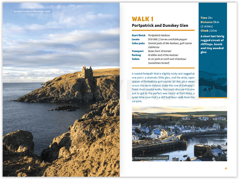
Beautiful coastline, Criffel summit, Sweetheart Abbey, the old sandstone towns of Gatehouse of Fleet, Newton Stewart and Castle Douglas, the great rivers Nith and Annan, the ancient Wood of Cree.

Artikelen uit dezelfde regio
Wandelgids 019 Pathfinder guides Dumfries & Galloway - OS • 9780319091180
Wandelgids Dumfries & Galloway Schotland - OS Productomschrijving: Dumfries and Galloway form the South-west of Scotland, a broad wedge of land jutting out into the Irish Sea between the Solway Firth and the Firth of Clyde. The area is also part of Scotland's border country a peaceful, unspoilt region that possesses a mild climate, a great variety of scenery and a rich historic legacy. …

Wandelkaart 321 Nithsdale & Dumfries & Thornhill - OSI • 9780319245736
Wandelkaart Nithsdale & Dumfries - Thornhill Dumfries Omvat ook: Thornhill Productomschrijving: OS Explorer kaart 321 omvat Dumfries te Thornhill. Het gebied staat bekend als Nithsdale, want het is de vallei van de rivier de Nith. De indrukwekkende Drumlanrig Castle is het hele jaar geopend, of er zijn wandelpaden over het Nithsdale gebied. De OS Explorer kaart voor Nithsdale & Dumfrie…
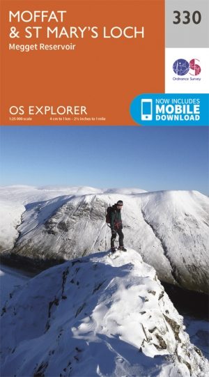
Wandelkaart 330 Moffat & St Mary's Loch - Dumfries - OSI • 9780319245828
Wandelkaart Moffat & St Mary's Loch - Schotland Omvat ook: Megget Reservoir Productomschrijving: Omvat Moffat in Dumfries and Galloway, Schotland. OS Explorer kaart 330 omvat ook St. Mary's Loch, Megget Reservoir en deel van de Southern Upland Way, een lange afstand wandelroute. De OS Explorer kaart voor Moffat & St Mary's Loch is beschikbaar in zowel de standaard papieren versie als …

Wandelgids The Annandale Way - Schotland - Rucksack Readers • 9781913817169
The Annandale Way - Schotland - Rucksack Readers Productomschrijving: De Annandale Way is één van de Great Trails van Schotland, een charmante lange wandeling in een weinig bekend, maar zeer toegankelijk deel van Zuid-Schotland. De route strekt zich uit van de bron van de rivier Annan tot aan de zee, begint in het schapenstadje Moffat en loopt 56 mijl (90 km) zuidwaarts via Lochmaben. …

Reisgids Go Slow Dumfries & Galloway - Bradt travel guides • 9781804692721
Reisgids Dumfries & Galloway - Bradt Productomschrijving: Written by Southern Scotland experts, this new, thoroughly updated third edition of Bradt's Dumfries & Galloway (Slow Travel) remains the only full-blown guide to this beguiling southwest corner of Scotland. The region is covered in depth, from Eskdale in the east to Scotland's southern tip at the Mull of Galloway, via Annandal…