
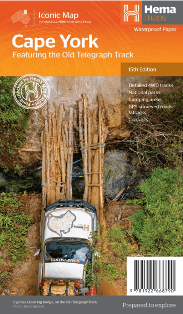
Landkaart Wegenkaart Cape York NP Queensland Australia - Hema
CREB Track and Rinyirru (Lakefield) National Park
Korte omschrijving
Wandelkaarten Queensland, Noord-Oost Australië van Hema Maps. Ideaal voor tochten in Australië.
Cape York NP northern Queensland Australia - Hema Productomschrijving: Featuring the Old Telegraph Track! This brand new edition of Hema’s best-selling Cape York map, on durable waterpr...

Specificaties
- Uitgever: Hema Maps
- ISBN-13: 9781922668790
- HOOFDCATEGORIEËN: Wegenkaart - Landkaart
- Activiteiten: Wandelen, Hiking & Trekking
- Regio: Queensland, Noord-Oost Australië
- Land: Australië
- Nationale parken: Cape York peninsuala, NP, Northern Queensland Australia
- Schaal: 1:1000000
- Editie: 15
- Taal: Engels
- De Australische Regio's: Queensland
Volledige omschrijving
Cape York NP northern Queensland Australia - Hema
Productomschrijving: Featuring the Old Telegraph Track!
This brand new edition of Hema’s best-selling Cape York map, on durable waterproof paper, features our latest mapping and points of interest in a new cartographic style. It now features new inset maps for the CREB Track and Rinyirru (Lakefield) National Park. It combines Hema’s entire database of roads and 4WD tracks with touring points of interest and topographic information. Also included are camping areas, national parks, accommodation and distances.
Key features:
• Detailed 4WD tracks
• National parks
• Camping areas
• GPS surveyed roads & tracks
What’s new in this edition:
•New cartographic style with latest mapping, points of interest and facilities.
•New inset maps for the CREB Track and Rinyirru (Lakefield) National Park.
Locatie op kaart
Artikelen uit dezelfde regio
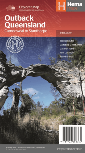
Landkaart Wegenkaart Explorer Map Queensland Outback - Hema Maps • 9781922668769
Explorer Map Queensland Outback - Hema Productomschrijving: Outback Queensland (QLD) contains mapping and visitor information for one of the most iconic regions in Australia. Mapping at a scale of 1:1,500,000 covers from the inland borders to Toowoomba in the east and Charters Towers in the north, with hill shading and elevation tinting creating a more realistic interpretation of the land…

Landkaart Wegenkaart Australië Indigenous Journeys Map - Hema Map • 9781922668936
Wegenkaart Australië Indigenous Journeys Map - Hema Maps Productomschrijving: Australië Indigenous Journeys Map hema 1:5.5M Ontdek de zanglijnen van de oudste levende cultuur ter wereld Al meer dan 65.000 jaar bewandelen Aboriginals en Torres Strait Islanders - de traditionele eigenaars van Australië - het land, smeden handelsroutes, delen kennis en zorgen voor het land. De Indigenou…
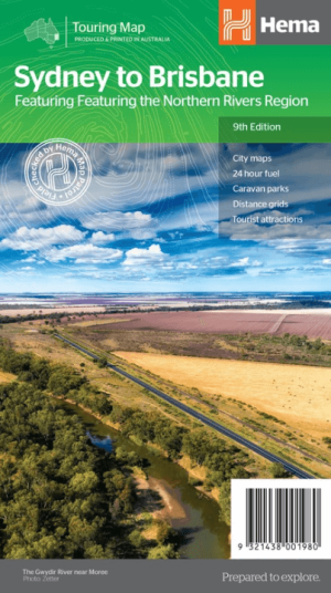
Landkaart Wegenkaart Sydney tot Brisbane - Hema Maps • 9321438001980
Wegenkaart Sydney tot Brisbane - Hema Productomschrijving: A city to city map designed for the journey from Sydney to Brisbane via the Pacific and New England Highways (1:1,000,000), with tourist information on towns and regions within the trip on the opposite side. Omvat: The Northern Rivers Region! • City maps • 24-hour fuel • Camping areas • Distance grids • Tourist att…

Wegenatlas Cape York Atlas & Guide - Hema Maps • 9781876413439
Wegenatlas Cape York Atlas & Guide - Hema Productomschrijving: Hema Maps’ Cape York Atlas & Guide helps you make the most of your visit to this remarkable part of Australia. With detailed coverage of The Tip, the coast from the Cairns region to Cooktown, Rinyirru (Lakefield) National Park, the Peninsula Developmental Road, Old Telegraph Track, Torres Strait and the Savannah Way, it en…

Landkaart Wegenkaart Queensland state map - Hema Maps • 9781922668806
Wegenkaart Queensland state map - Hema Productomschrijving: The thirteenth edition of Hema’s Queensland State Map features Hema’s distinctive and informative maps fully, all of which have been field checked by Hema’s Map Patrol to ensure the best possible accuracy with the latest mapping data. A fully indexed state map of Queensland (QLD) at a scale of 2:500,000. Marked on the mapping…