

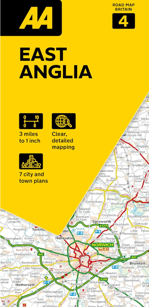
Landkaart Wegenkaart 04 East Anglia - AA Road Maps
Road Map of East Anglia
Korte omschrijving
Wegenkaart 04 East Anglia - AA Road Maps Productomschrijving: AA Road Map East Anglia is a practical and slimline, foldable map from the experts at the AA. Encased in a durable, weatherproof...

Specificaties
- Uitgever: AA Publishing
- ISBN-13: 9780749584672
- HOOFDCATEGORIEËN: Wegenkaart - Landkaart
- Activiteiten: Street/Road maps & city plans
- Regio: East Anglia, England
- Land: England
- Schaal: 1:200000
- Taal: Engels
- Reeks/Serie: AA Road maps Britain
Volledige omschrijving
Wegenkaart 04 East Anglia - AA Road Maps
Productomschrijving: AA Road Map East Anglia is a practical and slimline, foldable map from the experts at the AA. Encased in a durable, weatherproof cover, the mapping is produced at a scale of 3 miles to 1 inch (1:200,000 / 2km to 1cm) combining clear design, an easy-to-read scale and more road detail to ensure that you never lose your way.
Also included are toll points, service areas, road numbers, motorways, dual carriageways and wide narrow local roads, National Parks and other places of interest.
• Fully updated speed camera locations, plus speed cameras with speed limits shown
• Clear place name index
• 8 city and town plans
• Caravan & camping sites are pinpointed on the mapping
• National Parks and places of interest are also highlighted
• National Trust, English Heritage, Scottish and Welsh Heritage sites shown
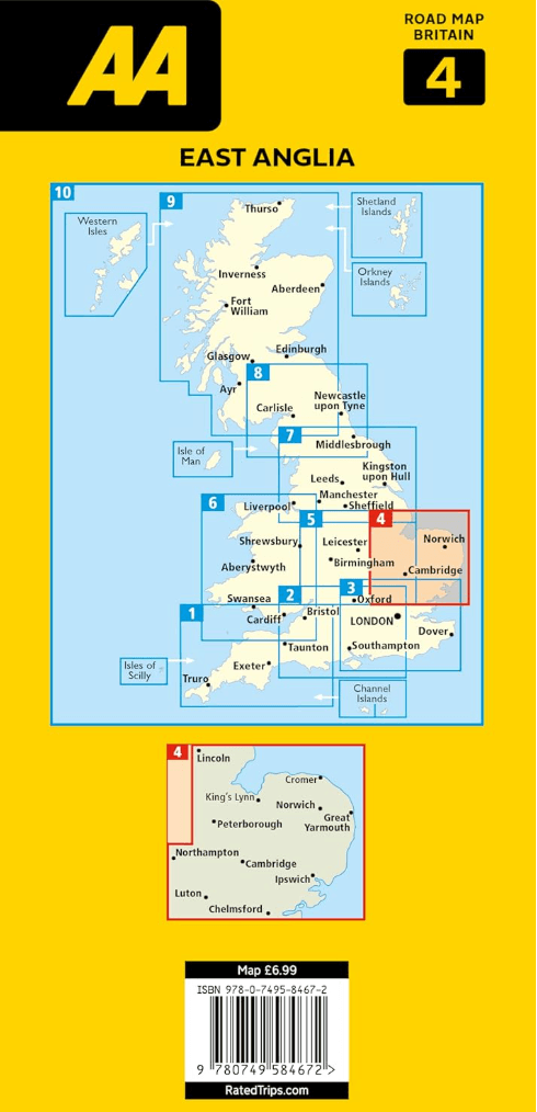
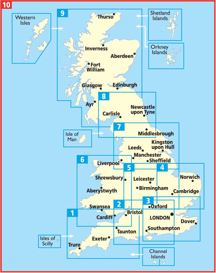
Road Map Map East Anglia is one in a series of expertly produced road maps of Britain from the AA.
Overzichtskaarten

Wegenkaarten Landkaarten Road Maps Britain 1 > 10
Wegenkaarten Landkaarten Road Maps Britain 1 > 10
Producten op de overzichtskaart
Klik op een product om naar de detailpagina te gaan.
- Landkaart Wegenkaart 01 West Country & Wales Zuid - AA Road Maps
- Landkaart Wegenkaart 02 Engeland, Centraal Zuid - AA Road Maps
- Landkaart Wegenkaart 03 Engeland Zuid Oost - AA Road Maps
- Landkaart Wegenkaart 04 East Anglia - AA Road Maps
- Landkaart Wegenkaart 05 Midlands & Engeland Centraal - AA Road
- Landkaart Wegenkaart 06 Wales - AA Road Maps
- Landkaart Wegenkaart 07 Engeland Noord - AA Road Maps
- Landkaart Wegenkaart 08 Engeland Noord & Scottish Borders
- Landkaart Wegenkaart 09 Schotland - AA Road Map
- Landkaart Wegenkaart 10 Groot-Brittannië - AA Road Map
Artikelen uit dezelfde regio

Wandelgids Day Walks in East Anglia - Vertebrate Publ. • 9781839810114
Day Walks in East Anglia - Vertebrate Productomschrijving: Day Walks in East Anglia by Anna Paxton features 20 routes in Norfolk and Suffolk suitable for hillwalkers of all abilities. Together with stunning photography, each route features Ordnance Survey 1:25,000 maps, easy-to-follow directions, distance and navigation information, refreshment stops and local information. Researched a…

Reisgids Go Slow Cambridgeshire & The Fens - Bradt • 9781784777456
Go Slow Cambridgeshire & The Fens - Bradt gudes Productomschrijving: Dit nieuwe boek voegt Cambridgeshire and the Fens toe aan Bradt's bekroonde Slow Travel serie - de grootste serie Britse regionale reisgidsen, nu al meer dan 20 titels sterk. Geen enkele andere titel biedt zo veel en zo diepgaande informatie over deze gevarieerde, mooie en verrassend onontdekte regio. Cambridge zelf …

Landkaart Wegenkaart 504 S.E. Engeland & East Anglia - Michelin • 9782067183322
Regionale Wegenkaart South East Engeland & East Anglia Productomschrijving: De volledig bijgewerkte MICHELIN-kaart van Engeland Zuid-Oost, Midlands, Oost-England geeft u alle WEG- EN TOERISME-informatie die u nodig hebt om uw reizen in deze regio te optimaliseren: een INDEX VAN LOCATIES, een TABEL VAN AFSTANDEN en REISTIJDEN. Dankzij de schaal van 1:400.000 (1 cm = 4 km) kun je zowel de h…

Wandelgids The Ridgeway National Trail - Trailblazer Publ. • 9781912716524
The Ridgeway National Trail - Trailblazer Publications Productomschrijving: The Ridgeway: Avebury to Ivinghoe Beacon - 53 maps - 46 colour photos, - 4pp colour flower & butterfly guide An 87-mile (139km) National Trail, the Ridgeway runs from Overton Hill near Avebury in Wiltshire to Ivinghoe Beacon in Buckinghamshire. Part of this route follows Britain’s oldest road, dating b…

Wandelkaart Cotswold Way - Harvey maps • 9781851374182
Wandelkaart Cotswold Way - Chipping Campden to Bath - Harvey maps Productomschrijving: Toont de gehele 166km (103miles) van The Cotswold Way, door de Cotswolds van Chipping Campden naar Bath, Broadway, Winchcombe, Stroud, Wooton-under-Edge en Chipping Sodbury passeren. Informatie over het vinden van accommodatie, camping, voedsel. Routebeschrijving naar het begin. Ook Ranger Service en…