

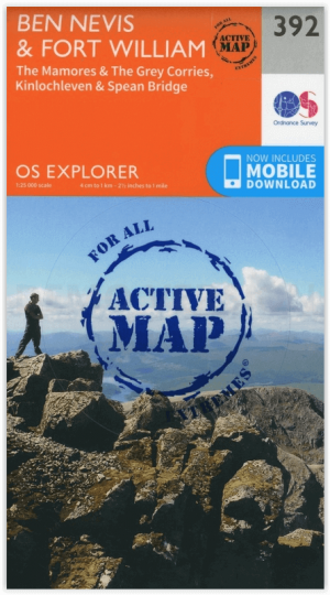
Wandelkaart 392 Ben Nevis & Fort William- Highlands - OSI
Omvat het bergachtige gebied van Ben Nevis & Fort William

Korte omschrijving
Wandelkaarten Highlands, Schotland van Ordnance Survey. Ideaal voor tochten in Schotland.
Wandelkaart Ben Nevis & Fort William - Highlands Schotland Productbeschrijving: The Mamores & The Grey Corries Kinlochleven & Spean Bridge. 392 / Ben Nevis & Fort William, Highlands, S...

Specificaties
- Uitgever: Ordnance Survey
- ISBN-13: 9780319246351
- HOOFDCATEGORIEËN: Wandelkaart
- Activiteiten: Wandelen, Hiking & Trekking
- Regio: Highlands, Schotland
- Land: Schotland
- TOPO's & Stafkaarten: Topografisch wandelen
- Schaal: 1:25000
- Taal: Engels
- Reeks/Serie: Explorer Series OS
- Iconische Bergketens van Europa: De Schotse Highlands
- Iconische Wandelroutes: Ben Nevis, Schotland
Volledige omschrijving
Wandelkaart Ben Nevis & Fort William - Highlands Schotland
Productbeschrijving: The Mamores & The Grey Corries Kinlochleven & Spean Bridge.
392 / Ben Nevis & Fort William, Highlands, Schotland - Kaart nummer 392 in de OS Explorer kaart reeks is de perfecte kaart om te gebruiken bij het verkennen van het bergachtige gebied van Ben Nevis, Fort William, The Mamores en The Grey keteldalen Kinlochleven Spean Bridge. Het gebied werd bezocht door bergbeklimmers en wandelaars of diegenen die willen genieten van het landschap.
392 / Ben Nevis & Fort William, Highlands, Schotland - Map sheet number 392 in the OS Explorer map series is the perfect map to use when exploring the mountainous area of Ben Nevis, Fort William, The Mamores and The Grey Corries Kinlochleven and Spean Bridge. The area is frequented by mountain climbers and hikers or those wishing to soak up the scenery.
'The Ben' is Britain's highest mountain; spectacular, challenging, iconic and awe-inspiring. At the top you'll be rewarded by panoramic views across the Scottish highlands and the satisfaction of having climbed the big one. Containing the end sections of the West Highland Way and part of the Great Glen Way, this OS Explorer Map also contains the area around Fort William, and the forests and mountains to the north and west of Ben Nevis including 20 of the Munros such as Stob Ban, Binnein Mor, Càrn Mor Dearg, Aonach Mòr, and Aonach Beag.
Highlights of the area include: Ben Nevis, Glen Nevis, River Nevis, Loch Leven, The Munros, Kinlochleven, Glen Coe, Loch Leven Heritage Trail, The Mamores, The Grey Corries, Spean Brideg, Loch Leven, and Ballachulish.
Locatie op kaart
Gekoppelde artikelen

Wandelkaart 392 Ben Nevis & Fort William- Highlands - OSI • 9780319246351
standaard versieWandelkaart Ben Nevis & Fort William - Highlands Schotland Productbeschrijving: The Mamores & The Grey Corries Kinlochleven & Spean Bridge. 392 / Ben Nevis & Fort William, Highlands, Schotland - Kaart nummer 392 in de OS Explorer kaart reeks is de perfecte kaart om te gebruiken bij het verkennen van het bergachtige gebied van Ben Nevis, Fort William, The Mamores en The Grey keteldale…
Wandelkaart 392 Ben Nevis- Highland's Schotland - OSI • 9780319472552
weatherproof versieWandelkaart Ben Nevis- Highland's Schotland - OSI The Mamores & The Grey Corries Kinlochleven & Spean Bridge. Productbeschrijving: Kaart nummer 392 in de OS Explorer kaart reeks is de perfecte kaart om te gebruiken bij het verkennen van het bergachtige gebied van Ben Nevis, bij Fort William, The Mamores en The Grey Corries Kinlochleven Spean Bridge. Het gebied word bezocht door bergbek…
Overzichtskaarten

OSI Explorer & Explorer Active - Ben Nevis - Glen Coe
OSI Explorer & Explorer Active - Ben Nevis - Glen Coe
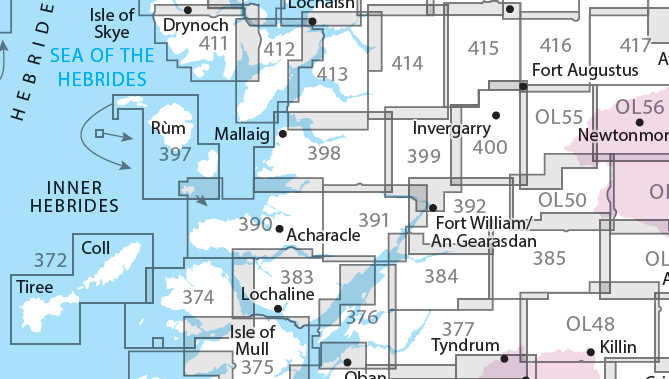
Producten op de overzichtskaart
Klik op een product om naar de detailpagina te gaan.
- Wandelkaart 372 Coll & Tiree- Ayrshire & Lanark - OSI
- Wandelkaart 374 Isle of Mull North & Tobermroy - OSI
- Wandelkaart 376 Oban & North Lorn- Argyl & Bute - OSI
- Wandelkaart 377 Loch Etive & Glen Orchy- Schotland- OSI
- Wandelkaart 383 Morvern & Lochaline- Highland's - OSI
- Wandelkaart 384 Glen Coe & Glen Etive- Highlands - OSI
- Wandelkaart 385 Rannoch Moor & Ben Alder- Highland's - OSI
- Wandelkaart 390 Ardnamurchan- Highlands Schotland - OSI
- Wandelkaart 391 Ardgour & Strontian- Highlands - OSI
- Wandelkaart 392 Ben Nevis & Fort William- Highlands - OSI
- Wandelkaart 397 Rum- Eigg- Muck- Canna & Sanday - OSI
- Wandelkaart 398 Loch Morar & Mallaig- Highland's - OSI
- Wandelkaart 399 Loch Akraig- Lochaber Schotland - OSI
- Wandelkaart 400 Loch Lochy & Glen Roy- Highlands - OSI
- Wandelkaart 413 Knoydart- Loch Hourn & Loch Duich - OSI
- Wandelkaart 414 Glen Shiel & Kintail Forest- Highlands- OSI
- Wandelkaart 415 Glen Affric & Glen Moriston - OSI
- Wandelkaart 416 Inverness & Loch Ness - OSI
- Wandelkaart OL50 Ben Alder, Loch Ericht & Laggan - OS
- Wandelkaart OL55 Loch Laggan, Creag Meagaidh & Corrieyairack - OS
- Wandelkaart OL56 Badenoch, Upper Strathspey & Kingussie - OS
Artikelen uit dezelfde regio
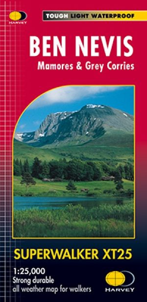
Wandelkaart XT25 Ben Nevis - Mamores - Harvey maps • 9781851374021
Wandelkaart Ben Nevis - Mamores - Harvey maps Productomschrijving: HARVEY Superwalker kaart op 1: 25.000 schaal, is een gedetailleerde kaart van de Ben Nevis. De kaart voor wandelaars en klimmers dekt Fort William door Glen Nevis naar Loch Treig. Vanuit het zuiden Grey keteldalen naar Kinlochleven. Ben Nevis, de Aonachs en de Mamores zijn onder de 20 Munros en 4 Corbetts. Duidelijke en gem…

Wandelkaart 435 An Teallach & Slioch- Schotland - OSI • 9780319246672
Wandelkaart An Teallach & Slioch - Schotland Productbeschrijving: 435 - An Teallach & Slioch , Schotland - OS Explorer kaart 435 omvat van Loch Broom down tot Kinlochewe, de nationale Scenic area van Wester Ross. Als u van plan bent om de Munros in te pakken, staan er op deze kaart 10, ondanks er weinig gemarkeerde paden zijn, zodat navigatie kennis essentieel is! De OS Explorer kaart …

Wandelkaart XT25 Fannichs Seana Bhraigh - Harvey Maps • 9781851376209
Wandelkaart XT25 - Fannichs Seana Bhraigh & Ben Wyvis - Harvey Maps Productomschrijving: Een locatie in de Noordelijke Schotse Highlands, gelegen bij de bekende berg Ben Wyvis, meerbepaald ten oostenlijke Ross, noordwestelijk gelegen van Dingwall in het noorden van Schotland. Opgelet, deze locaties zijn voor ervaren hikers, de locatie is niet geschikt voor onervaren mensen. De precieze…
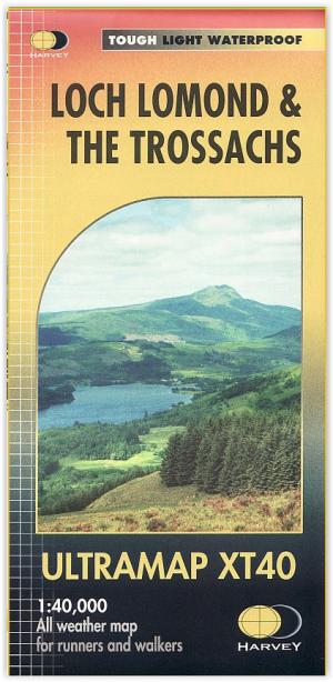
Wandelkaart XT40 - Loch Lomond & The Trossachs - Harvey Maps • 9781851376254
Wandelkaart XT40 - Loch Lomond & The Trossachs - Harvey Maps Productomschrijving: Omvat een groot gebied maar is praktisch en compact, zakformaat. Gedetailleerde kaart voor lopers en wandelaars van het Nationaal Park Loch Lomond & the Trossachs. Bevat de meest zuidelijke Munro van Schotland, Ben Lomond en een inzet kaart voor de toegang tot Ben Vorlich van Loch Earn. Ideaal voor de Great T…

Reisgids Scottish Highlands & Islands - Rough guides • 9780241272312
Scottish Highlands & Islands - Rough guides Product description: This fully updated The Rough Guide to Scottish Highlands and Islands is the ultimate guidebook to the captivating remote reaches of Scotland. From the divine seafood offerings at Loch Fyne to the whisky distilleries on Islay, this is a place for indulging. It’s also a hotspot for outdoor activities, whether you decide to bag …