

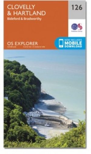
Wandelkaart 126 Clovelly & Hartland Devon - OSI
Omvat Clovelly- Bideford- Hartland & Bradworthy


Korte omschrijving
Wandelkaarten Devon, England van Ordnance Survey. Ideaal voor tochten in England.
Wandelkaart Clovelly & Hartland - Devon England - OSI Productbeschrijving: - Bideford & Bradworthy. 126 / Clovelly & Hartland, Devon, England - Kaart blad nummer 126 in de OS Explorer re...

Specificaties
- Uitgever: Ordnance Survey
- ISBN-13: 9780319243220
- HOOFDCATEGORIEËN: Wandelkaart
- Activiteiten: Wandelen, Hiking & Trekking
- Regio: Devon, England
- Land: England
- TOPO's & Stafkaarten: Topografisch wandelen
- Schaal: 1:25000
- Taal: Engels
- Reeks/Serie: Explorer Series OS
- De Engelse Graafschappen: Devon
Volledige omschrijving
Wandelkaart Clovelly & Hartland - Devon England - OSI
Productbeschrijving: - Bideford & Bradworthy.
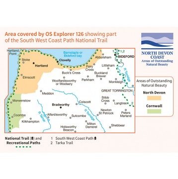
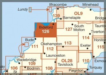
126 / Clovelly & Hartland, Devon, England - Kaart blad nummer 126 in de OS Explorer reeks omvat Clovelly, Bideford, Hartland, Bradworthy en great Torrington. Hoogtepunten van het gebied zijn onder andere: Noord-Devon en Cornwall AONB, rivier Torridge en Tamar, Hartland punt, Barnstaple en Bideford Bay en Coombe. Omvat ook een deel van de South West Coast Path. De OS Explorer kaart voor Clovelly & Hartland is beschikbaar in zowel de standaard papieren versie als de weerbestendige 'Actief' versie.
126 / Clovelly & Hartland, Devon, England - Map sheet number 126 in the OS Explorer series covers Clovelly, Bideford, Hartland, Bradworthy and Great Torrington. Highlights of the area include: North Devon and Cornwall AONB, River Torridge and Tamar, Hartland Point, Barnstaple and Bideford Bay and Coombe. Also includes part of the South West Coast Path. The OS Explorer map for Clovelly & Hartland is available in both the standard paper version and weatherproof 'Active' version.
Locatie op kaart
Gekoppelde artikelen
Wandelkaart 126 Clovelly & Hartland Devon - OSI • 9780319243220
standaard versieWandelkaart Clovelly & Hartland - Devon England - OSI Productbeschrijving: - Bideford & Bradworthy. 126 / Clovelly & Hartland, Devon, England - Kaart blad nummer 126 in de OS Explorer reeks omvat Clovelly, Bideford, Hartland, Bradworthy en great Torrington. Hoogtepunten van het gebied zijn onder andere: Noord-Devon en Cornwall AONB, rivier Torridge en Tamar, Hartland punt, Barnstaple e…

Wandelkaart 126 Clovelly & Hartland- Devon England - OSI • 9780319470015
weatherproof versieWandelkaart Clovelly & Hartland - Devon England - OSI Productbeschrijving: Kaart nummer 126 in de OS Explorer reeks omvat Clovelly, Bideford, Hartland, Bradworthy en great Torrington. Hoogtepunten van het gebied zijn onder andere: Noord-Devon en Cornwall AONB, rivier Torridge en Tamar, Hartland punt, Barnstaple en Bideford Bay en Coombe. Ook omvat een deel van de South West Coast Path. De …
Artikelen uit dezelfde regio

Wandelgids 026 Pathfinder guides Dartmoor National Park - OS • 9780319090305
Wandelgids Dartmoor National Park Devon - OS Productomschrijving: Discover the rugged, iconic landscape of Dartmoor National park, with this selection of 28 walks designed to help you find the best it has to offer. While largely uninhabited wilderness with few villages, farms and roads, there are still plenty of opportunities for walks of all levels. Some of the most significant featu…
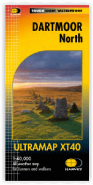
Wandelkaart XT40 Ultra - Dartmoor NP Noord - Harvey Maps • 9781851376322
Wandelkaart XT40 Ultra - Dartmoor NP Noord - Harvey Maps Productomschrijving: Omvat een groot gebied, maar de kaart is wel zeer praktisch en compact en in zakformaat - De kaart omvat gedetailleerde informatie voor lopers en wandelaars van het noordelijk deel van Dartmoor National Park. Omvat eveneens Dartmoor's bekende Tors waaronder Haytor Rocks, Yes Tor & High Willhays. Archaeologisc…

Wandelgids Part 2 SWCP Map Booklet St Ives to Plymouth - Cicerone • 9781786312785
Map Booklet Part 2 SWCP - St Ives to Plymouth - Cicerone Productomschrijving: Map of part of the southern section of the 630 mile (1014km) South West Coast Path National Trail. Covers: the trail from St Ives to Plymouth along the west Cornwall and Devon coastline. This convenient and compact booklet of Ordnance Survey 1:25,000 maps shows the route, providing all of the mapping you ne…

Fietskaart Dartmoor National Park - Harvey maps • 9781851374540
Fietskaart - Dartmoor National Park - Harvey maps Productomschrijving: Eén zijde voor mountainbiken, en één zijde voor cyclustoeren, deze stevige, duurzame en waterdichte kaart van Dartmoor en het omliggende gebied is specifiek gemaakt voor het buitenleven. Gemaakt in samenwerking met Dartmoor National Park autoriteit, toont de berg vele off-road fietsroutes. De cyclustouringszijde toont h…
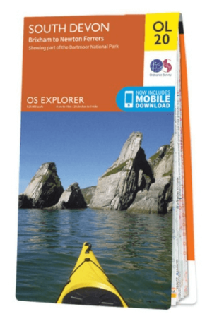
Wandelkaart OL20 South Devon & Dartmoor NP - OS • 9780319242599
Wandelkaart South Devon - OS Productomschrijving: South Devon, Dartmoor National Park and parts of the South West Coast Path SWCP, South Devon AONB and Tamar Valley AONB. Omvat: Brixham to Newton Ferrers, Avon Estuary Walk, Co-operative Way, Dart Valley Trail, E9 European Long Distanse Path, Erme-Plym Trail, Greenway Walk, John Musgrave Heritage Trail, Plymouth Cross-City Link, South …