

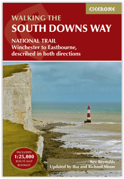
Wandelgids The South Downs Way - Cicerone
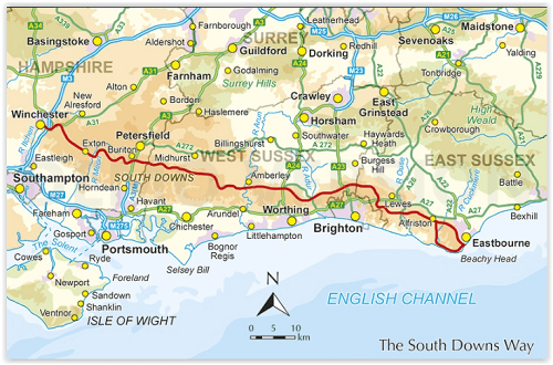
Tussen Winchester en Eastbourne - 160 km - 12 etappes
Korte omschrijving
Wandelgidsen South England en Sussex, England van CICERONE Press. Ideaal voor tochten in England.
The South Downs Way - Cicerone Productomschrijving: Wandelgids over de South Downs Way National Trail, een route van 100 mijl (160 km) tussen Winchester en Eastbourne door het South Downs Na...

Specificaties
- Uitgever: CICERONE Press
- ISBN-13: 9781786311610
- HOOFDCATEGORIEËN: Wandelgids
- Activiteiten: Wandelen, Hiking & Trekking
- Auteur: Ilsa Moon, Kevin Renolds, Richard Moon
- Regio: South England, Sussex, England
- Land: England
- Lange afstand wandelroutes: South Down's Way, (160 km)
- Nationale parken: South Downs NP, Sussex Egland
- Schaal: 1:25000
- Editie: 5
- Taal: Engels
- De Nationale Parken: South Downs National Park, England
- De Engelse Graafschappen: East Sussex
- National Trails UK, England & Wales: South Downs Way, England
Volledige omschrijving
The South Downs Way - Cicerone
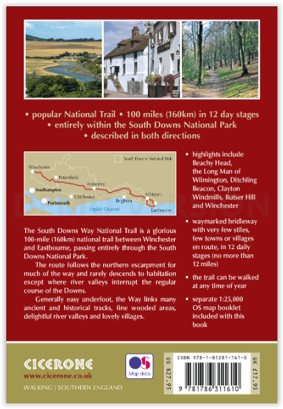
Productomschrijving: Wandelgids over de South Downs Way National Trail, een route van 100 mijl (160 km) tussen Winchester en Eastbourne door het South Downs National Park, beschreven in beide richtingen over 12 etappes. Gemakkelijke wandelingen over oude en historische paden, langs beboste gebieden, prachtige rivierdalen en mooie dorpjes. Met 1:25K OS kaartenboekje.
Engelse omschrijving: Guidebook to walking the South Downs Way National Trail, a 100 mile (160km) route between Winchester and Eastbourne through the South Downs National Park, described in both directions over 12 stages. Easy walking on ancient and historical tracks, taking in wooded areas, delightful river valleys and pretty villages. With 1:25K OS map booklet.
Seasons:
Can be walked at all times of year - this is one of the driest and warmest parts of England.
Centres:
Eastbourne, Alfriston, Lewes, Amberley, Burint, Exton, Winchester.
Difficulty:
The South Downs Way is a waymarked bridleway; very few stiles, few towns/villages en route: 12 stages (max length 12 miles).
Must See Must SeeBeachy Head, Long Man of Wilmington, Ditchling Beacon, Clayton Windmills, Butser Hill, Winchester.
Locatie op kaart
Artikelen uit dezelfde regio

Landkaart Wegenkaart 02 Engeland, Centraal Zuid - AA Road Maps • 9780749584658
Wegenkaart Engeland, Centraal Zuid - AA Road Maps Productomschrijving: AA Road Map Central Southern England is a practical and slimline, foldable map from the experts at the AA. Encased in a durable, weatherproof cover, the mapping is produced at a scale of 3 miles to 1 inch (1:200,000 / 2km to 1cm) combining clear design, an easy-to-read scale and more road detail to ensure that you never…

Wandelkaart OL33 Haslemere & Petersfield - OS • 9780319242735
Wandelkaart Crawley & Horsham - Ordnance Survey Productomschrijving: Crawley, Horsham, Cranleigh, Billinghurst & part of the South Downs National Park. Omvat: Crawley, Horsham, Cranleigh, Billinghurst, The AONB regions of the Surrey Hills and High Weald, part of the South Downs National Park, Downs Link, Greensand Way, High Weald Landscape Trail, Serpent Trail, Sussex Border Path, Sus…

Fietsgids South East Mountain Biking - Vertebrate Publ. • 9781906148638
South East Mountain Biking - Vertebrate Productomschrijving: South East Mountain Biking - North and South Downs contains 24 routes between 16 and 35 km in length that are suitable for all levels of mountain bikers. Each route features industry-standard 1:50,000 Ordnance Survey maps, easy-to-follow directions, details of distance, times and difficulty and information on refreshment stops a…
Wandelgids 066 Pathfinder guides West Sussex & South Downs - OS • 9780319091746
Wandelgids West Sussex & South Downs AONB - OS Productomschrijving: Containing 28 circular, graded walks that have all been created and tested by experienced walkers, this walking guidebook is ideal for both visitors and locals. The routes range from extended strolls to exhilarating hikes, so there is something for everyone. Each route includes a detailed description, the Ordnance Survey …

Wandelgids South Downs Way Map Booklet - Cicerone • 9781786311658
The South Downs Way, Map Booklet - Cicerone The guidebook INCLUDES a copy of this map booklet. Productomschrijving: Kaart van de 100 mijl (160 km) lange South Downs Way National Trail, tussen Eastbourne en Winchester. Dit boekje is bijgesloten bij de Cicerone gids voor het pad en toont de volledige route op OS 1:25.000 kaarten. De wandeling duurt meestal een week en is geschikt voor de…