

Fietsgids South East Mountain Biking - Vertebrate Publ.
The North and South Downs National Park


Korte omschrijving
Fietsgidsen Sussex, England, Surrey South England en Kent South East England van Vertebrate Publishing. Ideaal voor tochten in England.
South East Mountain Biking - Vertebrate Productomschrijving: South East Mountain Biking - North and South Downs contains 24 routes between 16 and 35 km in length that are suitable for all l...

Specificaties
- Uitgever: Vertebrate Publishing
- ISBN-13: 9781906148638
- HOOFDCATEGORIEËN: Fietsgids
- Activiteiten: Fietsen / VTT / MTB
- Auteur: Nick Cotton
- Regio: Kent South East England, Surrey South England, Sussex, England
- Land: England
- Nationale parken: South Downs NP, Sussex Egland
- Taal: Engels
- Fietsen: Fietsen in het Buitenland
- VTT / MTB: Mountainbike
Volledige omschrijving
South East Mountain Biking - Vertebrate
Productomschrijving: South East Mountain Biking - North and South Downs contains 24 routes between 16 and 35 km in length that are suitable for all levels of mountain bikers. Each route features industry-standard 1:50,000 Ordnance Survey maps, easy-to-follow directions, details of distance, times and difficulty and information on refreshment stops and local facilities.
South East Mountain Biking - North and South Downs is the second edition of the bestselling guide to some of the finest mountain biking in the South East of England. Delve into the woodland singletrack on the North Downs or head out to the big, rolling chalk hills that make up the newly-created South Downs National Park.
The guide contains 24 rotues between 16 and 35km in length that are suitable for all levels of mountain bikers. All route information has been thoroughly checked for this new edition to give the most up-to-date and comprehensive guidebook to the area. Ridden, researched and written by highly-experienced guidebook author Nick Cotton, each route features industry-standard 1:50,000 Ordnance Surveymapping, easy-to-follow directions, details of distance, times and difficulty and information on refreshment stops and local facilities. Also included are Top Ten descents, climbs and mountain bike playgrounds, as well as an introduction to the fantastic Surrey Hills singletrack.

Artikelen uit dezelfde regio

Wandelkaart 147 Sevenoaks & Tonbridge- Kent - OSI • 9780319243404
Wandelkaart Sevenoaks & Tonbridge - Kent England Omvat ook: Royal Tunbridge Wells & Westerham. Productbeschrijving: Kaart nummer 147 in de OS Explorer reeks heeft betrekking op drie gebieden van uitzonderlijke natuurlijke schoonheid AONB: de Kent Downs, High Weald en de Surrey Uills. De North Downs Way passeert ten noorden van Sevenoaks. Andere hoogtepunten zijn: Royal Tonbridge Wells,…

Wandelgids Surrey UK - 50 walks - AA Publishing • 9780749583286
Wandelgids Surrey UK - AA Publishing Productomschrijving: Wandelen is een van de favoriete vrijetijdsbestedingen in Groot-Brittannië en deze gids bevat een verscheidenheid aan uitgestippelde wandelingen voor alle niveaus. Het boek bevat alle praktische details die u nodig hebt, vergezeld van boeiende achtergrondinformatie over de geschiedenis en de flora en fauna van het gebied, en duideli…
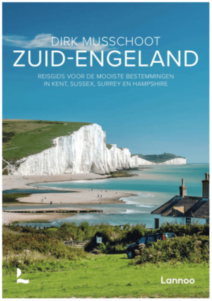
Reisgids Zuid-Engeland - Uitgeverij Lannoo • 9789059960978
Reisgids Zuid-Engeland - Lannoo Productomschrijving: Engelandkenner Dirk Musschoot laat je op een onovertroffen wijze kennismaken met de regio's Kent, East en West Sussex, Surrey, Hampshire en het eiland Wight, en de bestemmingen die je daar absoluut niet mag missen. Enkele voorbeelden: de optrekjes van Charles Darwin, Winston Churchill en Rudyard Kipling, de imposante kliffen van Beac…

Wandelgids South Downs Way Map Booklet - Cicerone • 9781786311658
The South Downs Way, Map Booklet - Cicerone The guidebook INCLUDES a copy of this map booklet. Productomschrijving: Kaart van de 100 mijl (160 km) lange South Downs Way National Trail, tussen Eastbourne en Winchester. Dit boekje is bijgesloten bij de Cicerone gids voor het pad en toont de volledige route op OS 1:25.000 kaarten. De wandeling duurt meestal een week en is geschikt voor de…

Reisgids Dorset, Hampshire & Isle of Wight - Rough Guides • 9781835290170
Reisgids Dorset, Hampshire & Isle of Wight Productomschrijving: From sweeping beaches to medieval forests, country pubs to seaside hotels, The Rough Guide to Dorset, Hampshire & the Isle of Wight is the ultimate guide to this stunning part of England. Our expert authors show you all the region’s highlights and let you in on the secret spots locals love, with the fully updated listings show…