

Wandelgids Thames Valley walking guide - Cicerone
25 dagwandelingen in de Thames Valley & de North Hampshire Downs


Korte omschrijving
Wandelgidsen South & South East England en Thames Valley, England van CICERONE Press. Ideaal voor tochten in England.
Wandelgids - Thames Valley walking guide - Cicerone Productomschrijving: Deze handige gids biedt 25 avontuurlijke dagwandelingen in de Thames Valley, die betrekking hebben op de North Hampsh...

Specificaties
- Uitgever: CICERONE Press
- ISBN-13: 9781852845704
- HOOFDCATEGORIEËN: Wandelgids
- Activiteiten: Wandelen, Hiking & Trekking
- Regio: South & South East England, Thames Valley, England
- Land: England
- Editie: 1
- Taal: Engels
Volledige omschrijving
Wandelgids - Thames Valley walking guide - Cicerone
Productomschrijving: Deze handige gids biedt 25 avontuurlijke dagwandelingen in de Thames Valley, die betrekking hebben op de North Hampshire Downs, Berkshire en de zuidelijke Chilterns met gemakkelijke toegang tot Londen. De circulaire wandelingen variëren van 10 tot 18 mijl, waaronder een twee-daagse trot, evenals kortere route opties voor degenen die een minder vermoeiende dag willen.
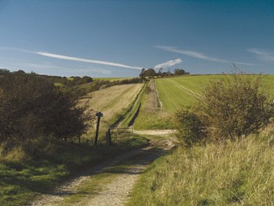
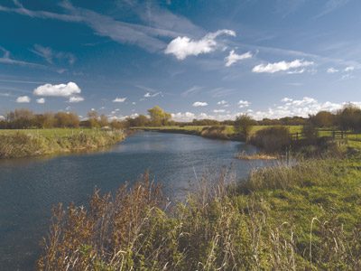
Detail: De rivier de Thaims stroomt door sommige spectaculaire gebieden van platteland met inbegrip van open krijtgrasland, broadleaved bos- en landbouwgrond. Het gebied is ook de thuis van twee gebieden of (AONB) Area of Outstanding Natural Beauty: the Chilterns en de North Wessex Downs. De 25 avontuurlijke wandelingen nemen u door de zuidelijke Chilterns, Berkshire, Lambourn, de North Hampshire Downs en zuidelijke Oxfordshire, allemaal binnen handbereik van Reading, Newbury, Abingdon en Londen.
Product description: Walking in the Thames Valley describes 25 adventurous day walks in the area covering the North Hampshire Downs, Berkshire and the Southern Chilterns with easy access to London and Reading. The circular walks vary from 10 to 18 miles, including one 2-day walk, as well as shorter route options for those who want a less strenuous day out.
Seasons:
Spring and autumn offer the best walking conditions and clearer skies. In winter some paths may become impassable after heavy rain due to flooding, especially along the Thames.
Centres:
Reading, Newbury, Abingdon, London.
Difficulty:
Walks range from 10 to 18 miles, with one 26-mile, 2-day option, all on good paths. Many routes also have shorter options.
Must See:
The Chilterns and North Wessex Downs Areas of Outstanding Natural Beauty, the World Heritage Site at Avebury, the Uffington White Horse, lots of cosy pubs and ancient churches.

Locatie op kaart
Artikelen uit dezelfde regio

Wandelgids - North Downs Way - Map Booklet - Cicerone • 9781852849559
Wandelgids - North Downs Way - Map Booklet - Cicerone Productomschrijving: Kaart van de 208km, over de North Downs Way National Trail, tussen Farnham en Dover, met inbegrip van een optioneel bezoek aan Canterbury. Dit boekje is opgenomen in de Cicerone gids en toont het volledige parcours op OS 1: 25.000 kaarten. Een van de eenvoudigere nationale routes, dat comfortabel kan worden gelopen …

Fietsgids Cycling Days Out - South East England - Vertebrate Publ • 9781906148249
Cycling Days Out - South East England - Vertebrate Productomschrijving: Traffic-free family and leisure cycling in Kent, Sussex, Surrey & Hampshire. Cycling Days Out – South East England is a guide to traffic-free family and leisure cycling in Kent, Sussex, Surrey and Hampshire. Written by local author Deirdre Huston, it explores tourist trails, country parks, forest riding and more. …

Mountainbikegids South Downs - 26 off road routes - Cicerone • 9781852846459
Mountainbikegids South Downs - 26 off road routes - Cicerone Productomschrijving: Een gids voor berg (MTB) fietsroutes op de South Downs van Hampshire en Sussex, tussen Winchester, Brighton en Eastbourne. De 26 routes beschreven in dit boek nemen deel aan achtbanen, toegewijde bos singletrack en grote afdalingen. Ritten worden gequoteerd voor alle vaardigheden met informatie over plaatseli…

Fietsgids 20 Rides in South East England - Cicerone • 9781852847432
Cycle the best Sportive routes in South East England Productomschrijving: Deze gids biedt 20 sportieve wielerroutes in de meest uitdagende en mooie fietsgebieden van Zuidoost-Engeland. Van Surrey en de Chiltern Hills naar het New Forest en de Berkshire Downs, het gebied heeft km's van fietsvriendelijke wegen geschikt voor sportieve training. De gesorteerde routes zijn allemaal op rustige l…

Landkaart Wegenkaart 504 S.E. Engeland & East Anglia - Michelin • 9782067183322
Regionale Wegenkaart South East Engeland & East Anglia Productomschrijving: De volledig bijgewerkte MICHELIN-kaart van Engeland Zuid-Oost, Midlands, Oost-England geeft u alle WEG- EN TOERISME-informatie die u nodig hebt om uw reizen in deze regio te optimaliseren: een INDEX VAN LOCATIES, een TABEL VAN AFSTANDEN en REISTIJDEN. Dankzij de schaal van 1:400.000 (1 cm = 4 km) kun je zowel de h…