

Mountainbikegids South Downs - 26 off road routes - Cicerone
26 MTB routes door de Zuidelijke South Downs UK


Korte omschrijving
Fietsgidsen South & South East England en South East England van CICERONE Press. Ideaal voor tochten in England.
Mountainbikegids South Downs - 26 off road routes - Cicerone Productomschrijving: Een gids voor berg (MTB) fietsroutes op de South Downs van Hampshire en Sussex, tussen Winchester, Brighton ...

Specificaties
- Uitgever: CICERONE Press
- ISBN-13: 9781852846459
- HOOFDCATEGORIEËN: Fietsgids
- Activiteiten: Fietsen / VTT / MTB
- Regio: South & South East England, South East England
- Land: England
- Editie: 1
- Taal: Engels
- De Nationale Parken: South Downs National Park, England
- De Engelse Graafschappen: East Sussex
- VTT / MTB: Mountainbike, Vélo Tout Terrain
Volledige omschrijving
Mountainbikegids South Downs - 26 off road routes - Cicerone
Productomschrijving: Een gids voor berg (MTB) fietsroutes op de South Downs van Hampshire en Sussex, tussen Winchester, Brighton en Eastbourne. De 26 routes beschreven in dit boek nemen deel aan achtbanen, toegewijde bos singletrack en grote afdalingen. Ritten worden gequoteerd voor alle vaardigheden met informatie over plaatselijke voorzieningen en MTB versnelling en voorbereidingen.
De South Downs is een mountainbikers paradijs. De routes in deze gids nemen fietsers over achtbanen, over ruggen met prachtig uitzicht op het kanaal; zigzaggen rond specifieke bos singletracks, en van de drukte van fantastische afdalingen, en bieden een wisselende uitdaging door een mooi en divers landschap.
Engelse omschrijving: A guide to mountain biking (MTB) routes on the South Downs of Hampshire and Sussex, between Winchester, Brighton and Eastbourne. The 26 routes described in the book take in roller coaster rides, dedicated woodland singletrack and great downhills. Rides are graded for all abilities with information on local facilities and MTB gear and preparation.
Seasons:
Excellent all year round, with each season bringing its own experiences but prolonged rainy periods can turn the chalky soil into highly-adhesive mud.
Centres:
Eastbourne, Alfriston, Seaford, Lewes, Newhaven, Brighton, Worthing, Arundel, Amberley, Chichester, Petersfield, Cocking, East Meon, East Dean, New Alresford, Winchester.
Difficulty:
Routes primarily aimed at experienced mountain bikers with a good level of fitness; most manageable for the less experienced/fit with extra time; graded by length: short, half-day and day; as well as strenuousness: medium, hard and very hard.
Must See:
Endless chalk bridleways along Downland ridges with great views in every direction; challenging hills and exhilarating descents; great dedicated singletrack at Friston Forest, Queen Elizabeth Country Park, Wild Park and Stanmer Park; excellent pubs and cafés for re-fuelling.
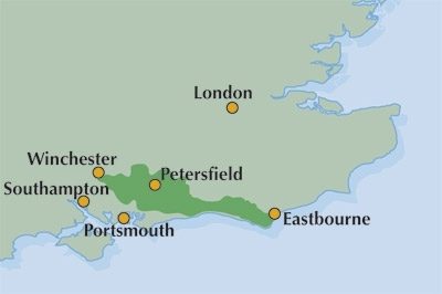
Locatie op kaart
Artikelen uit dezelfde regio

Wandelkaart OL22 New Forest- Southampton & Ringwood - OSI • 9780319475782
Wandelkaart New Forest national park - Southampton - OSI Productomschrijving: Kaart nummer OL22 in de OS Explorer kaartenserie is de perfecte kaart voor vakantiegangers en dagjesmensen om te gebruiken bij een bezoek aan het New Forest Nationaal Park in West Engeland. Het nationale park is beroemd om zijn uitstekende wandelingen en ritten en is de thuisbasis van New Forest pony's en heidela…

Wandelkaart 144 Basingstoke Alton & Whitchurch- Hampshire • 9780319470169
Wandelkaart Basingstoke- Alton & Whitchurch - Hampshire England Omvat ook: Odiham, Overton & Hook. Productbeschrijving: Kaart nummer 144 in de OS Explorer kaarten reeks heeft betrekking op een gebied in het noorden van Hampshire, van Whitchurch in het westen tot Odiham en Alton in het Oosten, en betrekken de stad van Basingstoke. De Wayfarer's walk kruist de North Wessex Downs, een geb…

Wandelgids Cheddar & the Mendips - 15 short walks - Cicerone • 9781786312549
Wandelgids 15 short walks Cheddar & the Mendips - Cicerone Productomschrijving: Would you like to explore the best of Cheddar and the Mendips? This guidebook covers 15 of the best short walks in the area (between 3 and 10km, all under three hours), including Crook Peak and King's Wood, Beacon Batch and Velvet Bottom, Ebbor Gorge and Ebbor Wood, Cheddar Gorge North and Piney Sleights and th…

Wandelkaart OL22 New Forest National Park - OS • 9780319263921
Wandelkaart New Forest National Park - OS Productomschrijving: New Forest National Park, Hampshire England. Omvat: Southampton, Ringwood, Ferndown, Lymington, Christchurch and Bournemouth, parts of the New Forest National Park. Ontdek de OL-serie van Ordnance Survey: De OL-serie (Outdoor Leisure) van Ordnance Survey is dé referentie voor wie gaat wandelen op de Britse eilanden. D…

Wandelkaart Ridgeway National Trail SE England - Harvey maps • 9781851374786
Wandelkaart Ridgeway National Trail SE England - Harvey maps Productomschrijving: Toont de gehele route van de Ridgeway op één plan, vanaf Overton Hill in de buurt van Avebury in Wiltshire naar Ivinghoe Beacon, ten oosten van Tring in Hertfordshire 137 km (85 mijl). Geschikt voor wandelaars, fietsers en ruiters. Informatie over het vinden van accommodatie, camping, voedsel. Routebeschrijvi…