

Wandelgids Nidderdale short walks - Cicerone
15 van de beste korte wandelingen rond Nidderdale Yorkshire Dales

Korte omschrijving
Wandelgidsen Yorkshire, England van CICERONE Press. Ideaal voor tochten in England.
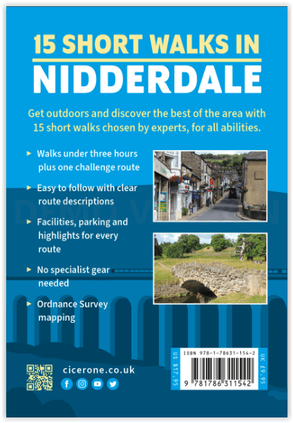
Nidderdale short walks - Cicerone Productomschrijving: Jon Fallis heeft 15 van de beste korte wandelingen rond Nidderdale in de Yorkshire Dales voor u uitgezocht. Onze gids is voorzien van g...

Specificaties
- Uitgever: CICERONE Press
- ISBN-13: 9781786311542
- HOOFDCATEGORIEËN: Wandelgids
- Activiteiten: Wandelen, Hiking & Trekking
- Auteur: Jon Fallis
- Regio: Yorkshire, England
- Land: England
- Nationale parken: Yorkshire Dales NP, England
- AONB - Area of Outstanding Beauty/National Landscape: Nidderdale AONB
- Editie: 1
- Taal: Engels
Volledige omschrijving
Nidderdale short walks - Cicerone
Productomschrijving: Jon Fallis heeft 15 van de beste korte wandelingen rond Nidderdale in de Yorkshire Dales voor u uitgezocht. Onze gids is voorzien van goed leesbare Ordnance Survey-kaarten en duidelijke routebeschrijvingen, perfect als u voor het eerst gaat wandelen of iets zoekt waar u met het hele gezin van kunt genieten. We hebben informatie opgenomen over lokale mooie plekjes en lekkere verfrissingsstops, en de meeste wandelingen kunnen in minder dan 3 uur worden voltooid.
We hebben geen wandelingen opgenomen met uitdagend terrein of ingewikkelde navigatie, en het enige wat je mee moet nemen is een waterdichte jas en een paar comfortabele sportschoenen.
Engelse omschrijving: Jon Fallis has chosen 15 of the best short walks around Nidderdale in the Yorkshire Dales for you to explore. Our guide comes with easy-to-read Ordnance Survey maps and clear route descriptions, perfect if you're new to walking or are looking for something you can enjoy with the whole family. We've included information on local beauty spots and tasty refreshment stops, and most of the walks can be completed in under 3 hours.
We haven't included any walks with challenging terrain or complicated navigation, and all you'll need to take with you are a waterproof jacket and a pair of comfortable trainers.
Seasons
The walks in this book can be enjoyed all year round, but some routes can be muddy, especially in winter. Bluebell woods are a highlight of spring and moorland heather blooms in August/September.
Centres
Ilkley, Otley, Harrogate, Knaresborough, Ripon, Masham, Pateley Bridge
Difficulty
All walks are easy to access and usually well signposted. The majority are at lower level, although a few venture higher. The only challenging or steep terrain is found at Hackfall Woods, situated on a steep river bank. Some walks feel isolated and many can be muddy, but none are far from refreshment.
Must See
An area full of contrasts: spectacular landforms such as Brimham Rocks and the Nidd Gorge; human design at Studley, Jerveaux and Coldstones Cut; the peace and isolation of Dallowgill, Colsterdale and Dacre Banks; and picturesque towns and villages including Pateley Bridge, Masham and Ripley
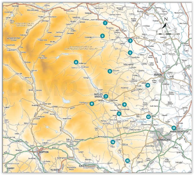
Locatie op kaart
Artikelen uit dezelfde regio
Wandelgids The Cleveland Way Map Booklet - Cicerone • 9781786312228
The Cleveland Way Map Booklet - Cicerone Productomschrijving: Kaartboekje van de Cleveland Way National Trail, een 177 km lange wandeling rond het North York Moors National Park. Dit boekje is inbegrepen bij de Cicerone gids voor de Cleveland Way en de Yorkshire Wolds Way en toont de volledige route van de Cleveland Way op OS 1:25.000 kaarten. Dit kaart Boekje zit reeds gratis bijgevoe…

Wandelgids 15 Short Walks in the Yorkshire Dales – Cicerone • 9781786312327
15 Short Walks in the Yorkshire Dales – Cicerone Productomschrijving: Would you like to explore the best of Grassington, Skipton, Malham and Ilkley? This guidebook covers 15 of the best short walks in the Yorkshire Dales (all under three hours), including Bolton Abbey, Malham Cove, Gordale Scar, Ilkley Moor, the Cow and Calf rocks, Grassington lead mines and Trollers Gill. Why choose …

Wandelkaart OL2 - Yorkshire Dales- Southern & Western Areas - OSI • 9780319475331
Wandelkaart Yorkshire Dales- Southern & Western Areas - OSI Productomschrijving: Kaart nummer OL2 in de OS Explorer kaartenserie is de ideale kaart om te gebruiken bij het verkennen van de zuidelijke en westelijke gebieden van de Yorkshire Dales, waaronder Whernside, Ingleborough en Pen-y-ghent. Hoogtepunten: De drie pieken van Yorkshire, The Devils Bridge bij Kirkby Lonsdale, Leeds to Liv…

Wandelgids 093 Pathfinde North Yorkshire Accessible walks - OS • 9780319092859
Wandelgids North Yorkshire Accessible walks - OS Productomschrijving: This guide comprises 33 beautiful walks, ranging in distance from 0.5 to 8 miles, across North Yorkshire, with ten routes in the Yorkshire Dales National Park, eleven in the North York Moors National Park, North Sea coast routes at Whitby, Robin Hood’s Bay and Bempton, and routes handily placed near the Richmond, Ripon, …

Wandelgids The Cleveland Way - Rucksack Readers • 9781898481973
Wandelgids Cleveland Way - Rucksack Readers Productomschrijving: De Cleveland Way is één van de oudste en meest geliefde National Trails van Engeland. De route loopt over een afstand van 174 km rond het North York Moors National Park en begint in het binnenland bij Helmsley, met een panoramisch uitzicht over de valleien van York en Mowbray en vanaf de Cleveland Hills. Na de kust bij Saltb…