

Wandelgids The Pennine Way - Trailblazer
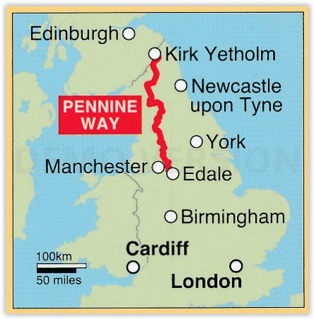
Edale (Peak District) tot Kirk Yetholm Scotisch borders - 420 km

Korte omschrijving
Wandelgidsen Cumbria & Lake District, England, Derbyshire & Peak District, England, Northumberland, Engeland en Yorkshire, England van Trailblazer Publications. Ideaal voor tochten in England.
The Pennine Way 420 km - Trailblazer Productomschrijving: De Pennine Way, het bekendste nationale pad van Groot-Brittannië, slingert zich 420 km over woeste heidevelden en door stille dalen ...

Specificaties
- Uitgever: Trailblazer Publications
- ISBN-13: 9781912716333
- HOOFDCATEGORIEËN: Wandelgids
- Activiteiten: Wandelen, Hiking & Trekking
- Auteur: Bradley Mayhew, Stuart greig
- Regio: Cumbria & Lake District, England, Derbyshire & Peak District, England, Northumberland, Engeland, Yorkshire, England
- Land: England
- Lange afstand wandelroutes: Pennine Way (420 km)
- Editie: 6
- Taal: Engels
- National Trails UK, England & Wales: Pennine Way, England
Volledige omschrijving
The Pennine Way 420 km - Trailblazer
Productomschrijving: De Pennine Way, het bekendste nationale pad van Groot-Brittannië, slingert zich 420 km over woeste heidevelden en door stille dalen langs de ruggengraat van Noord-Engeland. Het begint in Edale in het Peak District en eindigt net over de grens in Schotland bij Kirk Yetholm. Dit prachtige wandelpad doorkruist 3 nationale parken - het Peak District, Yorkshire Dales en Northumberland - en toont het mooiste hooglandlandlandschap van Groot-Brittannië, terwijl het ook het literaire landschap van de familie Brontë en de Romeinse geschiedenis langs Hadrian's Wall raakt.
Engelse omschrijving: Pennine Way: Edale to Kirk Yetholm (British Walking Guide)
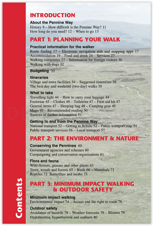
- 138 trail maps - 12 town plans - 15 stages maps with profiles and 2 overview maps- 60 colour photos - colour flower guide
The Pennine Way, Britain’s best-known National Trail, winds for 253 miles (420 km) over wild moorland and through quiet dales following the backbone of northern England. It begins in Edale in the Peak District and ends just over the border in Scotland at Kirk Yetholm. Crossing three national parks – the Peak District, Yorkshire Dales and Northumberland – this superb footpath showcases Britain’s finest upland scenery, while touching the literary landscape of the Brontë family and Roman history along Hadrian’s Wall.
- Post pandemic, stay-cations remain the holidays of choice
- Mapping now in new two-colour style
- All-in-one guide
Trailblazer guides include practical information not usually found in walking guides to the UK: reviews of places to stay, places to eat, attractions along the way and detailed public transport information showing all access points on the path and car parks near the trail, for weekend and day walkers. The largest scale walking maps available – At just under 1:20,000 (8cm or 31/8 inches to 1 mile) our maps (fully-edited and drawn by walkers for walkers) are bigger than even the most detailed walking maps currently available in the shops.

Artikelen uit dezelfde regio
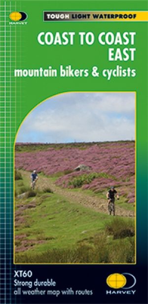
Fietskaart Coast to Coast East England - Harvey maps • 9781851375325
Fietskaart Coast to Coast East England - Harvey maps Productomschrijving: De route van kust tot kust, is bedekt met twee kaarten. De doortocht van kust naar kust is ongeveer 200 mijl. Er is geen één definitieve route. Deze kaarten suggereren twee belangrijkste alternatieven, St Bees naar Robin Hoods Bay (bedacht door Tim Woodcock of Bicester aan Wykeham bedacht door pedaal Noord. De XT60 n…

Lake District Outdoor Adventures with Children - Cicerone • 9781852849566
Wandelgids - Lake District Outdoor Adventures with Children - Cicerone Productomschrijving: 40 Outdoor avonturen in het Lake District met kinderen onder de 12 jaar, inclusief wandelen, fietsen, klauteren, varen, zwemmen, peddelen, kamperen & hostelling. De avonturen worden beoordeeld, met de alternatieven gegeven waar ze bestaan, zodat gezinnen kunnen beginnen aan het avontuur dat het best…

Wandelgids Classic Day Walks in the Peak District - Vertebrate • 9781906148492
Classic Day Walks in the Peak District - Vertebrate Productomschrijving: Day Walks in the Peak District – 20 classic circular routes features 20 circular walks, between 8.1 and 12.1 miles (13km and 19.5km), suitable for hillwalkers of all abilities. Local authors Norman Taylor and Barry Pope share walks in their favourite areas of the Peak District National Park including Chatsworth, Chee …

Wandelkaart 340 Holy Island & Bamburgh - OSI • 9780319475768
Wandelkaart Holy Island & Bamburgh - Explorer Active Productomschrijving: Holy Island en Bamburgh zijn 2 aan de kust liggende eilanden/archipel die de interesse trekt van velen in het teken van natuur bezoek, wandelen of fietsen. De locatie is zeer mooi wat de natuur betreft. Omvat: Cheswick, Ancroft, Haggerston, Bowsden, Beal, Fenwick, Holy Island, Holburn, Doddington, Belford, Waren …

Wandelgids Day Walks in the Yorkshire Dales NP - Vertebrateg Publ • 9781906148225
Day Walks in the Yorkshire Dales NP - Vertebrateg Productomschrijving: 20 circular routes in the Central Pennines Day Walks in the Yorkshire Dales NP is the fourth title in Vertebrate Publishing’s series of compact and portable hillwalking guidebooks. This book showcases 20 circular walks in the Yorkshire Dales National Park, between 6 and 11 miles (10 and 17 kilometres) in length, su…