

Wandelgids Klimgids Munros Peak Bagging Vol 1. Vertebrate Publ.
Munro bagging in Schotland - 64 routes designed to complete all
Korte omschrijving
Wandelgidsen Highlands, Schotland van Vertebrate Publishing. Ideaal voor tochten in Schotland.
Wandelgids & Klimgids Munros Peak Bagging Vol 1. Productomschrijving: Peak Bagging Munros Volume 1 - Our list of munro's Highlands & the southern Cairngorms: 64 routes designed to comp...

Specificaties
- Uitgever: Vertebrate Publishing
- ISBN-13: 9781839812583
- HOOFDCATEGORIEËN: Wandelgids
- Activiteiten: Munro Bagging in Schotland, Wandelen, Hiking & Trekking
- Auteur: Nicola Hardy
- Regio: Highlands, Schotland
- Land: Schotland
- Nationale parken: Cairngorms NP, Schotland
- Editie: 1
- Taal: Engels
- Klimmen: Rotsklimmen
Volledige omschrijving
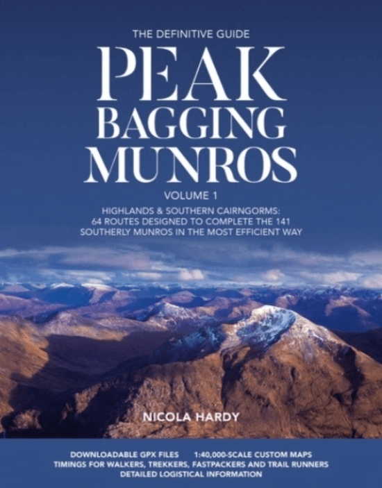
Wandelgids & Klimgids Munros Peak Bagging Vol 1.
Productomschrijving: Peak Bagging Munros Volume 1 - Our list of munro's
Highlands & the southern Cairngorms: 64 routes designed to complete the 141 southerly Munros in the most efficient way.
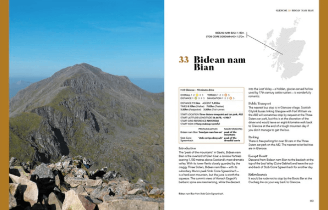
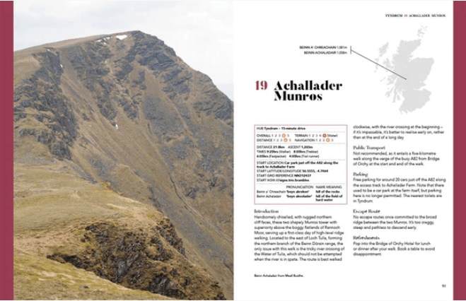
Peak Bagging Munros Volume 1 by Nicola Hardy (Munroist number 6,765) features 64 routes designed to link up the 141 most southerly Munros so you can enjoy the challenge of ‘compleating’ them at your own pace – over years, months or, in rare cases, even just a few weeks. It presents not only the most efficient routes, but does so in such a way that each route is a fantastic walk or run in its own right. The featured routes include the iconic Ring of Steall and Ben Nevis via the Carn Mòr Dearg Arête, alongside classic entry-level walks up the likes of Ben Chonzie, Ben Lomond in Loch Lomond and the Trossachs and Mount Keen in the Cairngorms.
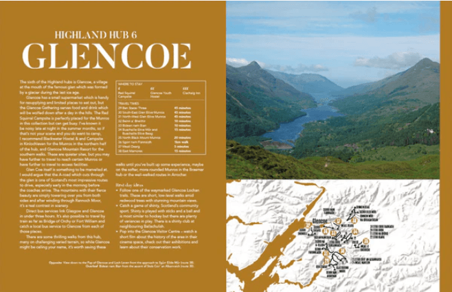
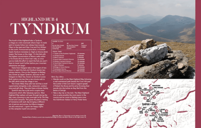
To assist you in building an itinerary, the routes are split into ten Highland hubs which include Glencoe, Fort William, Braemar and Pitlochry. These are chosen to be easy to access and with decent public transport links to help you make environmentally sustainable choices when you can. Base yourself in a Highland hub for a long weekend or a lengthier stay, springboard to Munro routes from each hub and return to access the recommended local facilities including shops, pubs and cafes.
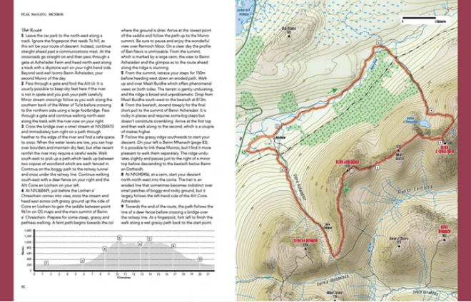
In addition, the book is packed with useful information, including 1:40,000 scale maps, elevation profiles, route directions, public transport and parking details, refreshments, downloadable GPX files for each route, and custom timings for walkers, trekkers, fastpackers and runners. Along with stunning photography, there are rest day suggestions, accommodation ideas to suit multiple budgets and a series of supportive indices through which you can find suitable walks, whatever your current level of hillwalking experience.
Artikelen uit dezelfde regio
Wandelkaart 383 Morvern & Lochaline- Highland's - OSI • 9780319246290
Wandelkaart Morvern & Lochaline - Highland's Schotland Omvat ook: Kingairloch Productomschrijving: Kaart nummer 383 in de OS Explorer kaarten reeks omvat Morvern en Lochaline in de Schotse Hooglanden. Dit schilderachtige gebied beschikt over vele Lochs om te verkennen, met inbegrip van Loch Linnhe, Loch Aline en Loch Sunart samen met de Sound of Mull. De steden Kingairloch en Lochaline…

Wandelkaart 449 Strath Halladale & Strathy Point - OSI • 9780319473016
Wandelkaart Strath Halladale & Strathy Point - Schotland Omvat ook: Melvich & Forsinard. Productbeschrijving: Aan de Noord kust van Schotland, volgt OS Explorer kaart 449 de Strath Halladale en de Halladale-rivier, en omvat Strathy Point, Melvich en Forsinard. Er zijn talrijke kleine lochs aanwezig, evenals de pieken van Beinn Ratha (242 m) en Channian Hil (302 m). De OS Explorer kaart…

Wandelkaart 440 Glen Cassley & Glen Oykel- Schotland - OSI • 9780319472927
Wandelkaart Glen Cassley & Glen Oykel - Highland's Schotland Productbeschrijving: Deze OSi kaart 440, toont de centrale hooglanden, OS Explorer kaart 440 omvat de streek rond Oykel Bridge en Loch Shin. De OS Explorer kaart voor Glen Cassley & Glen Oykel is beschikbaar in zowel de standaard papieren versie als de weerbestendige 'Actief' versie. Productdiscription: This OSi map 440, Show…
Wandelgids The Great Glen Way - Trailblazer • 9781912716104
The Great Glen Way - Trailblazer Publications Productomschrijving: The Great Glen Wayfrom Fort William to Inverness. Het langeafstandswandelpad Great Glen Way begint waar de West Highland Way eindigt - in Fort William - en volgt de breuklijn van de Great Glen om na 79 mijl (127 km) te eindigen in Inverness. Het pad loopt langs Loch Lochy, Loch Oich en Loch Ness en volgt ook het jaagpad van…
Wandelkaart 439 Summer Isles & Coigach- Schotland - OSI • 9780319246825
Wandelkaart Summer Isles & Coigach - Highlands Schotland Productbeschrijving: Inverpolly 439 / Summer Isles, Highlands, Schotland - OS Explorer kaart 439 toont de nationale Scenic Area op het schiereiland Coigach plus de zomer eilanden.Dit gebied zal elke outdoor liefhebber een uitdaging geven. Het gebied is afgelegen, bergachtige en dunbevolkt. De meeste van de zomer-eilanden, met uit…