

Wandelgids Great Mountain Days in the Pennines - Cicerone
Gesorteerde routes die de Walliser fells en veenland dekken


Korte omschrijving
Wandelgidsen North & North East England, North Yorkshire, Engeland en Cumbria, England van CICERONE Press. Ideaal voor tochten in England.
Wandelgids - Great Mountain Days in the Pennines - Cicerone Productomschrijving: Een inspirerende gids naar 50 klassieke wandelingen op het glooiende landschap van de Walliser. De gesorteerd...

Specificaties
- Uitgever: CICERONE Press
- ISBN-13: 9781852846503
- HOOFDCATEGORIEËN: Wandelgids
- Activiteiten: Wandelen, Hiking & Trekking
- Auteur: Terry Marsch
- Regio: Cumbria, England, North & North East England, North Yorkshire, Engeland
- Land: England
- Editie: 1
- Taal: Engels
Volledige omschrijving
Wandelgids - Great Mountain Days in the Pennines - Cicerone
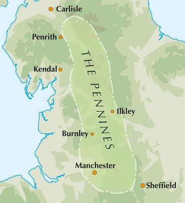
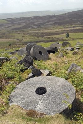
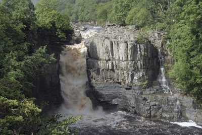
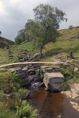
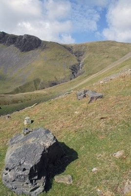
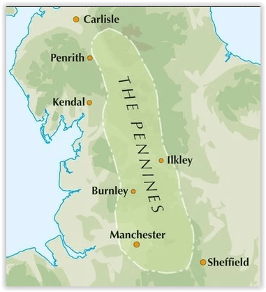
Productomschrijving: Een inspirerende gids naar 50 klassieke wandelingen op het glooiende landschap van de Walliser. De gesorteerde routes, tussen 6 en 13 mijl in lengte, dekken de klassieke Walliser fells en veenland zoals Whernside, Ilkley Moor en Pendle Hill; verkennen van Noord- en Zuid-Pennines, Yorkshire Dales, Howgills en Dark Peak. Veel routes zijn ook geschikt voor lopers. Een inspirerende gids naar 50 gedenkwaardige expedities in de Pennines, de iconische ruggengraat van Engeland. De exacte oppervlakte van de Pennines is moeilijk te definiëren.
Detail: In termen van dit boek breiden ze niet verder uit naar het zuiden van "Mam Tor" boven Edale, en niet veel verder noordelijk dan Cross Fell, de hoogste top van de Pennines, liggend op de oostelijke rand van Cumbria. Binnen dit gebied is een verbazingwekkende, en vaak frustrerende, opeenvolging van landschappen gevormd van riviervalleien, moorlands en hooggelegen Venen.
Product description: An inspirational guidebook to 50 classic walks on the rolling Pennine landscape. The graded routes, between 6 and 13 miles in length, cover classic Pennine fells and moorland such as Whernside, Ilkley Moor and Pendle Hill; exploring the North and South Pennines, Yorkshire Dales, Howgills and Dark Peak. Many routes are also suited to fell running.
Seasons:
The Pennines can be tackled whatever the time of year, although the highest summits and the remote moors can be problematic in winter conditions or poor visibility.
Centres:
Walks are grouped into five areas: the North Pennines, the Howgills, the Yorkshire Dales, the South Pennines and the Dark Peak.
Difficulty:
Walks are graded from 'Moderate' to 'Strenuous' but unlike other mountainous areas where the ability to cope on rock and steep slopes is required, among the Pennines there also needs to be awareness of the deceptive nature of the landscapes, which, in spite of relative proximity to towns and cities, often feel remarkably remote; a sure grasp on navigational skills and self-protection is essential at all times.
Must See:
From the highest summits of the Pennines, to the seductive valleys of the Yorkshire Dales and the rugged landscapes of the South Pennines, this guide embraces all that is inspiring about the rolling Pennine landscapes.
Locatie op kaart
Artikelen uit dezelfde regio

Wandelgids Guide to the Lake District - AA • 9780749579432
Wandelgids - Guide to the Lake District - AA Productomschrijving: Cumbria op zich werd al eens enkel gelend voor de Lake District, maar is uiteraard veel meer dan dat. Veel van de regio houd wel degelijk deze prachitge plaats in. Een nationaal park van formaat, die geen enkel natuurliefhebber onontroerd laat. The Lake District national park, is een plaat uit de duizend in Engeland, alhoewe…

Wandelkaart Coast to Coast (west) St Bees to Keld - Harvey maps • 978185137618
Wandelkaart Coast to Coast (west) St Bees to Keld - Harvey maps Productomschrijving: Toont de gehele westelijke helft van de route op één deel van de kaart. Heeft betrekking op het gedeelte van St Bees naar Keld. Omvat alle alternatieve routes. Gedetailleerde kaart met aanvullende informatie en handige telefoonnummers, schaal van 1: 40.000. Nieuwe generatie HARVEY Superwalker, XT25 wat…

Wandelgids Hadrian's Wall Path - Rucksack Readers • 9781913817312
Wandelgids Hadrian's Wall Path Productomschrijving: Hadrian's Wall Path runs for 86 miles (135 km) between Bowness-on-Solway and Wallsend (Newcastle) along the line of the Roman Wall completed in AD122 under the Emperor Hadrian. This National Trail crosses northern England from Irish Sea to North Sea and offers many chances to look at the forts, milecastles and interpretation centres withi…

Wandelkaart 297 Lower Wharfedale & Washburn Valley - OSI • 9780319245491
Wandelkaart Lower Wharfedale & Washburn Valley - North Yorkshire Omvat ook: Harrogate & Ilkley Moor Productomschrijving: Kaart nummer 297 in de OS Explorer kaarten reeks heeft betrekking op het Nidderdale AONB en het Yorkshire Dales National Park. De stad van Harrogate is omgeven door het Harrogate Ringway recreatief pad, terwijl de Dales Way loopt langs Ilkley, Otley en Guisely. Ander…
Fietsgids Hadrian's Cycleway - Cicerone • 9781786310422
Fietsgids - Hadrian's Cycleway - Cicerone Productomschrijving: Hadrian's Cycleway, een dikke 250 km lange kust tot kust fietsroute over noordelijk Engeland, die de route volgt voor zover mogelijk natuurlijk, langs de bekende Hadrian's Wall World Heritage Site. Deze route loopt van Ravenglass in Cumbria doorheen Northumberland to South Shields aan de oostkust van Engeland, met een eventuele…