
Mountainbike kaart Peak District National Park - Goldeneye
Dark Peak - White Peak - Derbyshire Dales
Korte omschrijving
Fietskaarten Derbyshire & Peak District, England van Goldeneye. Ideaal voor tochten in England.
MTB-kaart Peak District National Park - Goldeneye Productomschrijving: The Peak District National Park is a remarkable place - from the north, the upturned horseshoe of high, gritstone moor...

Specificaties
- Uitgever: Goldeneye
- ISBN-13: 9781859653012
- HOOFDCATEGORIEËN: Fietskaart
- Activiteiten: Fietsen / VTT / MTB
- Regio: Derbyshire & Peak District, England
- Land: England
- Nationale parken: Peak District NP, Derbyshire UK
- TOPO's & Stafkaarten: Topografisch - fietsen
- Schaal: 1:37700
- Editie: 5
- Taal: Engels
- De Nationale Parken: Peak District Nationaal Park, England
- De Engelse Graafschappen: Derbyshire, South Yorkshire
- VTT / MTB: Mountainbike
Volledige omschrijving
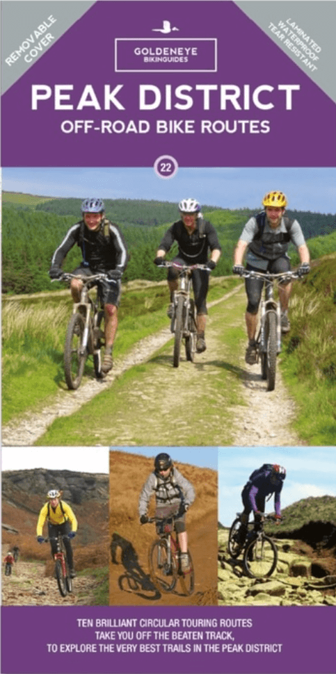
MTB-kaart Peak District National Park - Goldeneye
Productomschrijving: The Peak District National Park is a remarkable place - from the north, the upturned horseshoe of high, gritstone moors and crags of the Dark Peak extend southwards to the east and west of the contrasting limestone plateau of the softer pastoral landscape of the White Peak itself incised by the valleys of the Derbyshire Dales.
These differing landscapes offer some of the best off-road biking in Britain, from difficult, loose surfaced climbs and gnarly, rocky descents that test both nerve and technical skill, to ancient pack-horse trails, long grassy drovers' roads and converted railway tracks.
The routes are graded: easy, moderate and more strenuous. Approximate times and mileage are included.
The routes include:
1. Edale - Hayfield Circuit.
2. Hope - Jaggers Clough Circuit.
3. Castleton - Rushup Edge.
4. Ladybower South Circuit.
5. Strines & Ughill Moors Circuit.
6. Stanage Circuit.
7. Eyam - Stoney Middleton - Coombs Lane - Tideswell Lane Circuit.
8. Bakewell Circuit.
9. Parsley Hay - Middleton - Long Dale - Pikehall Circuit.
10. Winster Circuit.
Artikelen uit dezelfde regio

Fietskaart 03 Peak District cycling map - Goldeneye • 9781859653043
Fietskaart Peak District cycling map - Goldeneye Productomschrijving: Het Peak District is een nationaal park van formaat pal in het centrum van Engeland. deze kaart biedt u een overzicht van alle fietsroutes in- en door het park. Het Peak District is dan ook goed gekend voor zijn heuvel, bergen, waterwegen, wandel- en fietsroutes. Egelse omschrijving: The Peak District offers some of …

Wandelkaart OL01 Peak District NP & Dark Peak area - OS • 9780319263655
Wandelkaart Peak District NP & Dark Peak area - OS Productomschrijving: Peak District National Park & Dark Peak area, Derbyshire England. Omvat: Parts of Peak districh National & Dark peak Area, Kinder Scout, Bleaklow, Black Hill & Ladybower Reservoir. Ontdek de OL-serie van Ordnance Survey: De OL-serie (Outdoor Leisure) van Ordnance Survey is dé referentie voor wie gaat wandele…

Wandelgids Peak District-Bakewell & The White Peak - Cicerone • 9781786312570
Wandelgids Peak District-Bakewell & The White Peak - Cicerone Productomschrijving: Would you like to explore the best of Bakewell and the White Peak? This guidebook covers 15 of the best short walks in the Peak District (between 4 and 10km, all under three hours), including Taddington, Chatsworth Park, Sheldon and Magpie Mine, Elton and Robin Hood's Stride, and the Monsal Trail. Why c…

Wandelkaart OL24 Peak District & White Peak area - OS • 9780319263846
Wandelkaart Peak District & White Peak area - OS Productomschrijving: Peak District & White Peak area, Derbyshire England Omvat: Buxton, Bakewell, Matlock & Dove Dale, with parts of the Peak district National Park. Ontdek de OL-serie van Ordnance Survey: De OL-serie (Outdoor Leisure) van Ordnance Survey is dé referentie voor wie gaat wandelen op de Britse eilanden. Deze topograf…
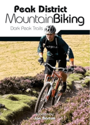
Mountainbikegids Peak District Mountain Biking - Vertebrate Publ. • 9781906148188
Peak District Mountain Biking - Vertebrate Productomschrijving: Peak District Mountain Biking by Jon Barton features 26 of the best mountain bike rides in the Dark Peak, between 9km and 105km in length, suitable for all levels of mountain bikers. This second edition features Ordnance Survey maps, and is illustrated with action photography. Includes Grenoside Woods and Lady Canning's Planta…