

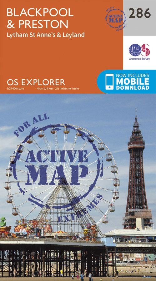
Wandelkaart 286 Blackpool & Preston- Lancashire - OSI
Van Blackpool en Preston langs de kust naar het binnenland


Korte omschrijving
Wandelkaarten Lanacshire, England van Ordnance Survey. Ideaal voor tochten in England.
Wandelkaart Blackpool & Preston - Lancashire England Omvat ook: Lytham St Anne’s & Leylan Productomschrijving: Van Blackpool en Preston langs de kust naar het binnenland van Preston en L...

Specificaties
- Uitgever: Ordnance Survey
- ISBN-13: 9780319471586
- HOOFDCATEGORIEËN: Wandelkaart
- Activiteiten: Wandelen, Hiking & Trekking
- Regio: Lanacshire, England
- Land: England
- Waterafstotende kaart: Ordnance Survey ACTIVE Explorer Weatherproof Maps
- TOPO's & Stafkaarten: Topografisch wandelen
- Schaal: 1:25000
- Taal: Engels
- Reeks/Serie: Explorer ACTIVE Series OSI
- De Engelse Graafschappen: Lancashire
Volledige omschrijving
Wandelkaart Blackpool & Preston - Lancashire England
Omvat ook: Lytham St Anne’s & Leylan
Productomschrijving: Van Blackpool en Preston langs de kust naar het binnenland van Preston en Leyland. Deze OS Explorer kaart 286 toont de zuidkant van de kust van Lancashire, vanaf Freckleton, tot het westelijke deel van de Ribble way. Het gebied is grotendeels vlak, waardoor dit een geweldige locatie is voor fietsers - de Flyde kust roundway maakt gebruik van de beroemde Promenade van Blackpool.
Kaart nummer 286 is een all purpose kaart vol gepakt met informatie om u het gebied te helpen leren kennen. De kaarten bestrijken het land. Elke kaart heeft een oppervlakte van 40 km door 40 km (25 mijl door 25 mijl) en zoals andere kaarten van Ordnance Survey, National Grid-vierkanten worden verstrekt zodat elke functie een unieke referentienummer kan worden gegeven.
Productdiscription: From Blackpool and Preston on the coast to Preston and Leyland inland, OS Explorer Map 286 shows the southern end of the Lancashire Coastal Way, starting at Freckleton, and the western end of the Ribble Way. The area is largely flat, making this a great location for cyclists - the Flyde Coast Circular route uses the famous Blackpool Promenade.The OS Explorer map for Blackpool & Preston is available in both the standard paper version and weatherproof 'Active' version.
Locatie op kaart
Artikelen uit dezelfde regio

Wandelkaart OL41 - Forest of Bowland & Ribblesdale - OSI • 9780319469590
Wandelkaart Forest of Bowland & Ribblesdale - North Yorkshire Omvat ook: Pendle Hill, Clitheroe & Settle Productbeschrijving: Kaart nummer OL41 in de OS Explorer kaarten reeks omvat de Forest of Bowland en Yorkshire Dales National Park in de buurt van Clitheroe. Hoogtepunten van het gebied zijn onder andere: Ribble way & Wyre way, Lune Valley walkway en Pendle way, samen met de steden …
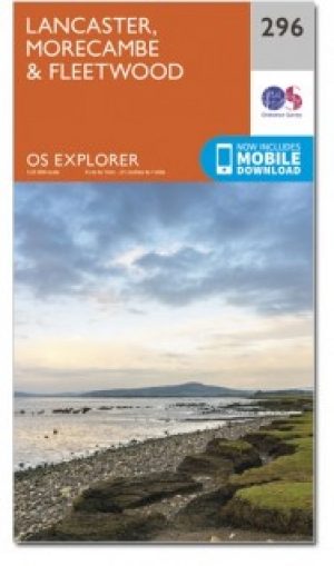
Wandelkaart 296 Lancaster- Morecambe & Fleetwood - OSI • 9780319471685
Wandelkaart Lancaster- Morecambe & Fleetwood - Lancaster Productbeschrijving: Kaart nummer 296 dekt Lancaster, Morecambe en Fleetwood. Hoogtepunten zijn Heysham, Lancaster Castle en Knott End-on-Sea. Omvat ook Overton en Middleton. De OS Explorer kaart voor Lancaster, Morecambe & Fleetwood is beschikbaar in zowel de standaard papieren versie als de weerbestendige 'Actief' versie. Produ…

Wandelgids 015 Pathfinder guides Yorkshire Dales NP - OS • 9780319090404
Wandelgids Yorkshire Dales NP - OS Productomschrijving: Pathfinder Yorkshire Dales covering parts of the National Park, Ribblesdale and Swaledale. This selection offers interest, regional variety and balance of routes in the Yorkshire Dales providing the best walks in the area. From an easy stroll through Ingleton Waterfalls to the much more challenging walks in Gunnerside, this volume co…

Wandelkaart OL41 Forest of Bowland & Ribblesdale - OS • 9780319242803
Wandelkaart Forest of Bowland AONB & Ribblesdale - OS Productomschrijving: Pendle Hill- Clitheroe & Settle - Yorkshire Dales NP, A pennine Journey, Dales High Way, Lancashire Coastal Way, Line Valley Ramble, Pendle Way, Pennine bridleway, Ribble Way & Wyre Way. Omvat: Pendle Hill- Clitheroe & Settle - parts of the Yorkshire Dales NP, Ontdek de OL-serie van Ordnance Survey: De O…

Wandelgids King Charles III England Coast Path - Cicerone • 9781786310279
King Charles III England Coast Path - Cicerone Productomschrijving: A guidebook to walking the northwest section of the King Charles III England Coast Path between Gretna and Chester. Covering 590km (367 miles), this straightforward trail along the Cumbria, Lancashire and Merseyside coast takes around 1 month to hike. The route is described from north to south in 28 stages between 13 a…