

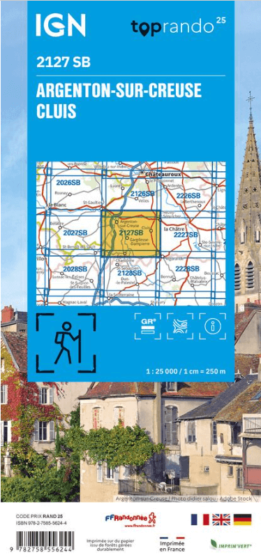
Wandelkaart 2127 SB Argenton-sur-Creuse & Cluis - IGN
Gournay- Mouhers- La Buxerette- Mosnay- Bouesse- Malicornay...

Korte omschrijving
Wandelkaarten Centre Val de Loire, Frankrijk van Institut Géographique National. Ideaal voor tochten in Frankrijk.
Wandelkaart Argenton-sur-Creuse & Cluis - IGN Productomschrijving: Argenton-sur-Creuse & Cluis zijn beide te vinden in het Franse departement Indre, gelegen in de regio van Centre-vla-de-Loi...

Specificaties
- Uitgever: Institut Géographique National
- ISBN-13: 9782758556244
- HOOFDCATEGORIEËN: Wandelkaart
- Activiteiten: Wandelen, Hiking & Trekking
- Regio: Centre Val de Loire, Frankrijk
- Land: Frankrijk
- Departement: Indre (36)
- Schaal: 1:25000
- Editie: 2
- Taal: Frans
- Reeks/Serie: IGN France > TOP25 Randoo / Série Bleue
- De Franse Regio's: Centre-val-de-Loire
Volledige omschrijving
Wandelkaart Argenton-sur-Creuse & Cluis - IGN
Productomschrijving: Argenton-sur-Creuse & Cluis zijn beide te vinden in het Franse departement Indre, gelegen in de regio van Centre-vla-de-Loire.
Franse omschrijving van de uitgever: L'indispensable carte de randonnée IGN 2127SB. D'une très grande précision elle contient tous les détails existants sur le terrain : voies de communication jusqu'au moindre sentier, constructions jusqu'au hangar, bois, arbre isolé, rivière, source... Sans oublier la représentation du relief par des courbes de niveau. Les sentiers balisés et les informations touristiques sont également représentées.
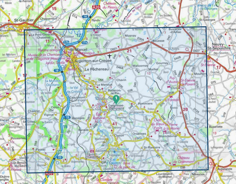
Omvat: Argenton-sur-Creuse, Cluis, Gournay, Mouhers, La Buxerette, Mosnay, Bouesse, Malicornay, Le Pêchereau, Saint-Plantaire, Maillet, Vigoux, Pommiers, Celon, Chavin, Chazelet, Bazaiges, Ceaulmont, Le Menoux, Badecon-le-Pin, Le Pont-Chrétien-Chabenet, Saint-Marcel, Thenay.
Te ontdekken: Parc Naturel de la Brenne,Lac d'Eguzon,Barage d'Éguzon, Château de Breuil-Yvain, Château du Courbas, Château de Châteaubrun,Château de la Prune au Pot, Château de la Rocherolle, Château du Châtellier, St-Benoît.
Afmetingen: 96 cm x 121 cm
Overzichtskaarten

IGN TOP25 Wandelkaarten Dordogne - Limousin
IGN TOP25 Wandelkaarten Dordogne - Limousin

Producten op de overzichtskaart
Klik op een product om naar de detailpagina te gaan.
- Wandelkaart 1828 SB Gençay & Persac - IGN
- Wandelkaart 1829 SB L'Isle-Jourdain & Charroux - IGN
- Wandelkaart 1830 SB Confolens & Mouton - IGN
- Wandelkaart 1831 SB Rochefoucauld & Exideuil - IGN
- Wandelkaart 1832 SB Montbron- Piégut & Pluviers - IGN
- Wandelkaart 1927 SB La Trimouille & St-Savin - IGN
- Wandelkaart 1928 SB Montmorillon & Lathus-St-Rémy - IGN
- Wandelkaart 1929 SB Bellac & Adriers - IGN
- Wandelkaart 1930 SB Oradour-sur-Glane & Brigueuil - IGN
- Wandelkaart 1931 SB Rochechouart & St-Junien - IGN
- Wandelkaart 1932 SB Châlus & St-Mathieu - IGN
- Wandelkaart 2028 SB St-Sulpice-les-Feuilles - IGN
- Wandelkaart 2029 SB Bessines-sur-Gartempe & Magnac-Laval - IGN
- Wandelkaart 2030 SB Ambazac & Nantiat - IGN
- Wandelkaart 2031 SB Limoges - IGN
- Wandelkaart 2032 SB Pierre-Buffière & Nexon - IGN
- Wandelkaart 2127 SB Argenton-sur-Creuse & Cluis - IGN
- Wandelkaart 2128 SB Dun-le-Palestel & St-Sébastien - IGN
- Wandelkaart 2129 SB La Souterraine & St-Vaury - IGN
- Wandelkaart 2131 SB St-Léonard-de-Noblat & Eymoutiers - IGN
- Wandelkaart 2132 SB Châteauneuf-la-Forêt & Chamberet - IGN
- Wandelkaart 2227 SB La Châtre & Neuvy-St-Sépulchre - IGN
- Wandelkaart 2228 SB Aigurande & Châtelus-Malvaleix - IGN
- Wandelkaart 2229 SB Guéret & Ahun - IGN
- Wandelkaart 2230 SB Lavaveix-les-Mines & Pontarion - IGN
- Wandelkaart 2231 SB Royère-de-Vassivière - IGN
- Wandelkaart 2232 SB Bugeat & Peyrelevade - IGN
Artikelen uit dezelfde regio

Wandelkaart 2831 SB Feurs & Boën Rhone-Alpes - IGN • 9782758535621
Wandelkaart - Feurs & Boën Rhone-Alpes Omvat: Feurs is een gemeente in het Franse departement Loire (regio Rhône-Alpes) De plaats maakt deel uit van het arrondissement Montbrison. In de gemeente ligt spoorwegstation Feurs. Productomschrijving: Tussen 2014 en 2018 vernieuwt IGN haar volledige collectie serie blauw. Een nieuwe toewijzing voor optimale leesbaarheid, met een grotere mate …
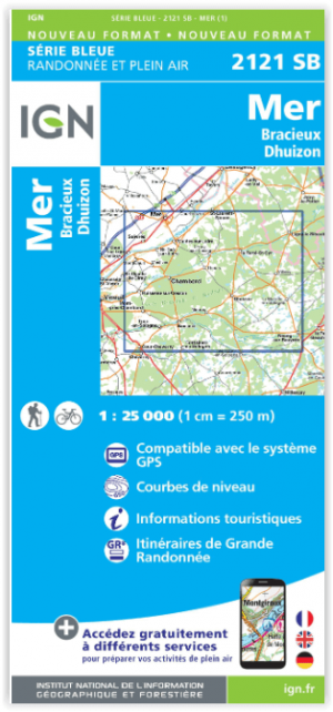
Wandelkaart 2121 SB Mer - Bracieux - Dhuizon - IGN • 9782758539193
Wandelkaart Mer - Bracieux - Dhuizon - IGN Productomschrijving: Bracieux & Dhuizon zijn gemeentes in het Franse departement Loir-et-Cher, in de regio Centre-Val de Loire. De plaats maakt deel uit van het arrondissement Blois en liggen tussen de wereldberoemde kastelen van Chambord en Cheverny. De TOP 25 kaarten (kaart nummers die eindigen op SB) zicht de nieuwe reeks van IGN, en bestaa…

Wandelkaart 2220 SB Olivet- La Ferté-St-Aubin & Jargeau - IGN • 9782758548461
Wandelkaart 2220 SB - Olivet- La Ferté-St-Aubin & Jargeau Productomschrijving: Olivet- La Ferté-St-Aubin & Jargeau zijn gemeentes in het Franse departement Loiret in de regio Centre-Val de Loire. De plaats maakt deel uit van het arrondissement Orléans. Tussen 2014 en 2020 vernieuwt IGN haar volledige collectie serie blauw. Een nieuwe toewijzing voor optimale leesbaarheid, met een grote…

Wandelkaart 1917 SB Nogent-le-Rotrou & Thiron-Gardais - IGN • 9782758533160
Wandelkaart 1917 SB - Nogent-le-Rotrou & Thiron-Gardais Productomschrijving: Deze topografische kaarten hebben een zeer nauwkeurige gronddetail, niet te vergeten de topografische hoogteprofielen, die het wandelen een stuk gemakkelijker maken. Nogent-le-Rotrou is een gemeente in het Franse departement Eure-et-Loir (regio Centre) en telt 11.524 inwoners. De plaats maakt deel uit van het arr…

Wandelkaart 2325 SB Châteuneuf-sur-Cher & Levet - IGN • 9782758534204
Wandelkaart 2325 SB - Châteuneuf-sur-Cher & Levet Productomschrijving: Deze topografische kaarten hebben een zeer nauwkeurige gronddetail, niet te vergeten de topografische hoogteprofielen, die het wandelen een stuk gemakkelijker maken. Châteauneuf-sur-Cher is een gemeente in het Franse departement Cher (regio Centre) en telt 1614 inwoners (1999). De plaats maakt deel uit van het arrondiss…