

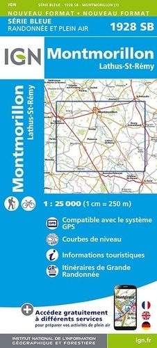
Wandelkaart 1928 SB Montmorillon & Lathus-St-Rémy - IGN
Montmorillon & Lathus-St-Rémy zijn gemeentes in het Franse Vienne

Korte omschrijving
Wandelkaarten Nouvelle-Aquitaine, Frankrijk van Institut Géographique National. Ideaal voor tochten in Frankrijk.
Wandelkaart 1928 SB - Montmorillon & Lathus-St-Rémy Productomschrijving: Montmorillon & Lathus-St-Rémy zijn gemeentes in het Franse departement Vienne in de regio Nouvelle-Aquitaine. De plaa...

Specificaties
- Uitgever: Institut Géographique National
- ISBN-13: 9782758544944
- HOOFDCATEGORIEËN: Wandelkaart
- Activiteiten: Wandelen, Hiking & Trekking
- Regio: Nouvelle-Aquitaine, Frankrijk
- Land: Frankrijk
- Departement: Vienne (86)
- Schaal: 1:25000
- Editie: 1
- Taal: Frans
- Reeks/Serie: IGN France > TOP25 Randoo / Série Bleue
Volledige omschrijving
Wandelkaart 1928 SB - Montmorillon & Lathus-St-Rémy
Productomschrijving: Montmorillon & Lathus-St-Rémy zijn gemeentes in het Franse departement Vienne in de regio Nouvelle-Aquitaine. De plaats maakt deel uit van het arrondissement Montmorillon. De locatie is gekend voor zijn rust en vele wandel mogelijkheden in een mooie omgeving. Een kaart voor wie de rust opzoekt.
Locatie op kaart
Overzichtskaarten

IGN TOP25 Wandelkaarten Dordogne - Limousin
IGN TOP25 Wandelkaarten Dordogne - Limousin

Producten op de overzichtskaart
Klik op een product om naar de detailpagina te gaan.
- Wandelkaart 1828 SB Gençay & Persac - IGN
- Wandelkaart 1829 SB L'Isle-Jourdain & Charroux - IGN
- Wandelkaart 1830 SB Confolens & Mouton - IGN
- Wandelkaart 1831 SB Rochefoucauld & Exideuil - IGN
- Wandelkaart 1832 SB Montbron- Piégut & Pluviers - IGN
- Wandelkaart 1927 SB La Trimouille & St-Savin - IGN
- Wandelkaart 1928 SB Montmorillon & Lathus-St-Rémy - IGN
- Wandelkaart 1929 SB Bellac & Adriers - IGN
- Wandelkaart 1930 SB Oradour-sur-Glane & Brigueuil - IGN
- Wandelkaart 1931 SB Rochechouart & St-Junien - IGN
- Wandelkaart 1932 SB Châlus & St-Mathieu - IGN
- Wandelkaart 2028 SB St-Sulpice-les-Feuilles - IGN
- Wandelkaart 2029 SB Bessines-sur-Gartempe & Magnac-Laval - IGN
- Wandelkaart 2030 SB Ambazac & Nantiat - IGN
- Wandelkaart 2031 SB Limoges - IGN
- Wandelkaart 2032 SB Pierre-Buffière & Nexon - IGN
- Wandelkaart 2127 SB Argenton-sur-Creuse & Cluis - IGN
- Wandelkaart 2128 SB Dun-le-Palestel & St-Sébastien - IGN
- Wandelkaart 2129 SB La Souterraine & St-Vaury - IGN
- Wandelkaart 2131 SB St-Léonard-de-Noblat & Eymoutiers - IGN
- Wandelkaart 2132 SB Châteauneuf-la-Forêt & Chamberet - IGN
- Wandelkaart 2227 SB La Châtre & Neuvy-St-Sépulchre - IGN
- Wandelkaart 2228 SB Aigurande & Châtelus-Malvaleix - IGN
- Wandelkaart 2229 SB Guéret & Ahun - IGN
- Wandelkaart 2230 SB Lavaveix-les-Mines & Pontarion - IGN
- Wandelkaart 2231 SB Royère-de-Vassivière - IGN
- Wandelkaart 2232 SB Bugeat & Peyrelevade - IGN
Artikelen uit dezelfde regio

Wandelkaart 1934 SB Périgueux & Excideuil - IGN • 9782758548225
Wandelkaart 1934 SB - Périgueux & Excideuil Productomschrijving: Périgueux & Excideuil zijn gemeentes in het Franse departement Dordogne in de regio Nouvelle-Aquitaine. De plaats maakt deel uit van het arrondissement Périgueux. Tussen 2014 en 2020 vernieuwt IGN haar volledige collectie serie blauw. Een nieuwe toewijzing voor optimale leesbaarheid, met een grotere mate van geometrische …

Wandelkaart 1936 ET Les Eyzies-de-Tayac-Sireuil - IGN • 9782758555865
Wandelkaart Les Eyzies-de-Tayac-Sireuil - IGN Omvat: Tamniès, Valojoulx, Saint-André-d'Allas, Vézac, Saint-Vincent-de-Cosse, Peyzac-le-Moustier, Allas-les-Mines, Siorac-en-Périgord, Saint-Chamassy, Saint-Germain-de-Belvès, Berbiguières, Cladech, Marnac, Mauzens-et-Miremont, Savignac-de-Miremont, Les Eyzies, Sergeac, Saint-Léon-sur-Vézère, Marquay, Beynac-et-Cazenac, Limeuil, Campagne, Sain…

Wandelkaart 2135 SB Brive-la-Gaillarde- Beynat & Meyssac - IGN • 9782758548409
Wandelkaart 2135 SB - Brive-la-Gaillarde- Beynat & Meyssac Productomschrijving: Brive-la-Gaillarde- Beynat & Meyssac zijn gemeentes in het Franse departement Corrèze in de regio Nouvelle-Aquitaine. De plaats maakt deel uit van het arrondissement Brive-la-Gaillarde. Tussen 2014 en 2018 vernieuwt IGN haar volledige collectie serie blauw. Een nieuwe toewijzing voor optimale leesbaarheid, …

Reisgids Het beste van Périgord Frankrijk - Edicola • 9789492920430
Reisgids het beste van de Périgord Paradijselijk - Edicola Productomschrijving: Ça y est, je suis au paradis. Schoonheid, al vanaf de oermens een rijk cultureel en historisch erfgoed in combinatie met unieke culinaire specialiteiten maken de Périgord Vert en zijn natuurpark Périgord-Limousin een fascinerende reisbestemming. In deze reisgids neemt Jet Vedelaar de lezer mee op ontdekkingsrei…

Wandelkaart 1546 OT Oloron-Ste-Marie & Vallée d'Aspe - IGN • 9782758553014
Wandelkaart Oloron-Ste-Marie & Vallée d'Aspe - IGN Productomschrijving: De IGN 1546 OT wandelkaart, is zeer nauwkeurig, bevat alle details die bestaan van verbindingswegen tot op het kleinste pad, gebouwen, bossen, rivieren, bronnen... En niet te vergeten de weergave van het reliëf door contourlijnen. Ook de gemarkeerde paden en toeristische informatie zijn vertegenwoordigd. Franse oms…