

Wandelgids The Big Rounds - Cicerone
De Lake district- Snowdonia & de Cairngorms in Schotland


Korte omschrijving
Wandelgidsen Cumbria & Lake District, England van CICERONE Press. Ideaal voor tochten in England.
Wandelgids - The Big Rounds - Cicerone Productomschrijving: Deze inspirerende gids kijkt naar elk van de 19 nationale routes in het Verenigd Koninkrijk, met informatie die vergelijkings- en ...

Specificaties
- Uitgever: CICERONE Press
- ISBN-13: 9781852847722
- HOOFDCATEGORIEËN: Wandelgids
- Activiteiten: Wandelen, Hiking & Trekking
- Auteur: David Lintern
- Regio: Cumbria & Lake District, England
- Land: England
- Nationale parken: Cairngorms NP, Schotland, Lake District NP, Cumbria England, Snowdonia NP, Wales UK
- Editie: 1
- Taal: Engels
Volledige omschrijving
Wandelgids - The Big Rounds - Cicerone
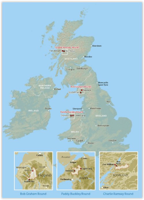
Productomschrijving: Deze inspirerende gids kijkt naar elk van de 19 nationale routes in het Verenigd Koninkrijk, met informatie die vergelijkings- en contrastgemak mogelijk maakt, waardoor u wordt geïnspireerd om meer te weten te komen en een uitdaging op lange afstand aan te gaan. Sommige paden zijn kort en gemakkelijk, anderen veel langer, en veel hebben sterke thema's - ze kunnen een kustlijn volgen of heuvels doorkruisen. Deze gids brengt u in- en rond 3 majestieuze nationale parken in Engeland, Wales & Schotland: De Lake district, Snowdonia in Wales en de Cairngorms in Schotland.
Product description: This inspirational guidebook looks at each of the UK's 19 National Trails, with information that allows ease of comparison and contrast, inspiring you to find out more and to take up a long-distance challenge. Some Trails are short and easy, others much longer, many have strong themes - they may follow a coastline, or traverse ranges of hills.
Seasons:
All trails can be tackled throughout the year, though many of the northern and Scottish routes can be challenging in winter conditions. Avoid the Hadrian's Wall Path in winter, as the ground is soft and underlying archaeology easily damaged.
Difficulty:
The routes vary in both length and technical difficulty, the longest being the South West Coast Path and the most difficult possibly the Pennine Way.
Must See:
Broad views and unspoilt landscapes in some of Britain's best walking areas - from thunderous breaking waves against the cliffs on the South West Coast Path to Buachaille Etive Mor at the gateway to Glen Coe.

Locatie op kaart
Artikelen uit dezelfde regio

Wandelkaart Lake District National Park XT40 - Harvey Maps • 9781851376865
Wandelkaart Lake District XT40 - Harvey Maps Productomschrijving: Een nieuwe generatie kaarten van stevig polyethyleen. Ze zijn stevig, duurzaam en 100% waterdicht, compact en licht om mee te nemen. Deze all weather Britse bergkaart voor klimmers, bergwandelaars, bergbeklimmers en mountainbikers is uitgegeven door HARVEY in samenwerking met de British Mountaineering Council. De beroemd…

Wandelgids King Charles III England Coast Path - Cicerone • 9781786310279
King Charles III England Coast Path - Cicerone Productomschrijving: A guidebook to walking the northwest section of the King Charles III England Coast Path between Gretna and Chester. Covering 590km (367 miles), this straightforward trail along the Cumbria, Lancashire and Merseyside coast takes around 1 month to hike. The route is described from north to south in 28 stages between 13 a…

Wandelgids King Charles III England Coast Path Map Booklet • 9781786310293
Wandelgids King Charles III England Coast Path Map Booklet Productomschrijving: This map booklet to the Cumbrian section of the England Coast Path contains detailed mapping for walking the route in either direction. With easy access at many points along the way, the Cumbrian section can be enjoyed as a trek of around 15 days or in shorter sections. - Full route shown on 1:25,000 OS map…
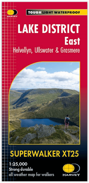
Wandelkaart XT25 Lake District Oost - Harvey Maps • 9781851376438
Wandelkaart Lake District East - Harvey Maps Productomschrijving: Inclusief Helvellyn en High Street en bergen ten oosten van de Kendal-Keswick weg. De Kirkstone Pass, Ullswater, Haweswater en Kentmere staan op dit blad. Gedetailleerde kaart voor bergwandelaars van de oostelijke bergen van het Lake District National Park. - Inclusief 82 bergtoppen beschreven door A.Wainwright. …

Fietsgids Bikepacking in the Lake District - Cicerone • 9781786311177
Bikepacking in the Lake District - Cicerone Productomschrijving: Bikepacking is het off-road equivalent van fietstochten en biedt vaak de mogelijkheid om wild te kamperen naast de gebruikelijke overnachtingsmogelijkheden: het belooft een ongeëvenaarde kans om jezelf onder te dompelen in de omgeving terwijl je het beste van wat het gebied te bieden heeft op twee wielen verkent. Deze gids pr…