

Wandelgids Day Walks in the North York Moors - Vertebrate Publ.
The Cleveland Hills - Hambleton Hills - Central Moors


Korte omschrijving
Wandelgidsen Yorkshire, England van Vertebrate Publishing. Ideaal voor tochten in England.
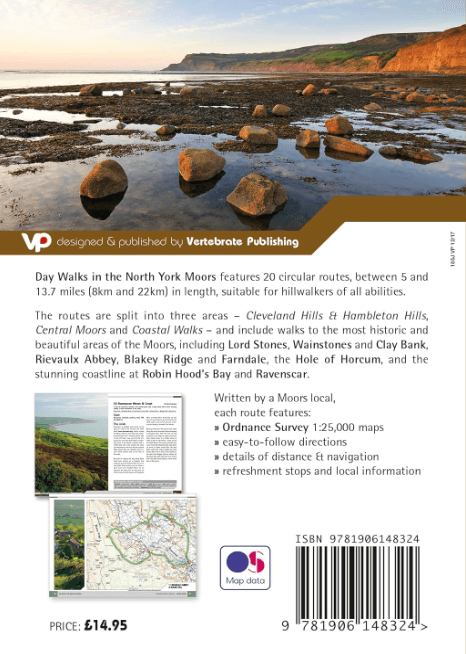
Day Walks in the North York Moors - Vertebrate Productomschrijving: 20 circular routes in North Yorkshire Day Walks on the North York Moors showcases 20 circular walks, between 5 and 13...

Specificaties
- Uitgever: Vertebrate Publishing
- ISBN-13: 9781906148324
- HOOFDCATEGORIEËN: Wandelgids
- Activiteiten: Wandelen, Hiking & Trekking
- Auteur: Tony Harker
- Regio: Yorkshire, England
- Land: England
- Nationale parken: North York Moors NP, England
- Taal: Engels
- Reeks/Serie: Day walks in, vertebrate Publishing
- De Nationale Parken: North Yorkshire Moors National Park, England
- De Engelse Graafschappen: North Yorkshire
Volledige omschrijving
Day Walks in the North York Moors - Vertebrate
Productomschrijving: 20 circular routes in North Yorkshire
Day Walks on the North York Moors showcases 20 circular walks, between 5 and 13.7 miles (8 and 22 kilometres) in length, suitable for hillwalkers of all abilities. The routes are split into three areas – The Cleveland Hills and Hambleton Hills, Central Moors and Coastal Walks – and include walks to the most historic and beautiful areas of the Moors, including: Lord Stones, Wainstones and Clay Bank, Rievaulx Abbey, Blakey Ridge and Farndale, the Hole of Horcum, and the stunning coastline at Robin Hood’s Bay and Ravenscar.
The author of this guidebook, Tony Harker, is a Moors local and keen hillwalker. Each route in this guide is described with easy-to-follow directions and details of distance, navigation information and refreshment stops, and is plotted on clear and easy to use Ordnance Survey 1:25,000 maps. The walks are illustrated with stunning photography by Adam Long. Also included is a detailed Appendix.

Artikelen uit dezelfde regio

Wandelgids 093 Pathfinde North Yorkshire Accessible walks - OS • 9780319092859
Wandelgids North Yorkshire Accessible walks - OS Productomschrijving: This guide comprises 33 beautiful walks, ranging in distance from 0.5 to 8 miles, across North Yorkshire, with ten routes in the Yorkshire Dales National Park, eleven in the North York Moors National Park, North Sea coast routes at Whitby, Robin Hood’s Bay and Bempton, and routes handily placed near the Richmond, Ripon, …
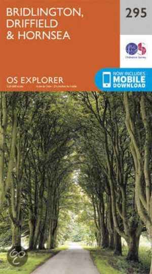
Wandelkaart 295 Bridlington- Driffield & Hornsea - OSI • 9780319245477
Wandelkaart Bridlington- Driffield & Hornsea - Yorkshire Productbeschrijving: 295 / Bridlington, Driffield & Hornsea, East Riding of Yorkshire, England - Van Hornsea langs de kust naar Bridlington en de binnenvaart tot Driffield. OS Explorer kaart 295 is de perfecte partner voor al uw outdoor avonturen. Het omvat ook delen van vier recreatieve paden: landtong way, Hornsea Rail Trail,…
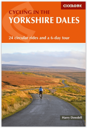
Fietsgids Cycling The Yorkshire Dales - Cicerone • 9781786310170
Fietsgids - Cycling The Yorkshire Dales - Cicerone Productomschrijving: Deze gids beschrijft 23-dagroutes, gesorteerd op afstand, klimgradatie en algehele helling, allemaal geschikt voor racefietsen en geïllustreerd met gedetailleerde kaarten en profielen. Bovendien neemt een route van zes etappes alle hoogtepunten in beslag, waaronder Grassington, Leyburn, Hawes, Kirkby Stephen, Ingleton …

Fietsgids Pennine Bridleway cycling - Cicerone • 9781852846558
Fietsgids Pennine Bridleway cycling - Cicerone Productomschrijving: Handige gids voor iedereen die de Walliser Bridleway National Trail wenst te fietsen. Meer dan 140km van berg fietsen die door Lancashire en de Yorkshire Dales lopen, samen met een linksom route rond de helft van de Mary Towneley Loop. 11 circulaire dag MTB routes in de Yorkshire Dales met behulp van de Bridleway zijn ook …

Mountainbikegids Yorkshire Dales mountain biking - Cicerone • 9781852846763
Mountainbikegids - Yorkshire Dale mountain biking - Cicerone Productomschrijving: Een handige gids over 30 korte, middellange, lange en volledig-dag MTB routes over het Yorkshire Dales National Park, de speeltuin van de bergfietser van Noord-Engeland. Circulaire ritten bezoeken de grote valleien en nemen lussen rond twee van de drie pieken, Whernside en Pen-y-Gent. Kies een route door midd…