

Fietsgids Cycling The Yorkshire Dales - Cicerone
23-routes gesorteerd op afstand- klimgradatie en helling


Korte omschrijving
Fietsgidsen Yorkshire, England van CICERONE Press. Ideaal voor tochten in England.
Fietsgids - Cycling The Yorkshire Dales - Cicerone Productomschrijving: Deze gids beschrijft 23-dagroutes, gesorteerd op afstand, klimgradatie en algehele helling, allemaal geschikt voor rac...

Specificaties
- Uitgever: CICERONE Press
- ISBN-13: 9781786310170
- HOOFDCATEGORIEËN: Fietsgids
- Activiteiten: Fietsen / VTT / MTB
- Auteur: Harry Dowdell
- Regio: Yorkshire, England
- Land: England
- Editie: 2
- Taal: Engels
- Fietsen: Fietsen in het Buitenland
- De Engelse Graafschappen: Yorkshire
Volledige omschrijving
Fietsgids - Cycling The Yorkshire Dales - Cicerone
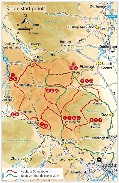
Productomschrijving: Deze gids beschrijft 23-dagroutes, gesorteerd op afstand, klimgradatie en algehele helling, allemaal geschikt voor racefietsen en geïllustreerd met gedetailleerde kaarten en profielen. Bovendien neemt een route van zes etappes alle hoogtepunten in beslag, waaronder Grassington, Leyburn, Hawes, Kirkby Stephen, Ingleton en Settle. En voor degenen die zichzelf echt willen testen, is de route van de Stage 1 van de Tour de France 2014, een 206 km-lus van Leeds naar Harrogate, ook inbegrepen, met een optie om de lus te sluiten zonder veel extra km toe te voegen.
Engelse omschrijving: This guide describes 23 day routes, graded by a combination of distance, climb and overall gradient, all suitable for road bikes and illustrated by detailed maps and profiles. In addition a six-stage tour takes in all the highlights, including Grassington, Leyburn, Hawes, Kirkby Stephen, Ingleton and Settle. And for those who really want to test themselves, the route of the Stage 1 of the 2014 Tour de France, a 206km loop from Leeds to Harrogate, is also included, with an option to close the loop without adding many extra miles.
Appendices include a route summary table to help you choose your route, lots of information about facilities for cyclists along the routes, taking bikes on public transport and basic bike maintenance.
The Vuelta a Dales takes in the best dales, passes and viewpoints as it passes through Grassington, Leyburn, Hawes, Kirkby Stephen, Sedbergh, Ingleton and Settle. The Yorkshire Dales have always welcomed visitors who enjoy the views. For cyclists, the national park and the areas overlapping its boundaries provide a splendid mix of varied scenic landscapes, an extensive network of roads and peaceful lanes and many cycle-friendly cafés and tea shops. With almost every turn revealing yet another stunning view, the Dales are an ideal area to explore by bike.
Locatie op kaart
Artikelen uit dezelfde regio
Wandelkaart Cleveland Way - Across North York NP - Harvey maps • 9781851374892
Wandelkaart Cleveland Way - Across North York NP - Harvey maps Productomschrijving: 174km (109 mijl) van Helmsley over het North York Moors National Park naar Saltburn en langs de kust via Scarborough eindigend met Filey. Informatie over het vinden van accommodatie, camping, voedsel. Routebeschrijving naar het begin. Ook Ranger Service contacten met nummers en uitbreidingen van steden/dorp…
Mountainbikegids North York Moors Mountain Biking - Vertebrate • 9781839811920
North York Moors Mountain Biking - Vertebrate Productomschrijving: North York Moors Mountain Biking – Moorland Trails is the fully updated second edition of the bestselling guide to some of the finest mountain biking in the North of England. Featured are over 20 of the best mountain bike rides in the North York Moors, between 10 and 76 Km in length, suitable for all levels of mountain bik…

Reisgids Yorkshire - Rough Guides • 9781835290583
Reisgids Yorkshire - Rough Guides Productomschrijving: The Rough Guide to Yorkshire was the first comprehensive guidebook to England’s largest county. Detailed coverage of the ruggedly beautiful Dales and Moors, the magnificent North Sea coast and historic York rubs shoulders with penetrating insights into the multi-cultural cities of Leeds and Sheffield, the resurgent port of Hull, and th…

Wandelgids Nidderdale short walks - Cicerone • 9781786311542
Nidderdale short walks - Cicerone Productomschrijving: Jon Fallis heeft 15 van de beste korte wandelingen rond Nidderdale in de Yorkshire Dales voor u uitgezocht. Onze gids is voorzien van goed leesbare Ordnance Survey-kaarten en duidelijke routebeschrijvingen, perfect als u voor het eerst gaat wandelen of iets zoekt waar u met het hele gezin van kunt genieten. We hebben informatie opgenom…

Wandelgids North York Moors walking guide - Cicerone • 9781852849511
Wandelgids - North York Moors walking guide - Cicerone Productomschrijving: Dit zeer bekende nationale park behoort tot de mooiste van Engeland. Het park is waliswaar zonder hoge bergtoppen, maar is en blijft een prachtig gebied, waar de Engelsen goed voor zorgen. Deze gids brengt u een dikke 50 wandelingen doorheen de North York Moors Nationaal Park. Kies er éne uit en neem een duik in de…