

Wandelgids Cotswold Way - Trailblazer Publications
Chipping Campden to Bath - 164 km

Korte omschrijving
Wandelgidsen Gloucestershire, Egland van Trailblazer Publications. Ideaal voor tochten in England.
The Cotswold Way - Trailblazer Publications Productomschrijving: Chipping Campden tot Bath met 49 maps en 30 kleurfoto's. The Cotswolds Way loopt door het befaamd Cotswold AONB (Area of Outs...

Specificaties
- Uitgever: Trailblazer Publications
- ISBN-13: 9781912716418
- HOOFDCATEGORIEËN: Wandelgids
- Activiteiten: Wandelen, Hiking & Trekking
- Auteur: Bob Hayne, Tricia Hayne
- Regio: Gloucestershire, Egland
- Land: England
- Lange afstand wandelroutes: Cotswold Way, England (164km)
- AONB - Area of Outstanding Beauty/National Landscape: Cotswolds AONB
- Editie: 5
- Taal: Engels
- National Trails UK, England & Wales: Cotswolds Way, England
Volledige omschrijving
The Cotswold Way - Trailblazer Publications
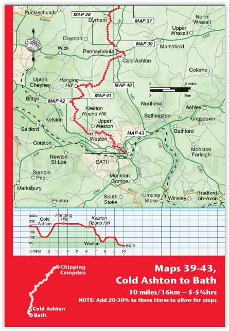
Productomschrijving: Chipping Campden tot Bath met 49 maps en 30 kleurfoto's. The Cotswolds Way loopt door het befaamd Cotswold AONB (Area of Outstanding Natural Beauty, of regio van uitmunend natuurschoon. The Cotswold Way, is een zeer goed gekende route van een dikke 164 km lang en biedt alles voor de natuurliefhebber.
Engelse omschrijving: The Cotswold Way is a 102-mile (163km) National Trail that runs from Chipping Campden to Bath, following the beautiful Cotswold escarpment for much of its course. The trail leads through quintessentially English countryside with little villages of honey-coloured stone, from open farmland to the historic city of Bath. Includes accommodation, pubs and restaurants in detailed guides to 48 towns and villages along or near the route.
This new 5th edition has been completely rewalked and all the information checked and updated.
- Includes 44 detailed walking maps: The largest-scale maps available
- Unique mapping features, walking times, directions, tricky junctions, places to stay, places to eat, points of interest.
- Itineraries for all walkers, whether hiking the entire route or sampling highlights on day walks or short breaks.
- Practical information for all budgets – what to see; where to eat (cafés, pubs and restaurants); where to stay (B&Bs, hotels, hostels and campsites).
- All places that offer baths (as well as/instead of showers) are mentioned, as are those that accept dogs – both being important features for many walkers.
- Detailed public transport information for all access points for day walkers
- Full city guide to Bath
- Overview map and trail profiles
- Waypoints now include what3ways references.

Artikelen uit dezelfde regio

Wandelgids Cotswolds AONB 50 walks guide - AA Publishing • 9780749583224
Cotswolds AONB - 50 walks guide - AA Publishing Productomschrijving: Wandelen is een van de favoriete vrijetijdsbestedingen van Groot-Brittannië. AA 50 Walks in the Cotswolds bevat een verscheidenheid aan uitgestippelde wandelingen van 3 tot 12 km, geschikt voor alle niveaus. Het boek bevat alle praktische details die u nodig hebt, vergezeld van boeiende achtergrondinformatie over de gesch…

Wandelkaart 169 Cirencester & Swindon - England - OSI • 9780319470411
Wandelkaart Cirencester & Swindon- Gloucestershire Omvat ook: Fairford & Cricklade. Productbeschrijving: Kaart nummer 169 in de OS Explorer kaarten reeks heeft betrekking op een gebied van Cirencester en Fairford met een gedeelte van de Cotswolds AONB in het noorden, tot de North Wessex Downs AONB in het zuiden. De nationale routes van Thames pad en Ridgeway vallen onder deze kaart, sa…
Wandelkaart 163 Cheltenham & Cirencester- England - OSI • 9780319474860
Wandelkaart Cheltenham & Cirencester - Gloucestershire England Productbeschrijving: De way of the Cotswold, Thames path en de Europese lange afstand pad, doorsnijden allemaal de op de OS Landranger vallende regio E2 kaart 163, waardoor het een fantastische locatie is om te wandelen en het landschap op te nemen. Cheltenham, het Cultuurcentrum vernoemd naar de Cotswolds, is een historische s…

Wandelkaart OL45 - The Cotswolds AONB- Gloucestershire - OSI • 9780319469637
Wandelkaart The Cotswolds AONB - Gloucestershire England Omvat ook: Burford, Chipping Campden, Cirencester & Stow-on-the-Wold Productbeschrijving: Kaart nummer OL45 in de OS Explorer kaarten reeks heeft betrekking op een groot gebied van de Cotswolds AONB, inclusief Stow-on-the-Wold, Burford, Cirencester & Chipping Campden. Hoogtepunten van het gebied: de Cotswold hills, Wychwood comm…
Wandelkaart 179 Gloucester- Cheltenham & Stroud - OSI • 9780319243725
Wandelkaart Gloucester- Cheltenham & Stroud - Gloucestershire Productbeschrijving: Gloucester & Cheltenham 179 / Gloucester, Cheltenham & Stroud, Gloucestershire, England - Kaart nummer 179 in de OS Explorer reeks heeft betrekking op de omgeving van Gloucester, Cheltenham, Stroud. Hoogtepunten van het gebied zijn onder meer: The Cotswolds AONB gebied van uitzonderlijke natuurlijke scho…