

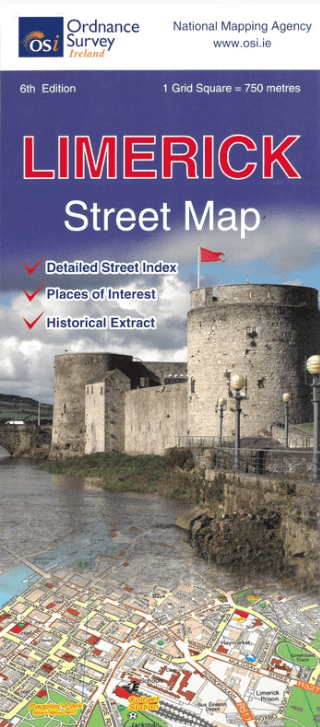
Stadsplattegrond Discovery Series Limerick city Ireland - OSI
County Limerick Ireland
Korte omschrijving
Stadskaart Limerick city Ireland - OSI Productomschrijving: Limerick Street Map at a scale of 1:13,000 Large Fold Out Street map including street names and index.

Specificaties
- Uitgever: Ordnance Survey Ireland
- ISBN-13: 9781908852823
- HOOFDCATEGORIEËN: Stadskaart plattegrond
- Activiteiten: Street/Road maps & city plans
- Regio: County Limerick, Ireland, Ierland, Ireland
- Land: Ierland
- Schaal: 1:13000
- Editie: 6
- Taal: Engels
- Reeks/Serie: Discovery Series, OSI
Volledige omschrijving
Stadskaart Limerick city Ireland - OSI
Productomschrijving: Limerick Street Map at a scale of 1:13,000
Large Fold Out Street map including street names and index.
Locatie op kaart
Artikelen uit dezelfde regio

Wandelkaart 74 County Cork, Limerick, Tipperary & Waterford - OSI • 9781908852908
Wandelkaart County Cork, Limerick, Tipperary & Waterford - OSI Productomschrijving: Ontdek Ierland met de Discovery Series Wandelkaarten van Ordnance Survey Ireland. Omvat de Counties: Cork, Limerick, Tipperary & Waterford De Discovery Series wandelkaarten van Ordnance Survey Ireland (OSi) zijn dé keuze voor wandelaars, fietsers en avonturiers die Ierland echt willen verkennen. De…

Landkaart Wegenkaart 713 Groot-Brittannië & Ierland 26 - Michelin • 9782067270220
Wegenkaart 713 Groot-Brittannië & Ierland 2026 - Michelin Productomschrijving: Deze kaart omvat de nieuwe versie voor 2026, met alle straten, hoofdwegen, toeristische informatie en locaties voor Groot-Brittannië & Ierland 2026 - Nationale kaarten - Wegenkaarten national: een overzicht van het land voor lange trajecten - Schaal aangepast aant het land - Kaarten met jaartal voor de…

Wandelkaart 23 County Mayo North Coast Discovery Series - OSI Ireland • 9781912140527
Wandelkaart Mayo North - OSI Productomschrijving: Ontdek Ierland met de Discovery Series Wandelkaarten van Ordnance Survey Ireland. De Discovery Series wandelkaarten van Ordnance Survey Ireland (OSi) zijn dé keuze voor wandelaars, fietsers en avonturiers die Ierland echt willen verkennen. Deze hoogwaardige topografische kaarten bieden een gedetailleerd en nauwkeurig overzicht van het I…
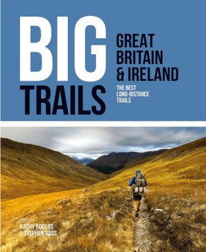
Wandelgids Big Trails DEEL 1 Great Britain & Ireland - Vertebrate • 9781839810008
Big Trails, Great Britain & Ireland - Vertebrate Productomschrijving: The best long-distance trails Big Trails: Great Britain & Ireland features 25 long-distance trails in England, Scotland, Wales, Northern Ireland and Ireland, and includes a general overview of the trails, specific technical information, overview mapping, key information and stunning photography. Big Trails: Great…
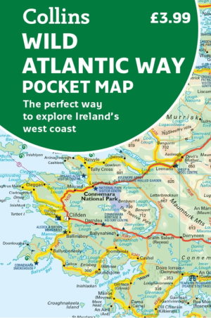
Landkaart Wegenkaart Wild Pocket map Wild Atlantic Way - Harper • 9780008780418
Wegenkaart Wild Pocket map Wild Atlantic Way - Harper Collins Productomschrijving: Handy full colour map of Ireland’s Wild Atlantic Way with a high level of detail. Clear mapping of the full 2500 km (over 1500 miles), showing the road network and places of interest.Ideal for tourists, locals, hikers and adventurers. Places of interest marked including famous film locations.Excellent value …