

Landkaart Wegenkaart SC7 & SC8 Baviaanskloof > Addo Tracks4Afrika
DEEL 4 Baviaanskloof > Addo Elephant National Park


Korte omschrijving
Wegenkaart SC7 & SC8 Baviaanskloof > Addo Elephant Park Productomschrijving: SC7 & SC8 : Baviaanskloof / Addo Elephant National Park Includes: Cape St. Francis, Humansdorp, Patensie, Ja...

Specificaties
- Uitgever: Tracks4Africa
- ISBN-13: 9781776322770
- HOOFDCATEGORIEËN: Wegenkaart - Landkaart
- Activiteiten: Street/Road maps & city plans
- Regio: Oost-Kaap, Zuid Afrika, West-Kaap, Afrika, Zuid-Afrika
- Land: Zuid-Afrika
- Nationale parken: Addo Elephant Park NP, Zuid-Afrika
- Schaal: 1:200000
- Editie: 1
- Taal: Engels
- Reeks/Serie: Cape to Addo maps, Tracks4Afrika
Volledige omschrijving
Wegenkaart SC7 & SC8 Baviaanskloof > Addo Elephant Park
Productomschrijving: SC7 & SC8 : Baviaanskloof / Addo Elephant National Park
Includes: Cape St. Francis, Humansdorp, Patensie, Jansenville, Jeffrey’s Bay, Kariega (Uitenhage), Kirkwood, Paterson, Colchester, Alexandria and Gqeberha (Port Elizabeth).
The Cape to Addo map series covers the southern parts of the Western Cape of South Africa in a series of eight highly detailed maps, printed on four sheets of A1 durable paper.
We start in Cape Town in the west and move along the southern coast through the Overberg, Winelands, Garden Route, Klein Karoo R62, Baviaanskloof to eventually arrive in the Addo National Park up to Gqeberha (Port Elizabeth) in the east. The maps are highly detailed and well researched. Our map scale is 1:200 000 which allows us to show a lot of detail including minor gravel roads, hiking trails, farm boundaries and points of interest which are relevant to self-drive tourists.
The size of the paper is kept small enough to allow this to be the perfect road tripping map. We use Duraflex paper and print two maps per sheet of A1 paper, making this a four-sheet series. Each map sheet is individually packed in a plastic protective sleeve.
The maps are perfect for day drives, overlanding or just doing road trips in your sedan, 4WD or motorbike along our beautiful southern coast, Klein Karoo and parts of the proper Karoo. Mountain passes form a prominent feature in this area, and these are indicated together with scenic route options. As with other Tracks4Africa maps, these maps include drive times over and above driving distances. Adventure bikers will be pleased to know that minor gravel roads are included together with various accommodation options.
The map has a relief background onto which farm boundaries, protected areas and other geographical features are shown.
For each town we indicate what basic services are offered, e.g. fuel, shops, camping accommodation. We also show the facilities and activities of the various nature reserves.
SC7 & SC8 : Baviaanskloof to Addo :
The Addo Elephant National Park is world famous and forms the main feature on these two maps. Along with it we cover the eastern section of the Baviaanskloof and we continue with the Garden Route between Cape St. Francis to Gqeberha (Port Elizabeth).
These two maps are printed on either side of a single sheet of Duraflex paperand stretch from Cape St. Francis in the west to Alexandria in the east. The coastline forms the southern boundary and to the north it includes places like Jansenville and Middleton. Key areas of interest include the eastern section of the Garden Route and Baviaanskloof, the Addo Elephant National Park and places like Cape St. Francis and Jeffrey’s Bay for its world-famous surfing.

Gekoppelde artikelen

Landkaart Wegenkaart SC1 & SC2 Cape Town > Montagu- Tracks4Afrika • 9781776322749
standaard versieWegenkaart SC1 & SC2 Cape Town > Montagu Productomschrijving: SC1 & SC2 : Cape Peninsula, Boland, Winelands, False Bay, Walker Bay and the Overberg region. Omvat: Cape Peninsula, Boland, Winelands, False Bay, Walker Bay and the Overberg region. The Cape to Addo map series covers the southern parts of the Western Cape of South Africa in a series of eight highly detailed maps, print…

Landkaart Wegenkaart SC3 & SC4 Swellendam > Mossel Bay • 9781776322756
standaard versieWegenkaart SC3 & SC4 Swellendam > Mossel Bay Productomschrijving: SC3 & SC4 : Overberg, Klein Karoo along the R62, part of the Garden Route The Cape to Addo map series covers the southern parts of the Western Cape of South Africa in a series of eight highly detailed maps, printed on four sheets of A1 durable paper. We start in Cape Town in the west and move along the southern coast th…
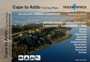
Landkaart Wegenkaart SC5 & SC6 George > Kareedouw - Tracks4Afrika • 9781776322763
standaard versieWegenkaart SC5 & SC6 George > Kareedouw Productomschrijving: SC5 & SC6 : Garden Route / Baviaanskloof Includes: George, Knysna, Willowmore, Uniondale, Wilderness, Plettenberg Bay, Storms River, Steytlerville and Kareedouw. The Cape to Addo map series covers the southern parts of the Western Cape of South Africa in a series of eight highly detailed maps, printed on four sheets of A…
Artikelen uit dezelfde regio

Reisgids Country Guide Botswana 2025-2026 - Gallimard • 9782305116754
Reisgids Botswana 2025-2026 - Gallimard Productomschrijving: Malgré sa beauté, le Botswana reste une destination quasiment ignorée des pays francophones. On dit de sa région Nord qu'elle serait le dernier Eden sauvage de l'Afrique. Le Botswana offre comme un royaume, un dernier lambeau de l'Afrique authentique où les traces de l'homme ne recouvrent pas encore celles des animaux.

Reisgids Cape Town - Lonely Planet • 9781787016729
Cape Town city guide - Lonely Planet Productomschrijving: Table Mountain is Cape Town’s star attraction, but South Africa’s brightest diamond of a city is also blessed with beautiful beaches, bountiful vineyards and a rainbow array of people, cultures and design. Coverage includes: Planning chapters, City Bowl, Foreshore, Bo-Kaap & De Waterkant, East City, District Six, Woodstock & Obs…
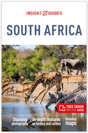
Reisgids South Africa - Insight Guides • 9781839053993
Reizen naar South Africa - Insight Guides Productomschrijving: South Africa is a land of exceptional natural beauty and cultural variety, a unique blend of of European, Asian and indigenous influences. This new edition covers everything from the modern cities of Johannesburg and Cape Town to the fascinating wildlife and scenery of its national parks and games reserves · Over 392 pages…
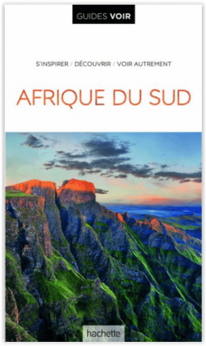
Guide Voir Afrique du Sud - Hachette • 9782017021612
Voir Afrique du Sud - Hachette Toerisme Productomschrijving: Deze nieuwe versie van de Guide Voir, is lichter, flexibeler en nog meer geïllustreerd, en laat u Zuid-Afrika ontdekken met unieke tekeningen van de belangrijkste bezienswaardigheden, honderden foto's en gedetailleerde kaarten. Een prachtige gids om te reizen of te dromen! Een moderne presentatie, pagina's die lezen als een t…

Reisgids Handbook Namibia - Footprint travel guide • 9781910120071
Reisgids Handbook Namibia - Footprint travel guide Productomschrijving: Namibië is een land in het zuidelijke Afrika, aan de kust van de Atlantische Oceaan tussen Angola en Zuid-Afrika. Deze reisgidsen zijn een soort handboekjes voor het bezoek aan het voorgestelde land. De gidsen zijn handig en zeer overzichtelijk, kwaliteitsvol & vol foto's en interessante weetjes, do's & dont's. Er …