

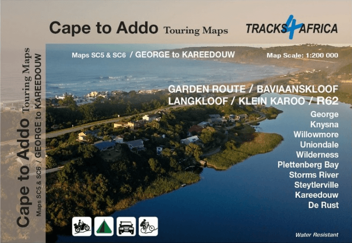
Landkaart Wegenkaart SC5 & SC6 George > Kareedouw - Tracks4Afrika
DEEL 3 George > Kareedouw
Korte omschrijving
Wegenkaart SC5 & SC6 George > Kareedouw Productomschrijving: SC5 & SC6 : Garden Route / Baviaanskloof Includes: George, Knysna, Willowmore, Uniondale, Wilderness, Plettenberg Bay, Storm...

Specificaties
- Uitgever: Tracks4Africa
- ISBN-13: 9781776322763
- HOOFDCATEGORIEËN: Wegenkaart - Landkaart
- Activiteiten: Street/Road maps & city plans
- Regio: Oost-Kaap, Zuid Afrika, Zuid Afrika
- Land: Zuid-Afrika
- Schaal: 1:200000
- Editie: 1
- Taal: Engels
- Reeks/Serie: Cape to Addo maps, Tracks4Afrika
Volledige omschrijving
Wegenkaart SC5 & SC6 George > Kareedouw
Productomschrijving: SC5 & SC6 : Garden Route / Baviaanskloof
Includes: George, Knysna, Willowmore, Uniondale, Wilderness, Plettenberg Bay, Storms River, Steytlerville and Kareedouw.
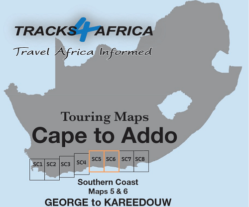
The Cape to Addo map series covers the southern parts of the Western Cape of South Africa in a series of eight highly detailed maps, printed on four sheets of A1 durable paper.
We start in Cape Town in the west and move along the southern coast through the Overberg, Winelands, Garden Route, Klein Karoo R62, Baviaanskloof to eventually arrive in the Addo National Park up to Gqeberha (Port Elizabeth) in the east.
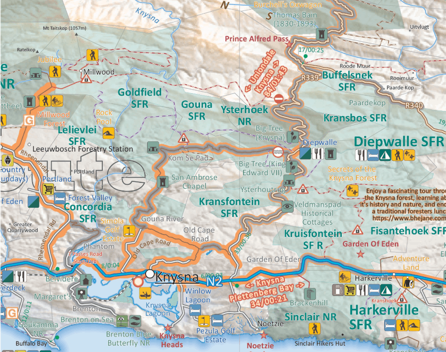
The maps are highly detailed and well researched. Our map scale is 1:200 000 which allows us to show a lot of detail including minor gravel roads, hiking trails, farm boundaries and points of interest which are relevant to self-drive tourists.
The size of the paper is kept small enough to allow this to be the perfect road tripping map. We use Duraflex paper and print two maps per sheet of A1 paper, making this a four-sheet series. Each map sheet is individually packed in a plastic protective sleeve.
The maps are perfect for day drives, overlanding or just doing road trips in your sedan, 4WD or motorbike along our beautiful southern coast, Klein Karoo and parts of the proper Karoo. Mountain passes form a prominent feature in this area, and these are indicated together with scenic route options. As with other Tracks4Africa maps, these maps include drive times over and above driving distances. Adventure bikers will be pleased to know that minor gravel roads are included together with various accommodation options.
The map has a relief background onto which farm boundaries, protected areas and other geographical features are shown.
For each town we indicate what basic services are offered, e.g. fuel, shops, camping accommodation. We also show the facilities and activities of the various nature reserves.
These two Maps – the SC5 & SC6 : George to Kareedouw, are dominated by the famous Garden Route, but it also includes lesser-known counterparts like the Langkloof Valley and the Baviaanskloof wilderness area, which is popular with adventure seekers on foot, MTB, adventure bike and 4WD. The map covers an area from the Karoo to coast which makes for some very diverse landscapes and stunning mountain passes. The coastline between George and Plettenberg Bay has some of the most stunning beaches in South Africa and the Indian Ocean ensures that it is much warmer to swim here than further west.
Expect lush green forest areas and deep valleys along the Garden Route between George and Storms River Mouth. Drive the famous Seven Passes Road between George and Knysna to experience a true forest meander, built by Thomas Bain. The Otter Hiking trail is possibly one of our most famous multi day hikes between Storms River Mouth and Nature’s Valley.
The Garden Route is packed with offerings to tourists. The famous Knysna lagoon and heads can be explored by boat cruise or get your adrenalin fix with the world’s highest bridge bungy jump at Bloukrans bridge near Nature’s valley. You have not camped until you pitched your tent at either Ebb & Flow in Wilderness or right in front of the massive waves at Storms River Mouth.
As the name suggests, these two maps, printed on either side of a single sheet of Duraflex paper, stretch from George in the west to Kareedouw in the east. The coastline forms the southern boundary and to the north it includes places like Klaarstroom, Willowmore and Steytlerville which are in the Karoo. Key areas of interest include the Garden Route between George and Storms River Mouth, Baviaanskloof wilderness area, Langkloof Valley and parts of the Klein Karoo.
Gekoppelde artikelen

Landkaart Wegenkaart SC1 & SC2 Cape Town > Montagu- Tracks4Afrika • 9781776322749
standaard versieWegenkaart SC1 & SC2 Cape Town > Montagu Productomschrijving: SC1 & SC2 : Cape Peninsula, Boland, Winelands, False Bay, Walker Bay and the Overberg region. Omvat: Cape Peninsula, Boland, Winelands, False Bay, Walker Bay and the Overberg region. The Cape to Addo map series covers the southern parts of the Western Cape of South Africa in a series of eight highly detailed maps, print…

Landkaart Wegenkaart SC3 & SC4 Swellendam > Mossel Bay • 9781776322756
standaard versieWegenkaart SC3 & SC4 Swellendam > Mossel Bay Productomschrijving: SC3 & SC4 : Overberg, Klein Karoo along the R62, part of the Garden Route The Cape to Addo map series covers the southern parts of the Western Cape of South Africa in a series of eight highly detailed maps, printed on four sheets of A1 durable paper. We start in Cape Town in the west and move along the southern coast th…

Landkaart Wegenkaart SC7 & SC8 Baviaanskloof > Addo Tracks4Afrika • 9781776322770
standaard versieWegenkaart SC7 & SC8 Baviaanskloof > Addo Elephant Park Productomschrijving: SC7 & SC8 : Baviaanskloof / Addo Elephant National Park Includes: Cape St. Francis, Humansdorp, Patensie, Jansenville, Jeffrey’s Bay, Kariega (Uitenhage), Kirkwood, Paterson, Colchester, Alexandria and Gqeberha (Port Elizabeth). The Cape to Addo map series covers the southern parts of the Western Cape of …
Artikelen uit dezelfde regio

Reisgids Southern Africa - Zuidelijk Afrika - Lonely Planet • 9781786570413
Reisgids Southern Africa - Lonely Planet Productomschrijving: An astonishingly diverse region fused by its prolific wildlife, breathtaking landscapes and remnants of ancient culture, Southern Africa is Africa at its most memorable. Lonely Planet will get you to the heart of Southern Africa, with amazing travel experiences and the best planning advice. Coverage Includes: Malawi, Zambia,…

Reisgids Zuid-Afrika - Insight Guides (NL) • 9789493423077
Reisgids Zuid-Afrika - Insight Guides Productomschrijving: Zuid-Afrika is een van de meest geliefde vakantiebestemmingen en heeft veel te bieden. Wildreservaten met de ‘Big-5’, zon, strand en schitterende landschappen. De auteurs en fotografen laten u op de bekende, onovertroffen en veelvuldig bekroonde Insight Guide-wijze kennismaken met dit spectaculaire land. In de eerste hoofdstukk…
Accomodatiegids Reisgids Namibia Self-Drive Guide - Tracks4Afrika • 9781776322794
Accomodatiegids Namibia - Tracks4Afrika Productomschrijving: Our Edition 3 is finally here! Completely revised and updated! So, what is so special about the Tracks4Africa guide books? These are not guides written by armchair travellers or the personal experience of one person, but the combined experiences of a whole community of travellers. The T4A community travel far and wide – not …

Reisgids Country Guide Botswana 2025-2026 - Gallimard • 9782305116754
Reisgids Botswana 2025-2026 - Gallimard Productomschrijving: Malgré sa beauté, le Botswana reste une destination quasiment ignorée des pays francophones. On dit de sa région Nord qu'elle serait le dernier Eden sauvage de l'Afrique. Le Botswana offre comme un royaume, un dernier lambeau de l'Afrique authentique où les traces de l'homme ne recouvrent pas encore celles des animaux.
Reisgids Namibië, Botswana & Zimbabwe - Gottmer • 9789465250083
Reisgids Namibië, Botswana & Zimbabwe - Gottmer Productomschrijving: In Namibië, Botswana en Zimbabwe zijn vrijwel alle denkbare landschappen vertegenwoordigd. Van tropische bossen op de oevers van de Zambezi tot aan het rode woestijnzand van de Namib, van naaldwouden in de Eastern Highland tot aan de steppe van de Kalahari. Het gebied heeft een boeiende historie; ver voordat de Europe…