

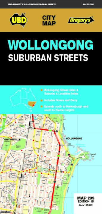
Landkaart Wegenkaart 299 Wollongong Suburban Streets NSW - UBD
Helensburgh- Dunmore- Berry & Nowra- North Nowra & Bomaderry
Korte omschrijving
Wegenkaart Wollongong Suburban Streets NSW - UBD Productomschrijving: Street level mapping and street index at a scale of 1 : 25 000 from Helensburgh in the north to Dunmore in the south. C...

Specificaties
- Uitgever: UBD Gregory's Universal Publishers
- ISBN-13: 9780731932054
- HOOFDCATEGORIEËN: Wegenkaart - Landkaart
- Activiteiten: Street/Road maps & city plans
- Regio: New South Wales, Australië
- Land: Australië
- Schaal: 1:25000
- Editie: 18
- Taal: Engels
- De Australische Regio's: New South Wales
Volledige omschrijving
Wegenkaart Wollongong Suburban Streets NSW - UBD
Productomschrijving: Street level mapping and street index at a scale of 1 : 25 000 from Helensburgh in the north to Dunmore in the south. Coverage included for Berry & Nowra, North Nowra & Bomaderry
- Index to suburbs & localities
- Overview map of Wollongong to Nowra at a scale of 1 : 685 700
Artikelen uit dezelfde regio

Landkaart Wegenkaart 244 Sydney to Brisbane - UBD Gregory's • 9780731933280
Wegenkaart Sydney to Brisbane - UBD Gregory's Productomschrijving: The latest edition of the Sydney to Brisbane touring map has been fully revised and updated and includes: - Information on travelling from Sydney to Brisbane via both the Pacific Motorway/Highway and the New England Highway. - Information on choosing to travel between Sydney and Brisbane via either the Pacific or N…
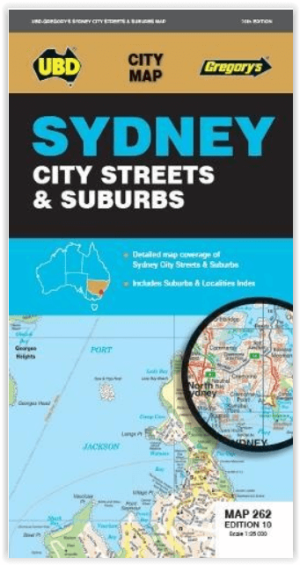

Stadsplattegrond 262 Sydney City Streets & Suburbs - Gregory's • 9780731933464
Stadskaart Sydney City Streets & Suburbs - UBD Gregory's Productomschrijving: The latest edition of the Sydney City Streets and Suburbs Map has been fully revised and updated and includes coverage at scales of 1:25 000 and 1: 100 000; One side features mapping of Sydney city and surrounding suburbs at a scale of 1: 25 000 with coverage along the coast from Dee Why in the north to Malab…

Landkaart Wegenkaart 283-298 S. Highlands & S. Coast NSW - UBD • 9780731931804
Wegenkaart Southern Highlands & South Coast NSW Productomschrijving: The latest edition of the Southern Highlands and South Coast NSW regional touring map has been fully revised and updated. It includes a regional touring map covering the coast from Shellharbour in the north to Eden in the south and west to Goulburn & Braidwood. There is also street level mapping and indexes at a scal…

Landkaart Wegenkaart 295 Port Stephens NSW - UBD Gregory's • 9780731931910
Wegenkaart Port Stephens New South Wales Productomschrijving: The latest edition of the Port Stephens touring map has been fully revised and updated and features: A regional touring map covering Port Stephens, Hawks Nest/Tea Gardens, Karuah, Lemon Tree Passage and Raymond Terrace. Maps and street index of Nelson Bay and surrounding suburbs. Maps of Hawks Nest/Tea Gardens, Karuah, Raym…
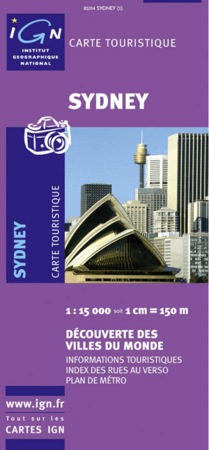
Landkaart Wegenkaart 85314 Sydney Australia - IGN • 9782758512370
Wegenkaart Sydney Australia - IGN Productomschrijving: Deze wegenkaart omvat het volledige Sydney op schaal 1:15.000 (1 cm = 150 m), hij bevat alle touristische wegen als ook Nationale parken. De kaart behoort tot de reeks van de Pays, Découverte du Monde van IGN