

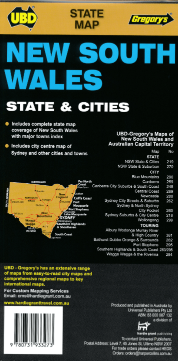
Landkaart Wegenkaart 219 New South Wales State & Cities - Gregory
Byron Bay- Gosford- Katoomba- Newcastle- Parramatta- Sydney

Korte omschrijving
Wegenkaart New South Wales State & Cities - Gregory's Productomschrijving: The latest edition of the New South Wales State and Cities Map has been fully revised and updated and includes. ...

Specificaties
- Uitgever: UBD Gregory's Universal Publishers
- ISBN-13: 9780731933273
- HOOFDCATEGORIEËN: Wegenkaart - Landkaart
- Activiteiten: Street/Road maps & city plans
- Regio: New South Wales, Australië
- Land: Australië
- Schaal: 1:1600000
- Editie: 11
- Taal: Engels
- De Australische Regio's: New South Wales
Volledige omschrijving
Wegenkaart New South Wales State & Cities - Gregory's
Productomschrijving: The latest edition of the New South Wales State and Cities Map has been fully revised and updated and includes.
State mapping at a scale of 1 : 1.600.000 with an index to major towns featured on one side.
Street level mapping for Byron Bay, Gosford, Katoomba, Newcastle, Parramatta, Sydney and Wollongong plus regional mapping for the Lower Hunter Valley and Snowy Mountains as well as touring information on the other side. This handy easy to carry fold out map is an essential tool to have with you when travelling through NSW or for anyone wanting to reference NSW roads & towns as well as information on the major city centres.

Artikelen uit dezelfde regio

Stadskaart plattegrond Melbourne NSW & omgeving - Hema Maps • 9781876413965
Stadskaart Melbourne & omgeving - Hema Productomschrijving: Melbourne CBD, City & Suburbs Map The Melbourne and Region map features a primary map of Greater Melbourne (1:115,000) that includes highways, major roads and local streets, as well as 24-hour fuel, parks and caravan parks. On the reverse is a Melbourne CBD map with accommodation, shopping and other places of interest pinpoin…

Landkaart Wegenkaart 283-298 S. Highlands & S. Coast NSW - UBD • 9780731931804
Wegenkaart Southern Highlands & South Coast NSW Productomschrijving: The latest edition of the Southern Highlands and South Coast NSW regional touring map has been fully revised and updated. It includes a regional touring map covering the coast from Shellharbour in the north to Eden in the south and west to Goulburn & Braidwood. There is also street level mapping and indexes at a scal…

Landkaart Wegenkaart 295 Port Stephens NSW - UBD Gregory's • 9780731931910
Wegenkaart Port Stephens New South Wales Productomschrijving: The latest edition of the Port Stephens touring map has been fully revised and updated and features: A regional touring map covering Port Stephens, Hawks Nest/Tea Gardens, Karuah, Lemon Tree Passage and Raymond Terrace. Maps and street index of Nelson Bay and surrounding suburbs. Maps of Hawks Nest/Tea Gardens, Karuah, Raym…

Landkaart Wegenkaart 244 Sydney to Brisbane - UBD Gregory's • 9780731933280
Wegenkaart Sydney to Brisbane - UBD Gregory's Productomschrijving: The latest edition of the Sydney to Brisbane touring map has been fully revised and updated and includes: - Information on travelling from Sydney to Brisbane via both the Pacific Motorway/Highway and the New England Highway. - Information on choosing to travel between Sydney and Brisbane via either the Pacific or N…
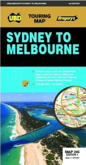
Landkaart Wegenkaart 245 Sydney to Melbourne NP - UBD Gregory's • 9780731933174
Wegenkaart Sydney to Melbourne NP - Gregory's Productomschrijving: The latest edition of the Sydney to Melbourne touring map has been fully revised and updated. It includes strip maps for travelling both the Princes Highway/Freeway and the Hume Motorway/Highway/Freeway with information on the major towns along these routes. There is also state mapping at a scale of 1: 975 000 highligh…