

Lancashire walking guide - 40 walks around the county - Cicerone
Beschrijft 39 rondwandelingen van 8 tot 18 km

Korte omschrijving
Wandelgidsen Lanacshire, England van CICERONE Press. Ideaal voor tochten in England.
Walking in Lancashire - 40 walks around the county Productomschrijving: Deze gids beschrijft 39 rondwandelingen van 5 tot 13 mijl en één lineaire route. Het landschap strekt zich uit van het...

Specificaties
- Uitgever: CICERONE Press
- ISBN-13: 9781786310033
- HOOFDCATEGORIEËN: Wandelgids
- Activiteiten: Wandelen, Hiking & Trekking
- Auteur: Mark Sutcliffe
- Regio: Lanacshire, England
- Land: England
- Editie: 1, 3
- Taal: Engels
- De Engelse Graafschappen: Lancashire
Volledige omschrijving
Walking in Lancashire - 40 walks around the county
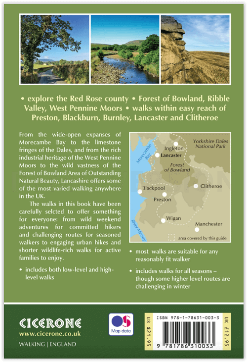
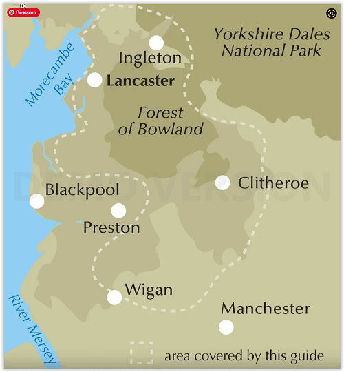
Productomschrijving: Deze gids beschrijft 39 rondwandelingen van 5 tot 13 mijl en één lineaire route. Het landschap strekt zich uit van het laaggelegen land rond Cockerham, Lytham, Martin Mere en Croston tot de hoogten van Boulsworth Hill, Ward's Stone, Fair Snape Fell en Pendle Hill. Alle wandelingen zijn geschikt voor de meeste mensen, voornamelijk over paden en paden.
Engelse omschrijving: This guidebook describes 39 circular day walks from 5 to 13 miles and one linear route. The countyside ranges from the low lying land around Cockerham, Lytham, Martin Mere and Croston to the heights of Boulsworth Hill, Ward's Stone, Fair Snape Fell and Pendle Hill. All walks are suitable for most abilities, mainly following paths and tracks.
Seasons:
All seasons, though winter will be cold on the fell-tops.
Centres:
Lancaster, Carnforth, Clitheroe, Whalley, Lytham, Chorley.
DifficultyGentle strolls to fell-top hikes. The walks are suitable for all abilities.
Must See:
Pendle Hill, Clougha Pike, Slaidburn, Downham, Croston, river walks, coastal strolls, Whalley Abbey, Martin Mere.

Locatie op kaart
Artikelen uit dezelfde regio

Wandelkaart XT25 Forest of Bowland Lancashire England - Harvey • 9781851377206
Wandelkaart Forest of Bowland Lancashire - Harvey Maps Productomschrijving: Meer dan een kaart - een essentieel deel van je uitrusting. Deze nieuwe generatie HARVEY Superwalker kaarten is ontworpen om de meest praktische outdoor navigatietool te zijn. - De ideale kaart om het Forest of Bowland National Landscape te verkennen - Omvat Settle, Gisburn Forest en de Trough of Bowland - …

Wandelkaart 206 Edge Hill & Fenny Compton - OSI • 9780319243992
Wandelkaart Edge Hill & Fanny Compton - Warwickshire Productbeschrijving: Badby, Kineton & Middle Tysoe. 206 / Edge Hill & Fenny Compton, Warwickshire, England - Kaart nummer 206 in de OS Explorer kaart reeks is ideaal voor het ontdekken van het noordelijke deel van de Cotswolds. Dit gebied van uitzonderlijke natuurlijke schoonheid AONB kan worden bezocht dmv het aflopen van de Centen…

Wandelgids King Charles III England Coast Path Map Booklet • 9781786310415
King Charles III England Coast Path Map Booklet - Cicerone Productomschrijving: This map booklet to the Lancashire and Merseyside section of the England Coast Path contains detailed mapping for walking the route in either direction. With easy access at many points along the way, the Lancashire/Merseyside section can be enjoyed as a trek of around 12 days or in shorter sections. - Full…

Mountainbikegids Yorkshire Dales mountain biking - Cicerone • 9781852846763
Mountainbikegids - Yorkshire Dale mountain biking - Cicerone Productomschrijving: Een handige gids over 30 korte, middellange, lange en volledig-dag MTB routes over het Yorkshire Dales National Park, de speeltuin van de bergfietser van Noord-Engeland. Circulaire ritten bezoeken de grote valleien en nemen lussen rond twee van de drie pieken, Whernside en Pen-y-Gent. Kies een route door midd…

Wandelkaart Fietskaart Forest of Bowland - Harvey maps • 9781851374731
Wandelkaart - Fietskaart Forest of Bowland - Harvey maps Productomschrijving: Deze kaart van de Forest of Bowland is 2-in-1. Aan de ene kant is een wandelkaart; aan de andere een kaart geschikt voor fietsers. De Forest of Bowland heeft veel te bieden voor wandelaars, ruiters en fietsers, en deze praktische kaart zal u helpen om dit prachtige deel van Engeland te verkennen. De wandelaar…