

Fietsgids Lancashire cycleway - Cicerone
Lancashire- The tour & 17 day rides


Korte omschrijving
Fietsgidsen Lanacshire, England van CICERONE Press. Ideaal voor tochten in England.
Fietsgids Lancashire cycleway - Cicerone Productomschrijving: Lancashire is een graafschap in de Engelse regio North West England Detail uitgever: Comprising two distinct loops that int...

Specificaties
- Uitgever: CICERONE Press
- ISBN-13: 9781852848491
- HOOFDCATEGORIEËN: Fietsgids
- Activiteiten: Fietsen / VTT / MTB
- Regio: Lanacshire, England
- Land: England
- Editie: 2
- Taal: Engels
- Fietsen: Fietsen in het Buitenland
- De Engelse Graafschappen: Lancashire
Volledige omschrijving
Fietsgids Lancashire cycleway - Cicerone
Productomschrijving: Lancashire is een graafschap in de Engelse regio North West England
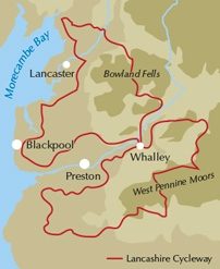
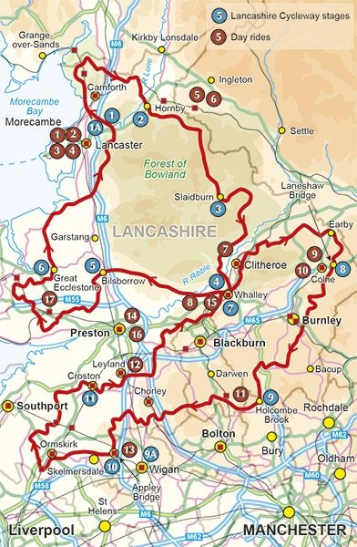
Detail uitgever: Comprising two distinct loops that intersect at Whalley in the Ribble Valley, the 425km (265 mile) Lancashire Cycleway showcases the idyllic scenery of England's historic Red Rose County. The Northern Loop contrasts the quiet lanes and peaceful countryside of northwestern Lancashire with the thrill of the open moors of the Forest of Bowland AONB; the Southern weaves its way between the villages and towns in the south of the county, an area rich in social history. Easily accessible from the region's rail network, the route – which is all on-road – can be cycled either as a tour or a series of day rides.
Locatie op kaart
Artikelen uit dezelfde regio

Mountainbikegids Yorkshire Dales mountain biking - Cicerone • 9781852846763
Mountainbikegids - Yorkshire Dale mountain biking - Cicerone Productomschrijving: Een handige gids over 30 korte, middellange, lange en volledig-dag MTB routes over het Yorkshire Dales National Park, de speeltuin van de bergfietser van Noord-Engeland. Circulaire ritten bezoeken de grote valleien en nemen lussen rond twee van de drie pieken, Whernside en Pen-y-Gent. Kies een route door midd…

Wandelkaart XT25 Forest of Bowland Lancashire England - Harvey • 9781851377206
Wandelkaart Forest of Bowland Lancashire - Harvey Maps Productomschrijving: Meer dan een kaart - een essentieel deel van je uitrusting. Deze nieuwe generatie HARVEY Superwalker kaarten is ontworpen om de meest praktische outdoor navigatietool te zijn. - De ideale kaart om het Forest of Bowland National Landscape te verkennen - Omvat Settle, Gisburn Forest en de Trough of Bowland - …

Wandelgids King Charles III England Coast Path Map Booklet • 9781786310415
King Charles III England Coast Path Map Booklet - Cicerone Productomschrijving: This map booklet to the Lancashire and Merseyside section of the England Coast Path contains detailed mapping for walking the route in either direction. With easy access at many points along the way, the Lancashire/Merseyside section can be enjoyed as a trek of around 12 days or in shorter sections. - Full…

Wandelkaart Fietskaart Forest of Bowland - Harvey maps • 9781851374731
Wandelkaart - Fietskaart Forest of Bowland - Harvey maps Productomschrijving: Deze kaart van de Forest of Bowland is 2-in-1. Aan de ene kant is een wandelkaart; aan de andere een kaart geschikt voor fietsers. De Forest of Bowland heeft veel te bieden voor wandelaars, ruiters en fietsers, en deze praktische kaart zal u helpen om dit prachtige deel van Engeland te verkennen. De wandelaar…

Wandelkaart 206 Edge Hill & Fenny Compton - OSI • 9780319243992
Wandelkaart Edge Hill & Fanny Compton - Warwickshire Productbeschrijving: Badby, Kineton & Middle Tysoe. 206 / Edge Hill & Fenny Compton, Warwickshire, England - Kaart nummer 206 in de OS Explorer kaart reeks is ideaal voor het ontdekken van het noordelijke deel van de Cotswolds. Dit gebied van uitzonderlijke natuurlijke schoonheid AONB kan worden bezocht dmv het aflopen van de Centen…