

Wandelkaart Wales Coast Path DEEL 1 - Chester to Caernarfon
WCP Wales Coast Path - Gwynedd regio Noord Wales

Korte omschrijving
Wandelkaarten Gwynedd, Wales van HARVEY MAPS. Ideaal voor tochten in Wales.
Wales Coast Path DEEL 1 - Chester to Caernarfon - Harvey Maps Productomschrijving: Het Wales Coast Path is een 1400 km langeafstandspad dat de gehele kustlijn van Wales volgt of er dicht lan...

Specificaties
- Uitgever: HARVEY MAPS
- ISBN-13: 9781851376605
- HOOFDCATEGORIEËN: Wandelgids
- Activiteiten: Wandelen, Hiking & Trekking
- Regio: Gwynedd, Wales
- Land: Wales
- Schaal: 1:40000
- Taal: Engels
- Reeks/Serie: Superwalker XT40, Harvey Maps
- National Trails UK, England & Wales: Coast to Coast Walk, England
Volledige omschrijving
Wales Coast Path DEEL 1 - Chester to Caernarfon - Harvey Maps
Productomschrijving: Het Wales Coast Path is een 1400 km langeafstandspad dat de gehele kustlijn van Wales volgt of er dicht langs loopt. Het is een ongelooflijk gevarieerde route met ruige en ongerepte wandelingen, kleurrijke kustdorpen, industriële archeologie, kliftoppen, stranden en unieke erfgoedlocaties.
- 4 HARVEY kaarten bestrijken de gehele route. Elke kaart beslaat een deel van het pad dat geschikt is voor ongeveer 2 weken wandelen.
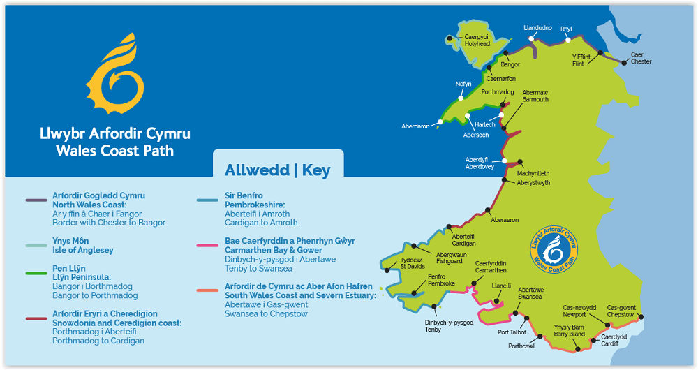
- Kaart 1 beslaat: het pad van de start in Chester tot Caernarfon, en omvat het gehele Anglesey kustpad.
Vanaf Chester, net over de grens in Engeland, loopt u een klein stukje naar de grens en het officiële begin van het Wales Coastal Path. In westelijke richting door Noord-Wales komt u door bruisende badplaatsen en zandstranden, voordat u de Menai Strait en het eiland Anglesey bereikt.
Engelse omschrijving: The Wales Coast Path is a 1400km (870 miles) long distance trail that follows, or runs close to, the entire coastline of Wales. It is an incredibly varied trail that offers rugged and unspoilt walking, colourful seaside villages, industrial archaeology, clifftops, beaches and unique heritage sites.
- 4 HARVEY maps cover the whole of the route. Each map covers a section of the Path suitable for about 2 weeks of walking.
- Map 1 covers: the Path from the start in Chester to Caernarfon, and includes the whole of the Anglesey Coastal Path.
From Chester, just across the border in England, you will walk a short distance to the border and the official start of the Wales Coast Path. Heading west across North Wales, you will pass through bustling seaside towns and sandy beaches, before reaching the Menai Strait and the island of Anglesey
- The entire route on 4 maps - this is map 1
- Map 1 shows Chester to Caernarfon, 355km (221miles) in length, including the Anglesey Coastal Path
- A good two weeks’ walking on one map
- Information on accomodation and services
-Lightweight, detailed, clear and easy to read
- Printed on tough 100% waterproof, tearproof paper
- GPS compatible
Maps 2 and 3 OUT NOW. Maps 1 and 4 coming MAY 2023.
Experience the satisfaction of fine navigation with the Trail Map XT40, printed on 100% waterproof and almost indestructible paper, whatever the weather!
Artikelen uit dezelfde regio

Wandelkaart OL018 Harlech- Porthmadog & Y Bala - OS • 9780319263587
Wandelkaart Harlech- Porthmadog & Y Bala - OS Productomschrijving: Harlech- Porthmadog & Y Bala, Gwynedd Wales UK. Omvat: Harlech- Porthmadog & Y Bala & parts of Snowdonia National Park Ontdek de OL-serie van Ordnance Survey: De OL-serie (Outdoor Leisure) van Ordnance Survey is dé referentie voor wie gaat wandelen op de Britse eilanden. Deze topografische kaarten maken deel uit v…

Wandelkaart OL023 Cadair Idris & Llyn Tegid - OS • 9780319263594
Wandelkaart Cadair Idris & Llyn Tegid - OS Productomschrijving: Een topografische wandelkaart van een deel van het Snowdonia National park en omgeving. Omvat: Cadair Idris & Llyn Tegid, and parts of Snowdonia National Park Ontdek de OL-serie van Ordnance Survey: De OL-serie (Outdoor Leisure) van Ordnance Survey is dé referentie voor wie gaat wandelen op de Britse eilanden. Deze t…

Wandelkaart 125 Bala & Lake Vyrnwy- N. Wales - OSI • 9780319474488
Wandelkaart Bala & Lake Vyrnwy- Berwyn - Gwynedd N. Wales Productbeschrijving: Bala ligt in de prachtige valleien van de berg van het Snowdonia National Park, in een schilderachtige dorpje gedekt door OS Landranger kaart 125. Het biedt een scala aan activiteiten waaronder watersporten op de natuurlijke Bala Lake. Lake Vyrnwy is gelegen net buiten het Nationaal Park midden in de externe Ber…

Wandelkaart Snowdonia NP South - Harvey maps • 9781851374694
Wandelkaart Snowdonia NP South - Harvey maps Productomschrijving: De belangrijkste bergen van zuidelijke Snowdonia op één kaart, met inbegrip van Cadair Idris, de Arans en de Arenig Fawr afgedrukt op polyethyleen - duurzaam, scheurvast en 100% waterdicht. Deze serie is gemaakt in samenwerking met de British Council voor alpinisme en bevat kleurarcering voor gemakkelijke identificatie van d…

Wandelgids Snowdonia North - Cicerone • 9781852849849
Wandelgids - Snowdonia North - Cicerone Productomschrijving: De wandelingen in deze gids liggen in het noordelijke deel van Snowdonia National Park, dicht bij Conwy, Betws-y-Coed, Llanberis en Porthmadog. De meeste wandelingen duren twee uur, anderen variëren van twee tot zes uur. Elke wandeling heeft een bijbehorende Ordnance Survey 1: 25.000 of 1: 50.000 kaart met de route, eenvoudig te …