
Wandelkaart Adventure series Aran Islands C. Galway Ireland - OSI
Dún Eochla- Dún Chonchúir and the cliff fort of Dún Aonghusa

Korte omschrijving
Wandelkaarten County Galway, Ierland en Aran Islands, County Galway Ireland van Ordnance Survey Ireland. Ideaal voor tochten in Ierland.
Wandelkaart Aran Islands County Galway Ireland - OSI Productomschrijving: The Aran islands are a major tourist centre and a cultural treasure, rich in Irish language, history and traditiona...

Specificaties
- Uitgever: Ordnance Survey Ireland
- ISBN-13: 9781908852786
- HOOFDCATEGORIEËN: Wandelkaart
- Activiteiten: Wandelen, Hiking & Trekking
- Regio: Aran Islands, County Galway Ireland, County Galway, Ierland
- Land: Ierland
- Schaal: 1:25000
- Taal: Engels
- Reeks/Serie: Adventure Series, OSI
Volledige omschrijving
Wandelkaart Aran Islands County Galway Ireland - OSI
Productomschrijving: The Aran islands are a major tourist centre and a cultural treasure, rich in Irish language, history and traditional music. This map helps the visitor to explore the rugged landscape, and visit many interesting sites, including Dún Eochla, Dún Chonchúir, and the cliff fort of Dún Aonghusa +
The Adventure Series is an activity oriented map which shows detailed landscape information. It provides detailed mapping in specific locations for the outdoor enthusiast such as mountaineers, hill walkers, cyclists and other users of the Irish countryside.
Some of the features included are National Roads, National Secondary Roads, Regional Roads, Waymarked walks, Tracks and Trails, Cycle Routes, Forestry, Land Terrain, Spot Heights, Contours, Named antiquities, Local amenities, National Parks, Lakes, Rivers and Streams. The Series is printed on Water Resistant Paper for greater durability.

Locatie op kaart
Artikelen uit dezelfde regio
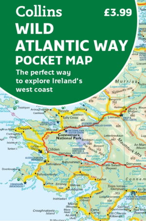
Landkaart Wegenkaart Wild Pocket map Wild Atlantic Way - Harper • 9780008780418
Wegenkaart Wild Pocket map Wild Atlantic Way - Harper Collins Productomschrijving: Handy full colour map of Ireland’s Wild Atlantic Way with a high level of detail. Clear mapping of the full 2500 km (over 1500 miles), showing the road network and places of interest.Ideal for tourists, locals, hikers and adventurers. Places of interest marked including famous film locations.Excellent value …

Wandelkaart 40 County Galway, Longford & Roscommon - OSI • 9781908852625
Wandelkaart Counties Galway, Longford & Roscommon - OSI Productomschrijving: Ontdek Ierland met de Discovery Series Wandelkaarten van Ordnance Survey Ireland. De Discovery Series wandelkaarten van Ordnance Survey Ireland (OSi) zijn dé keuze voor wandelaars, fietsers en avonturiers die Ierland echt willen verkennen. Deze hoogwaardige topografische kaarten bieden een gedetailleerd en na…

Wandelkaart 44 County Galway Coastline - OSI • 9781912140169
Wandelkaart County Galway Coastline - OSI Productomschrijving: Ontdek Ierland met de Discovery Series Wandelkaarten van Ordnance Survey Ireland. De Discovery Series wandelkaarten van Ordnance Survey Ireland (OSi) zijn dé keuze voor wandelaars, fietsers en avonturiers die Ierland echt willen verkennen. Deze hoogwaardige topografische kaarten bieden een gedetailleerd en nauwkeurig overz…

Stadsplattegrond Discovery Series Galway city Ireland - OSI • 9781908852731
Stadskaart Galway city Ireland - OSI Productomschrijving: Galway on an indexed street plan at 1:12,000 from Ordnance Survey of Ireland with an enlargement showing the city centre in greater detail. Street index, placed under the main map, which lists streets with their names in both Irish and English. OSI street plans highlight main traffic arteries in each town, national primary and …

Wandelkaart 52 County Clare & Galway (Kust verwijderd) - OSI • 9781912140640
Wandelkaart County Clare & Galway - OSI Productomschrijving: Ontdek Ierland met de Discovery Series Wandelkaarten van Ordnance Survey Ireland. Omvat: de Counties Clare & Galway, van de kust verwijderd De Discovery Series wandelkaarten van Ordnance Survey Ireland (OSi) zijn dé keuze voor wandelaars, fietsers en avonturiers die Ierland echt willen verkennen. Deze hoogwaardige topogr…