

Wandelkaart 820 Mount Hood & Willamette National Forest
Met een dikke 6,790.75 km² grote

Korte omschrijving
Wandelkaarten Oregon, USA van National Geographic. Ideaal voor tochten in Verenigde Staten van Amerika (USA).
TOPO Wandelkaart 820 - Mount Hood & Willamette National Forest - Oregon USA - National Geographic Productomschrijving: Het Willamette National Forest is een National bos gelegen in het centr...

Specificaties
- Uitgever: National Geographic
- ISBN-13: 9781566954723
- HOOFDCATEGORIEËN: Wandelkaart
- Auteur: National Geographic
- Regio: Oregon, USA
- Land: Verenigde Staten van Amerika (USA)
- Regionale parken: Willamette National Forest, Oregon USA
- TOPO's & Stafkaarten: Topografisch wandelen
- Schaal: 1:75000
- Taal: Engels
Volledige omschrijving
TOPO Wandelkaart 820 - Mount Hood & Willamette National Forest - Oregon USA - National Geographic
Productomschrijving: Het Willamette National Forest is een National bos gelegen in het centrale deel van de Cascade Range in de U.S. satta van Oregon. Met een dikke 6,790.75 km². Een deel van 1,540 km² is echte wildernis waarin 7 grote pieken zijn vertegenwoordigd.
Engelse omschrijving: With its snow-covered peak, Mount Hood is an American icon and a premier destination for outdoor enthusiasts. The area's mountains, forests, wildernesses and rivers, provide an abundance of year-round recreation activities. National Geographic's Trails Illustrated map of Mount Hood is expertly researched and created in partnership with the U.S. Forest Service and others, to provide unparalleled detail for anyone wishing to explore this magnificent area. Included in the map are Mount Hood and Willamette National Forests, Mount Hood National Recreation Area, Olallie Lake Scenic Area, Sandy and Clackamas Rivers, Badger Creek and Timothy Lake. Descriptions of the region's eight wilderness areas are also provided, including Badger Creek, Bull of the Woods, Mount Hood and Salmon-Huckleberry Wilderness Areas.
With clearly marked trails including the Pacific Crest Trail and the Oregon National Historic Trail, and such scenic roadways as the West Cascades and Mount Hood Scenic Byways, this map will prove invaluable whether you're taking in the scenery on foot, by bike, on horseback or by car. Among the many recreation and adventure features noted on the map are campgrounds and primitive campsites, rock climbing areas, river access and boat launch points, ski areas and sno-parks, fishing areas and lookout towers. Also included are permit and background information and safety tips for climbing Mount Hood as well as essential contact information. Every Trails Illustrated map is printed on "Backcountry Tough" waterproof, tear-resistant paper. A full UTM grid is printed on the map to aid with GPS navigation.
Other features found on this map include: Badger Creek Wilderness, Barlow Pass, Battle Ax, Bull of the Woods Wilderness, Bull Run Reservoir Number One, Clackamas Wilderness, Detroit Lake, Fish Creek Mountain, Hunchback Mountain, Mount Hood, Mount Hood Wilderness, Mount Jefferson Wilderness, Mt. Hood National Forest, Olallie Butte, Opal Creek Wilderness, Roaring River Wilderness, Salmon-Huckleberry Wilderness, Shellrock Mountain, Timothy Lake, Wanderers Peak, Wapinitia Pass, Willamette National Forest, Zigzag Mountain.
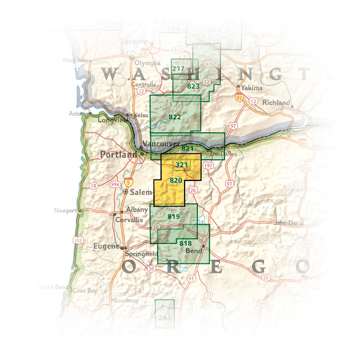
Locatie op kaart
Overzichtskaarten

NAT GEO Oregon trails map
NAT GEO Oregon trails map

Producten op de overzichtskaart
Klik op een product om naar de detailpagina te gaan.
Artikelen uit dezelfde regio

Wandelgids Pacific Crest Trail Hiking - Cicerone • 9781786312129
Hiking the Pacific Crest Trail - Cicerone Productomschrijving: A comprehensive three-book set providing all the information needed to prepare for and hike the Pacific Crest Trail (PCT), a 2650-mile hike (4265 Km) through California, Oregon and Washington. Designed to be compact and lightweight, the set is separated into three books, an introduction to the trail (130g) and two map books (2…

Reisgids Pacific Northwest USA - DK Eyewitness • 9780241411513
DK Eyewitness Pacific Northwest USA Omvat: Portland, Oregon, Seattle, Washington, Vancouver and British Columbia Productomschrijving: Tour de Wine Country van de North Willamette Valley, ga wandelen in het Mount Rainier National Park of verken het natuurschoon van Vancouver Island: alles wat u moet weten is overzichtelijk weergegeven in kleurgecodeerde hoofdstukken. Ontdek het beste v…

Wandelkaart 818 Bend & Three Sisters Oregon USA - Nat Geo • 9781566956628
Wandelkaart Bend- Three Sisters Oregon USA - Nat Geo Productomschrijving: National Geographic's Trails Illustrated kaart van Bend en Three Sisters is ontworpen om te voldoen aan de behoeften van outdoor enthousiastelingen die de bergen en wildernissen in dit deel van centraal Oregon willen verkennen. Met drie van Oregon's hoogste toppen en een van de grootste wildernis gebieden, heeft het …

Wandelgids Rocky Mountains & Pacific Northwest NP - Lonely Planet • 9781838696085
Rocky Mountains & Pacific Northwest NP - Lonely Planet Productomschrijving: Lonely Planet's Rocky Mountains and the Pacific Northwest's National Parks is uw paspoort voor het meest actuele advies over wat je moet zien en overslaan. Beklim Grand Teton, bespioneer wilde dieren en kampeer bij Crater Lake, allemaal met je vertrouwde reisgenoot. Duik in het hart van de Rocky Mountains en de nat…

Wandelkaart 821 Columbia River Gorge - Nat Geo • 9781566954730
TOPO Wandelkaart 821 - Columbia River Gorge - Natgeo Productomschrijving: The Columbia River Gorge is een vallei van de Columbia River in het Pacific Northwest van de United States. Met een diepte van 1,200 meter, loopt de vallei voor een dikke 130 km, terwijl hij wevend door de Cascade Range loopt, die bij gevolg de grens maakt tussen de staat van Washinton in het Noorden, en de staat va…