

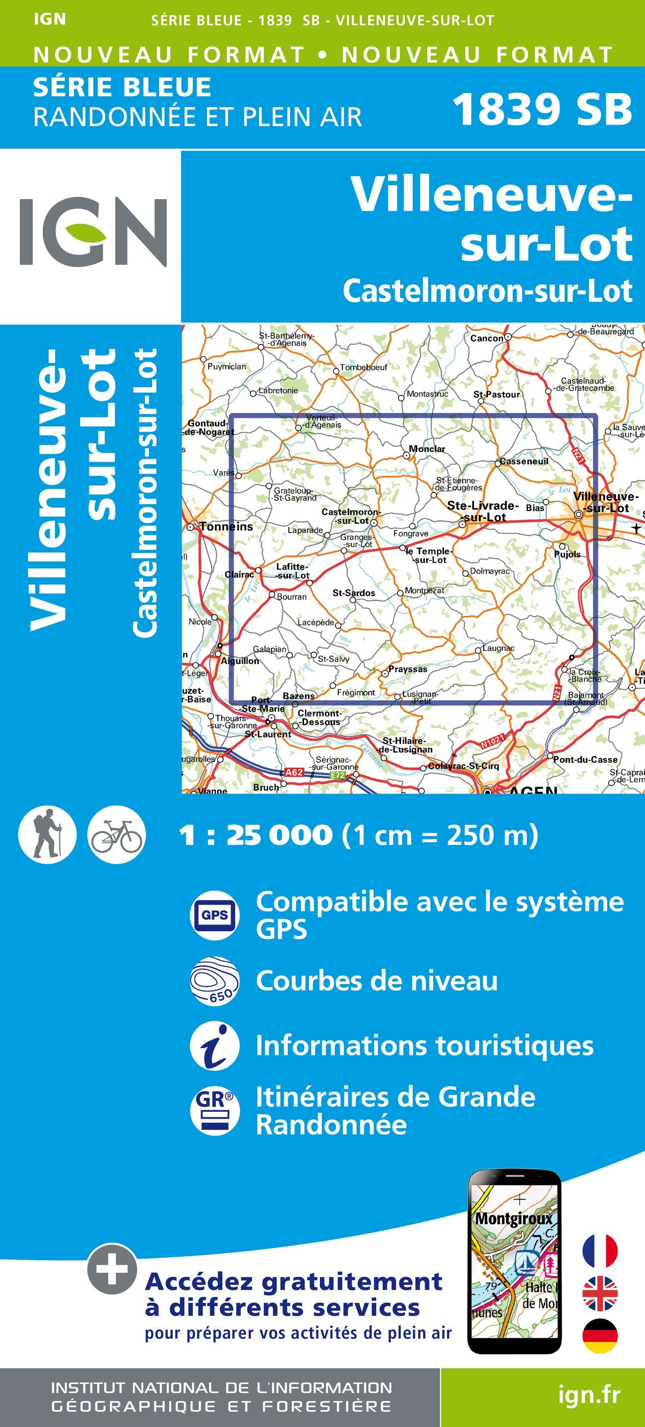
Wandelkaart 1839 SB Villeneuve-sur-Lot & Castelmoron-sur-lot
Villeneuve-sur-Lot & Castelmoron gelegen in de Lot-et-Garonne
Korte omschrijving
Wandelkaarten Nouvelle-Aquitaine, Frankrijk van Institut Géographique National. Ideaal voor tochten in Frankrijk.
Wandelkaart - Villeneuve-sur-Lot & Castelmoron-sur-lot Productomschrijving: Deze topografische kaarten hebben een zeer nauwkeurige gronddetail, niet te vergeten de topografische hoogteprofi...

Specificaties
- Uitgever: Institut Géographique National
- ISBN-13: 9782758533153
- HOOFDCATEGORIEËN: Wandelkaart
- Activiteiten: Wandelen, Hiking & Trekking
- Regio: Nouvelle-Aquitaine, Frankrijk
- Land: Frankrijk
- Departement: Lot-et-Garonne (47)
- Schaal: 1:25000
- Editie: 1
- Taal: Frans
- Reeks/Serie: IGN France > TOP25 Randoo / Série Bleue
Volledige omschrijving
Wandelkaart - Villeneuve-sur-Lot & Castelmoron-sur-lot
Productomschrijving: Deze topografische kaarten hebben een zeer nauwkeurige gronddetail, niet te vergeten de topografische hoogteprofielen, die het wandelen een stuk gemakkelijker maken. Villeneuve-sur-Lot is een gemeente in het Franse departement Lot-et-Garonne (regio Aquitanië). De plaats maakt deel uit van het arrondissement Villeneuve-sur-Lot.
Desciptive produits: Ces cartes topographiques d'une très grande précision contiennent tous les détails existant sur le terrain: voies de communication jusqu'au moindre sentier, constructions jusqu'au hangar, bois, arbre isolé, rivière, source... Sans oublier la représentation du relief par des courbes de niveau.
Locatie op kaart
Artikelen uit dezelfde regio

Wandelkaart Néouvielle- Gavarnie- Midi de Bigorre - Ed. Alpina • 9788470110931
Néouvielle- Gavarnie- Midi de Bigorre - Alpina Productomschrijving: Het Parc National des Pyrénées strekt zich uit over meer dan 100 kilometer, over 6 valleien, 2 departementen (Pyrénées-Atlantiques en Hautes-Pyrénées) en twee regio's (Nouvelle Aquitaine en Occitanie). Deze twee kaarten hebben betrekking op het oostelijke deel van het park, met inbegrip van het Réserve Naturelle Nationale …

Wandelkaart 641 Tour de la Vallée d'Ossau - FFR • 9782751413674
Wandelkaart Tour de la Vallée d'Ossau - FFR Productomschrijving: La vallée d'Ossau est l'une des trois vallées des Pyrénées béarnaises ouvrant le passage vers l'Espagne. Ce parcours effectue une boucle sur la moitié nord de la vallée, façonnée par les glaciers, où se côtoient prairies, forêts, sommets escarpés, en parfaite harmonie avec l'activité humaine omniprésente. Il s'agit d'un itin…

Fietsgids Chateaux de la Loire à vélo - Le Routard • 9782017228394
Chateaux de la Loire à vélo - Le Routard Productomschrijving: Le Routard vous invite à enfourcher votre vélo pour découvrir la région des châteaux de la Loire autrement ! Suite au succès de son album La France à vélo, Le Routard s’attaque à présent aux routes de nos régions, dans un nouveau format facile à transporter. Nous avons sélectionné pour vous plus de 20 itinéraires pour sillon…

Wandelkaart 1442 SB Tartas & Pontonx-sur-l'Adour - IGN • 9782758541172
Wandelkaart 1442 SB, NOUVELLE Série Bleue, Tartas & Pontonx-sur-l'Adour (9782758541172) IGN Productomschrijving: Tartas is een gemeente in het Franse departement Landes in de regio Nouvelle-Aquitaine. De plaats maakt deel uit van het arrondissement Dax. Desciptive produits: Une nouvelle cartographie pour une lisibilité optimale, avec une meilleure précision géométrique et des informati…

Wandelkaart 1628 SB Saint-Maixent-l'Ecole & Lezay - IGN • 9782758553847
Wandelkaart Saint-Maixent-l'Ecole & Lezay - IGN Productomschrijving: Saint-Maixent-l'Ecole & Lezay zijn gemeentes in het Franse departement Deux-Sèvres, in de regio Nouvelle-Aquitaine. De plaats maakt deel uit van het arrondissement Niort. Omvat: Aigondigné, Prailles-La Couarde, Soudan, Sepvret, Exoudun, Lezay, Prahecq, Romans, Vouillé, Beaussais-Vitré, Cherveux, Azay-le-Brûlé, La Crè…