
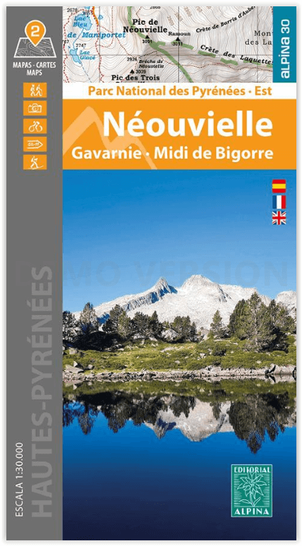
Wandelkaart Néouvielle- Gavarnie- Midi de Bigorre - Ed. Alpina
Parce National de Pyrénées Est
Korte omschrijving
Wandelkaarten Occitanië, Frankrijk en Nouvelle-Aquitaine, Frankrijk van Editorial Alpina S.L.. Ideaal voor tochten in Frankrijk.
Néouvielle- Gavarnie- Midi de Bigorre - Alpina Productomschrijving: Het Parc National des Pyrénées strekt zich uit over meer dan 100 kilometer, over 6 valleien, 2 departementen (Pyrénées-Atl...

Specificaties
- Uitgever: Editorial Alpina S.L.
- ISBN-13: 9788470110931
- HOOFDCATEGORIEËN: Wandelkaart
- Activiteiten: Wandelen, Hiking & Trekking
- Regio: Nouvelle-Aquitaine, Frankrijk, Occitanië, Frankrijk
- Land: Frankrijk
- Departement: Hautes-Pyrénées (65), Pyrénées-Atlantiques (64)
- Nationale parken: Pyrénées NP, Frankrijk
- Regionale parken: Réserve Naturelle Nationale du Néouvielle, Frankrijk
- TOPO's & Stafkaarten: Topografisch wandelen
- Schaal: 1:30000
- Taal: Engels
- Reeks/Serie: Alpina 30
Volledige omschrijving
Néouvielle- Gavarnie- Midi de Bigorre - Alpina
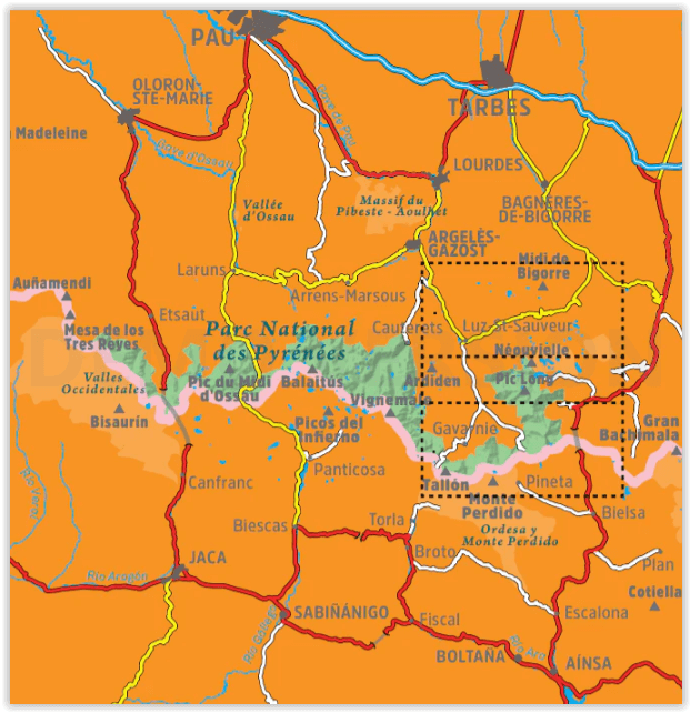
Productomschrijving: Het Parc National des Pyrénées strekt zich uit over meer dan 100 kilometer, over 6 valleien, 2 departementen (Pyrénées-Atlantiques en Hautes-Pyrénées) en twee regio's (Nouvelle Aquitaine en Occitanie). Deze twee kaarten hebben betrekking op het oostelijke deel van het park, met inbegrip van het Réserve Naturelle Nationale du Néouvielle, de keteldalen van Gavarnie, Estaubé, Troumouse en Barroude, evenals de Pic du Midi de Bigorre, buiten het beschermde gebied.
Engelse omschrijving: The Parc National des Pyrénées stretches over one hundred kilometers, across six valleys, two departments (Pyrénées-Atlantiques and Hautes-Pyrénées), and two regions (Nouvelle Aquitaine and Occitanie), along the border with Spain. These two maps cover the eastern sector of the park, including the Réserve Naturelle Nationale du Néouvielle, the cirques of Gavarnie, Estaubé, Troumouse, and Barroude, as well as the Pic du Midi de Bigorre, outside the protected area
2 hiking maps in one folder
•Scale 1:25.000
•Equidistance contours: 10 m distance
•Master contours: at 50 m
•Shady relief
•Compatible with GPS
•Land use symbolized at three levels
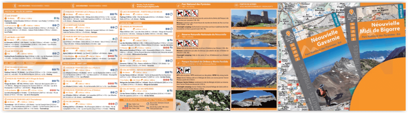
20 Hikes:
• Geographic information
• The top 10 touristic highlights
Covered area: Parc National des Pyrénées. Hautes-Pyrénées. Néouvielle, Gavarnie, and Midi de Bigorre sector.Map features: Two topographic maps, scale 1:30.000, with hiking and tourist information: Mountain huts, signposted footpaths (GR’s, PR’s, local), routes to the summits, access to the starting points of the hikes, etc
The folding flap includes:
• 20 Hikes
• Geographic information
• The top 10 touristic highlights
Artikelen uit dezelfde regio

Wandelkaart 1625 SB Thouars & Airvault - IGN • 9782758537069
Wandelkaart 1625 SB - Thouars & Airvault Productomschrijving: Thouars & Airvault zijn gemeentes in het Franse departement Deux-Sèvres, regio Poitou-Charentes. De plaats maakt deel uit van het arrondissement Bressuire. Tussen 2014 en 2018, worden alle SERIE BLUE kaarten in de collectie vernieuwd. Een nieuwe kaart voor optimale leesbaarheid, met de precieze meetkundige en rijke toeristische …

Wandelkaart 2841 OT Vézénobres & Moussac - IGN • 9782758558873
Wandelkaart Vézénobres & Moussac - IGN Productomschrijving: Deze is te vinden in het departement van de Gard in de regio Occitanië, en omvat Vézénobres & Moussac. Vézénobres is een middeleeuws dorp in het departement Gard (regio Occitanie), prachtig gelegen op een rotsachtige heuveltop aan de voet van de Cevennen. Het dorp staat officieel te boek als een Village de Caractère. Omvat…

Wandelkaart Fietskaart TOP100 D86 Le Vienne - IGN • 9782758556701
Wandelkaart Fietskaart Le Vienne - IGN Productomschrijving: Cette nouvelle édition possède un nouveau découpage départemental. Elle intègre les parcours vélo en partenariat avec l'association AF3V – VéloRoutes et Voies Vertes. La nouvelle TOP 100 grâce à son échelle au 1:100 000ème (1 cm = 1 km) est la carte idéale pour découvrir une région et faire du tourisme à pied, à vélo ou en voitur…

Wandelkaart 1525 SB Bressuire & Cerizay - IGN • 9782758537007
Wandelkaart 1525 SB - Bressuire & Cerizay - Nieuwe versie Productomschrijving: Bressuire is een gemeente in het Franse departement Deux-Sèvres, regio Poitou-Charentes) Tussen 2014 en 2018, worden alle SERIE BLUE kaarten in de collectie vernieuwd. Een nieuwe kaart voor optimale leesbaarheid, met de precieze meetkundige en rijke toeristische informatie. Het formaat van de nieuwe SERIE BL…
Wandelkaart 2941 OT Uzès- Remoulins & Pont du Gard - IGN • 9782758557494
Wandelkaart Uzès- Remoulins & Pont du Gard - IGN Productomschrijving: Deze is gelegen in de regio van Occitanië nambij Avignon, in het departement van de Gard. Omvat: Uzès, Remoulins, Castillon-du-Gard, Saint-Hilaire-d'Ozilhan, Sainte-Anastasie, La Bruguière, Poulx, Sanilhac-Sagriès, Serviers-et-Labaume, Saint-Hippolyte-de-Montaigu, Connaux, Aubussargues, Saint-Bonnet-du-Gard, Saint-Q…