

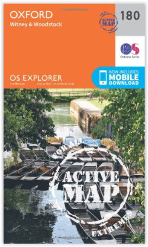
Wandelkaart 180 Oxford- Witney & Woodstock - OSI
Omvat ook de Zuid-west hoek van de Cotswolds AONB


Korte omschrijving
Wandelkaarten Oxfordshire west England van Ordnance Survey. Ideaal voor tochten in England.
Wandelkaart Oxford- Witney & Woodstock - W. England Productbeschrijving: Kaart nummer 180 in de OS Explorer reeks heeft betrekking op Oxford, Woodstock, Witney, Thame, Kidlington en Ot Moor...

Specificaties
- Uitgever: Ordnance Survey
- ISBN-13: 9780319470527
- HOOFDCATEGORIEËN: Wandelkaart
- Activiteiten: Wandelen, Hiking & Trekking
- Regio: Oxfordshire west England
- Land: England
- Waterafstotende kaart: Ordnance Survey ACTIVE Explorer Weatherproof Maps
- TOPO's & Stafkaarten: Topografisch wandelen
- Schaal: 1:25000
- Taal: Engels
- Reeks/Serie: Explorer ACTIVE Series OSI
Volledige omschrijving
Wandelkaart Oxford- Witney & Woodstock - W. England
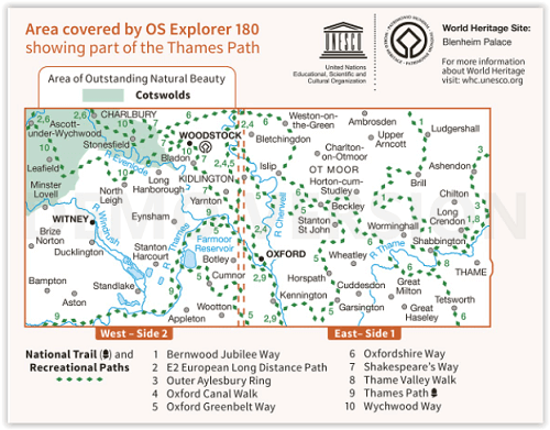
Productbeschrijving: Kaart nummer 180 in de OS Explorer reeks heeft betrekking op Oxford, Woodstock, Witney, Thame, Kidlington en Ot Moor. Hoogtepunten zijn de rivieren Thame, Evenlode, Cherwell en Windrush, en de Zuid-west hoek van de Cotswolds AONB, deel van de "Thames pad" en het "Oxford Canal Walk". De OS Explorer kaart van Oxford is beschikbaar in zowel de standaard papieren versie als de weerbestendige 'Actief' versie.
Productdiscription: Map sheet number 180 in the OS Explorer series covers Oxford, Woodstock, Witney, Thame, Kidlington and Ot Moor. Highlights of the area include: rivers Thame, Evenlode, Cherwell and Windrush, the south west corner of the Cotswolds AONB, part of the Thames Path and the Oxford Canal Walk. The OS Explorer map for Oxford is available in both the standard paper version and weatherproof 'Active' version.
Locatie op kaart
Gekoppelde artikelen

Wandelkaart 180 Oxford- England - OSI • 9780319243732
standaard versieWandelkaart Oxford - England Omvat ook: Witney & Woodstock Productomschrijving: Kaart nummer 180 in de OS Explorer kaarten reeks heeft betrekking op Oxford, Woodstock, Witney, Thame, Kidlington en Ot Moor. Hoogtepunten zijn: de rivieren de Thame, Cherwell Windrush, de Zuid-west hoek van de Cotswolds AONB, een deel van het pad van de Thames, & het Oxford Canal Walk. De OS Explorer kaart…
Wandelkaart 180 Oxford- Witney & Woodstock - OSI • 9780319470527
weatherproof versieWandelkaart Oxford- Witney & Woodstock - W. England Productbeschrijving: Kaart nummer 180 in de OS Explorer reeks heeft betrekking op Oxford, Woodstock, Witney, Thame, Kidlington en Ot Moor. Hoogtepunten zijn de rivieren Thame, Evenlode, Cherwell en Windrush, en de Zuid-west hoek van de Cotswolds AONB, deel van de "Thames pad" en het "Oxford Canal Walk". De OS Explorer kaart van Oxford is…
Artikelen uit dezelfde regio

Fietskaart 02 Cotswold AONB cycling map - Goldeneye • 9781859653036
Fietskaart Cotswold cycling map - Goldeneye Productomschrijving: De Cotswolds zijn een AONB regio, een regio van uitmuntend natuurschoon. In Engeland geklasseerd als AONB, Area of Outstanding Natural Beauty. Zo heeft de UK er een pak verdeeld over het land. De Cotswold kun je een beetje vergelijken met Cornwall, maar dan zonder de kustlijnen. Hier vindt je prachtige landschappen en trails …

Wandelkaart 164 Oxford & Chipping Norton- England - OSI • 9780319262627
Wandelkaart Oxford- Chipping Norton & Bicester - England Productbeschrijving: Oxford is voorzien van een culturele hoogstanding als gevolg van het wereld beroemde hogeschool, met rijke geschiedenis en familiale uitdagingen. OS Landranger kaart 164 heeft betrekking op de 'stad van de droomtorens en het omliggende gebied. Neem een wandeling langs de rivier de Cherwell, en de botanische tuine…

Wandelkaart 191 Banbury Bicester & Chipping Norton- OSI • 9780319470633
Wandelkaart Banbury- Bicester & Chipping Norton England Omvat ook: Brackley. Productbeschrijving: Kaart nummer 191 in de OS Explorer kaarten reeks heeft betrekking op een gedeelte van de Cotswolds en de Macmillan Way en Wychwood way recreatieve paden. Hoogtepunten van het gebied zijn de steden van Banbury, Chipping Norton, Brackley en Bicester, en de Oxford Canal Walk. De OS Explorer k…

Wandelgids Cotswolds - Heart of the Cotswolds - Rucksack Readers • 9781913817268
Wandelgids Cotswolds - Heart of the Cotswolds - Rucksack Productomschrijving: The Cotswolds AONB is quintessentially English, with its rich cultural history, medieval ‘wool’ churches and charming domestic architecture of stone, slate and thatch. The book offers three options for walking in the heart of this wonderful area: a 94-mile (151-km) grand tour starting from Cheltenham, and two sh…

Fietsgids South East Mountain Biking - Vertebrate Publ. • 9781906148058
South East Mountain Biking - Vertebrate Productomschrijving: South East Mountain Biking Ridgeway & Chilterns (Hills AONB) is a compact guide to some of the best mountain bike riding in Southern England, west of London. This guide contains 24 routes from 18 to 38 kilometres long. Each is described with easy-to-follow directions and details of distance, grade of difficulty, refreshment stops…