

Wandelgids Wales backpacker's Britain vol.2 - Cicerone
De Black Mountains- de Brecon Beacons & Forest Fawr


Korte omschrijving
Wandelgidsen Wales van CICERONE Press. Ideaal voor tochten in Wales.
Wandelgids - Wales backpacker's Britain vol.2 - Cicerone Productomschrijving: Gids bevat 25, 2 of 3-daagse wandelingen en nemen wandelaars mee in de meest schilderachtige en wilde delen van ...

Specificaties
- Uitgever: CICERONE Press
- ISBN-13: 9781852844080
- HOOFDCATEGORIEËN: Wandelgids
- Activiteiten: Wandelen, Hiking & Trekking
- Regio: Wales
- Land: Wales
- Editie: 1
- Taal: Engels
Volledige omschrijving
Wandelgids - Wales backpacker's Britain vol.2 - Cicerone
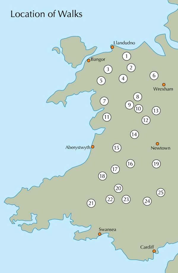
Productomschrijving: Gids bevat 25, 2 of 3-daagse wandelingen en nemen wandelaars mee in de meest schilderachtige en wilde delen van Wales, van Snowdon, de Glyderau en Carneddau in het noorden, naar de Black Mountains en de Brecon Beacons Fforest Fawr in het zuiden, met inbegrip van de ruggen van de Arans, Arenigs, Berwyns en Cadair Idris, de Cwmdeuddwr heuvels en Plynlimon.
Detail: De bergen van Wales zijn een geweldige plek om "get away from it all" voor een paar dagen te ondernemen, en dit boek beschrijft de allerbeste backpacking routes in het Prinsdom. Een totaal van 25 twee - of driedaagse wandelingen nemen u mee in de meest schilderachtige, mooie en wilde delen van Wales, elke één met een nacht of meer, tussen de bergen op wilde campings, bothies of in jeugdherbergen.
Product description: The mountains of Wales are a great place to ‘get away from it all’ for a few days, and this book describes the very best backpacking routes throughout the principality. A total of 25 two- or three-day walks take your into the most scenic, beautiful and wild parts of Wales, each one with a night or more out among the mountains at wild camp sites, bothies or hostels.
- The routes cover all the main mountain ranges, from Snowdon, the Glyderau and Carneddau in the north, down to the Black Mountains.
- Everything in between is included too, such as the superb ridges of the Arans, Arenigs, Berwyns and Cadair Idris, and the bleak moorland.
- Details of equipment, mountain safety and navigation as well as a bibliography make this a complete guide of backpacking in Wales.
- This is the second volume
Locatie op kaart
Artikelen uit dezelfde regio

Wandelgids Classic Day Walks in England & Wales - Vertebrate Publ • 9781839810695
Classic Day Walks in England & Wales - Vertebrate Productomschrijving: 20 of the UK’s best walks Classic Day Walks in England & Wales features a selection of 20 of the best day-length hillwalking routes from Vertebrate Publishing’s popular series of walking guidebooks. Edited by Jon Barton, this guidebook takes you to the best hiking country in England and Wales: take in Lake District…
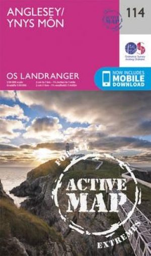
Wandelkaart 114 Anglesey- North West Wales - OSI • 9780319474372
Wandelkaart Anglesey - North West Wales - OSI Productbeschrijving: Kaart nummer 114 in de reeks van de OS Landranger kaarten bestrijkt het platteland Welsh eiland Anglesey. Het is omringd door zandstranden en rotsachtige grotten, met het binnenland dat deel is van het eiland wordt meestal landbouw geteelt. Anglesey is briljant geschikt voor toeristen met een ruime keuze aan accommodatie en…

Wales Hillwalking vol.2 Ffestiniog - Tarrens - Cicerone • 9781852844684
Wales Hillwalking vol.2 Ffestiniog - Tarrens - Cicerone Productomschrijving: De tweede van twee gidsen die wandelen beschrijft in Wales - bespreekt de Ffestiniog heuvels naar de Tarrens. De routes zijn alfabetisch gerangschikt over de twee volumes. Het tweede boek in een tweedelige serie die alle 166 van de wandeltrajecten beschrijft in Wales. Detail: Het resultaat is niet alleen een g…

Wandelgids Wales coast path - Cicerone Press • 9781786312464
Wandelgids Wales coast path - Cicerone Productomschrijving: A single guidebook to walking the whole Wales Coast Path - 1400km (870 miles) the length of Wales from Chester to Chepstow, including Anglesey Island, described in 57 stages. The route passes through the Eryri (Snowdonia) and Pembrokeshire National Parks and many National Landscapes and can be linked with the Offa's Dyke Path for …
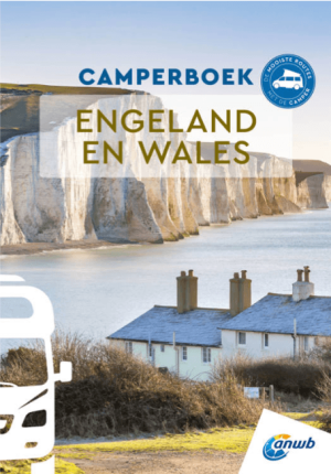
Anwb Camperboek Engeland & Wales - Anwb • 9789018055066
Camperboek Engeland & Wales - Anwb Productomschrijving: Ontdek met het ANWB Camperboek Engeland & Wales de mooiste camperroutes door adembenemende natuur en karaktervolle steden. Rijd langs ruige kusten, groene heuvels, nationale parken en sfeervolle dorpen, met 17 zorgvuldig samengestelde routes vol highlights. Inclusief praktische tips, campings, GPS-coördinaten en inspirerende fotografi…