

Wandelgids Tour des combins two-way trekking guide - Knife Edge
Een geweldig alternatief voor de bekendere Tour du Mont Blanc

Korte omschrijving
Wandelgidsen Aoste, Italië en Wallis, Zwitserland van Knife Edge Outdoor Limited. Ideaal voor tochten in Zwitserland en Italië.
Tour des combins two-way trekking guide - Knife Edge Productomschrijving: De definitieve gids voor de Tour des Combins: de nieuwe bucketlist-trekking roiute in de Zwitserse/Italiaanse Alpen....

Specificaties
- Uitgever: Knife Edge Outdoor Limited
- ISBN-13: 9781912933181
- HOOFDCATEGORIEËN: Wandelgids
- Activiteiten: Wandelen, Hiking & Trekking
- Regio: Aoste, Italië, Wallis, Zwitserland
- Land: Italië, Zwitserland
- Lange afstand wandelroutes: Tour des combins, Wallis Zwitserland (100 Km)
- Editie: 1
- Taal: Engels
Volledige omschrijving
Tour des combins two-way trekking guide - Knife Edge
Productomschrijving: De definitieve gids voor de Tour des Combins: de nieuwe bucketlist-trekking roiute in de Zwitserse/Italiaanse Alpen. Een geweldig alternatief voor de bekendere Tour du Mont Blanc ( TMB) Opgelet, dit is geen gemakkelijke trek, de route is slechts 100 km maar de stijgingen en dalingen, maken de route lang en zwaar. Zorg ervoor dat uw fyziek in orde is.
Engelse omschrijving: The definitive guidebook for the Tour des Combins: the new bucket list trek in the Swiss/Italian Alps. A superb alternative to the more famous Tour du Mont Blanc.
Two-way guide: both clockwise and anti-clockwise routes are described in full.
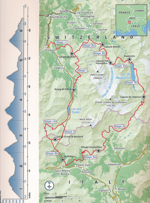
Real Maps: full mapping inside (1:40,000), made specifically for Knife Edge Outdoor Guidebooks. All accommodation/campsites are numbered and marked on the maps.
10 different itineraries: schedules of 6, 7, 8 and 9 days for hikers and runners. Includes both clockwise and anti-clockwise itineraries. Difficult calculations of time, distance and altitude gain/loss are done for you.
Also includes:
• Detailed information on equipment and travelling light
• Full accommodation/campsite listings
• Wild camping rules explained
• Everything the trekker needs to know: route, costs, difficulty, weather and more
• Travel to the trail-head
• Essential info for both self-guided and guided trekkers
• Information on plants and wildlife
• Numbered waypoints linking the Real Maps to our clear descriptions
The Tour des Combins is an epic trek in the Swiss and Italian Alps. It traverses some of Europe's wildest mountain terrain. The sublime scenery makes it a worthy alternative to the more famous Tour du Mont Blanc (which is only a stone's throw away). Hike along the edge of the Corbassière Glacier, one of the longest in Europe. Enjoy snow frosted summits, magnificent valleys and pastures, sparkling azure lakes, carpets of wild flowers, the soothing sound of cow bells and easy to follow paths. Stay in spectacularly situated villages and remote mountain huts. This will be a trip that you will never forget.
Locatie op kaart
Gekoppelde artikelen

Wandelkaart 180M Tour des combins - Knife Edge • 9781912933525
standaard versieWandelkaart Tour des combins - Knife Edge Productomschrijving: De Tour de Combins is 100 km lang, ligt hoofdzakelijk in de regio Wallis in de zwitserse Alpen, met een stukje in de Aoste vallei in Italië. De route is zeer intensief, zorg voor een goed fyzieke conditie. de route is kort maar de stijgingen en dalingingen zijn intens. Engelse omschrijving: The best sheet map for the …
Artikelen uit dezelfde regio

Wandelkaart 3317 T Les Diablerets Wallis - Swisstopo • 9783302333175
Wandelkaart Les Diablerets Wallis - Swisstopo Productomschrijving: Les Diablerets is een gebergte op de grens van de Zwitserse kantons Vaud en Wallis Detail: Een nieuwe serie van de Zwitserse topografische dienst: eindelijk goede wandelkaarten met ingetekende wandelroutes op scheur- en watervast papier. Vooralsnog zijn ze uitgebracht van de populaire wandelgebieden en niet landelijk de…
Reisgids Rough Guides Pocket Geneva Genève - Rough Guides • 9781835290477
Reisgids Pocket Geneva - Rough Guides Productomschrijving: This pocket-sized Geneva guidebook, written by Rough Guides experts, is perfect for short trips. Portable and complete with a pull-out map, it's sustainably printed to support environmental responsibility. Covers: Jet d'Eau, Cathédrale St-Pierre, Carouge, Red Cross and Red Crescent Museum, CERN, Les Pâquis, the UN tour, Cathéd…

Wandelgids Via Francigena - Part 2 Saint Bernard Pass > Toscane - Cicerone • 9781786310866
Via Francigena pilgrim route - Part 2 Productomschrijving: Deze gloed nieuwe gids beschrijft Deel 2 van de pelgrimroute tussen Lausanne in Zwitserland tot de stad Lucca in Italië. De 725 km lange trek loopt over de Alpen via de grote Saint Bernard Pass, daalt dan af naar de Po vallei, over de Cisa pass tot in Toscane in 32 etappes Engelse omschrijving: Guidebook to the Via Francigena p…
Wandelkaart 1325 Sembrancher Wallis - Swisstopo • 9783302013251
Wandelkaart Sembrancher - Wallis Zwitserland - Swisstopo Productomschrijving: Kaart 1325 - Net buiten Martingy gelen langs de E27 weg tussen moiyn gebergtes, ligt dit dorp tussen de bossen. Detail: Zeer gedetailleerde topografische kaarten & wandelkaarten van een klein stuke Zwitserland met schaal 1:25.000.en nr 1011 > 1374. De topografische details van deze kaarten zijn onmetelijk goe…

Wandelkaart 381 Monte Rosa - 4Land • 9791280496119
Wandelkaart Monte Rosa - 4-Land Productomschrijving: Van de gletsjers van 4000 meter tot de valleien die worden doorkruist door de Alta Via 1 van de Valle d'Aosta, van de panoramische toppen van 3000 meter tot de gedempte en geruststellende sfeer van de bossen en weiden, de hoge valleien van de Monte Rosa stralen een bijzondere charme uit, die hen onderscheidt van alle andere gebieden van …